Santhu
| Santhu साँथू Santhoo | |
|---|---|
| village | |
 Santhu Location in Rajasthan, India | |
| Coordinates: 25°18′6″N 72°54′43″E / 25.30167°N 72.91194°ECoordinates: 25°18′6″N 72°54′43″E / 25.30167°N 72.91194°E | |
| Country |
|
| State | Rajasthan |
| District | Jalore |
| Population | |
| • Total | 8,343 |
| Languages | |
| • Official | Hindi |
| Time zone | IST (UTC+5:30) |
| PIN | 343025 |
| Telephone code | 91 2973 |
| Vehicle registration | RJ 16 |
| Nearest city | Bagra (Marwar) |
| Lok Sabha constituency | Jalore |
| Vidhan Sabha constituency | Jalore |
Santhu is a village in Jalore in Jalor) district of Marwar region in Rajasthan state of India. Santhu lies 23 km (14 mi) south of Jalore town and 5 km (3 mi) from Bagra on Jalore-Sirohi road and is surrounded by many villages like Noon (Nun), Chura, Sarat, Akoli, Narnavas, Bibalsar, Mok, Dhanpur, Bhagli Sindhalan, Rewat, Kalapura, Dakatara, Bakra Road, Berath, Bakra Gaon, Rewatada, Dudsi, Dhavala, Bhetala, Siana, Deegaon, etc.
Since old times, people used to say Shotu Sargo Ro Baseno, Noon Nargo Ri Khad', which means living in Santhu is like living in heaven and living in nearby village Noon is like living in hell.
Before independence half of the village was under the Jagir of Shingiji, of Jodhpur Royal family and another half was in the Jagiri of Pharapura Thakur's family.
People
Santhu has population of 8343 (2001 census). Santhu is mainly known for jagirdars Rajpurohit, People of all communities like Rajpurohits, Jains, Rajput Shrimali Brahmans, Rawal Brahmans, Pushkarna Brahmans, Agarwals, Maheshwaris, Sonars, Vaishnavas, Goswamis, Suthars, Rabaris, Ghanchis, Kumhars, Chheepas, Sains, Lohars, Kotwals, Pinjaras, Meghwals, Sargaras, Mochies, Bhils, Damamis / Dholis and Harijans live in Santhu village. Over the last years, many families have migrated to others states of India. Many of them now live in cochin,Tamil Nadu, Andhra Pradesh, Karnataka, Gujarat, Chennai, Bangalore, Vijayawada, Mysore and Mumbai. Over last few decades, some new people have also settled in Santhu. And santhu is the largest community of Jageerdar all over Rajsthan and India.
Facts
Latitude 25.1766°, Longitude 72.5443°, Altitude 501 feet (153 m).
Lat (DMS) 25° 17' N, Long (DMS) 72° 54' E, Altitude 152 meters.
Its nearby railway station names are Marwar Bagra and Bakra Road and is on the Samadari-Bhildi section of North Western Railway. The conversion of the meter gauge rail route to broad gauge has been completed & direct trains from Mumbai has started running on this route to Bikaner via Jodhpur.
Santhu is well connected to all nearby towns by all weather roads. Buses ply through Bagra to all major places. Taxis are available at all times for nearby places from Santhu, Bakra Road and Bagra.
Distances
Nearest Air ports:
Nearest Air strips:
By Road:
- Santhu to Jalore 25 km (16 mi),
- Santhu to Bhinmal 60 km (37 mi),
- Santhu to Jodhpur 165 km (103 mi),
- Santhu to Ahmedabad 360 km (224 mi),
- Santhu to Sirohi 60 km (37 mi),
- Santhu to Sirohi Road 85 km (53 mi),
- Santhu to Abu Road 130 km (81 mi),
- Santhu to Mount Abu 150 km (93 mi),
- Santhu to Jaisalmer 320 km (199 mi),
- Santhu to Ranakpur 115 km (71 mi),
- Santhu to Kheteshwar Brahmadham Tirtha kshetra Asotra 125 km
- Santhu to Kunwarda 50 km
- santhu to dudsi 10 km
santhu to ramdevji ka mandir bagra road 1 km
Economy
Agriculture and animal husbandry are main occupations of the people of Santhu. Santhu is a major production centre of cash crops like oilseeds, isabgol, jeera, and arandi in Jalore district. In last decade many entrepreneurs have set up small scale granite units in nearby towns Bagra, Marwar and Jalore.
Amenities
- For primary medicinal first aid there is a government primary hospital on Bagra Road constructed and maintained by Shri Pavnibai Kapurchandji Pratapji Charitable Trust, Chennai with aid provided by government.
- The facility for first aid for cattle and animals is provided in the government veterinarian hospital of the village.
- The good governance is provided by the elected Panchayat Samiti of the village.
- The nearby police station is situated in Bagra, Marwar.
- The post and telegraph office of the village provides all sort of postal facilities.
- The banking facility is provided by MGB Gramin Bank, Santhu.
- There are two Upashrayas (Mediation Halls), one of which is under construction whereas another one is final and functional and also community hall for conducting marriages and ceremonial functions is well maintained by the Jain community. Also Aayambil Bhavan, providing facility for Aayambil Tapa i.e. a Jains Vow in which one eats for one-time in a day only boiled food without spices and butter, ghee, oil or milk foods and drinking boiled water only in day time.
- There is a separate community hall known as Rajpurohits Kotadi maintained by the large Rajpurohit community of the village.
Special
- Shri Apeshwar Mahadev Gaushala set up in 2000 in the outskirts of the village, a shelter for cows. The Gaushala take care of the cows with public donation.
- Beautifully built Shri Apeshwar Mahadev Kabtoor Chowk in sandstone, a place for feeding pigeons and other birds is another place of charity run by the people of the village.
- A well known as Somiyo Ro Kuo was the main source of water supply in the village in olden days which is recently renovated and additional bore well was also dug with the public donations, also has facility for drinking water for the passer-by animals. Nowadays, Panchayat has provided water supply through pipelines with a good quality of drinking water.
- The good communication facility of basic telephone services along with good mobile network is provided by the government company BSNL and almost all other private companies.
Places of interest
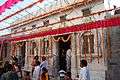
- Shri Munisuvrata-Nemi-Parshva Jinalaya
This one is beautiful jain temple.The Principal deity of this temple are Shri Munisuvrata Swami (twentieth Tirthankara), Neminatha (twenty-second tirthankara) and Parshvanatha (twenty-third Tirthankara).
Gallery
 Shatrunjaya Avtaari Shri Adinath Bhagwan, Santhu.
 Lord Manmohan Parshvanath, Santhu.
 Shri Neminatha Bhagwan, Santhu.
 Shri Munisuvrata Swami Bhagwan, Santhu.
 Shri Jiravala Parshvanath, Santhu.
 Shri Acharya Rajendrasuri Jain Guru Mandir, Santhu.
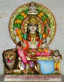
 Shri Baba Ramdev Pir Temple, Santhu.
 Shri Bal Brahmachari Shankar Swarupji Maharaj, Santhu.
See also
| Outline |  | ||||||||||||||||||||||||||
|---|---|---|---|---|---|---|---|---|---|---|---|---|---|---|---|---|---|---|---|---|---|---|---|---|---|---|---|
| Governance | |||||||||||||||||||||||||||
| Divisions and Districts |
| ||||||||||||||||||||||||||
| Major cities | |||||||||||||||||||||||||||
| Related templates |
| ||||||||||||||||||||||||||