Sri Ganganagar district
| Sri Ganganagar district | |
|---|---|
| District of Rajasthan | |
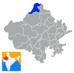 Location of Sri Ganganagar district in Rajasthan | |
| Country | India |
| State | Rajasthan |
| Administrative division | Bikaner Division |
| Headquarters | Sri Ganganagar |
| Area | |
| • Total | 7,984 km2 (3,083 sq mi) |
| Population (2011) | |
| • Total | 1,969,520[1] |
| Website | Official website |
Sri Ganganagar district is a northernmost district of Rajasthan state in western India. It is also the 'breadbasket of Rajasthan'.
History
Named after Maharaja Ganga Singh of Bikaner, Sri Ganganagar district was part of Bikaner state. This was a mostly uninhabited region. The history of this district is testimony to the vision and efforts of Maharaja Ganga Singh, who visualised and built the Gang Canal after the Indian famine of 1899–1900. The waters of the Sutlej River were brought into the region through the 89-mile long Gang Canal in 1927, turning this region into a breadbasket[2] of Rajasthan.
It is said by the elders that this area first came under the erstwhile Bahawalpur princely state but due to the large open area this was unguarded, and Hindu Mal, one of the companions of Maharaja Ganga Singh took advantage of this opportunity and changed the boundaries or the posts along the boundary. He started his journey to change posts from Suratgarh in south till Hindumalkot in north of this district. He informed the Maharaja about his successful invasion of the area when he reached the northern part and thereafter died giving name to the city Hindumalkot.
Geography
Location and area
Sri Ganganagar District is located between Latitude 28.4 to 30.6 and Longitude 72.2 to 75.3[3] The total area of Sri Ganganagar is 11,154.66 km² or 1,115,466 hectares. It is surrounded on the east by Hanumangarh District, (Hanumangarh district was carved out of it on July 12, 1994) on the south by Bikaner District, and on the west by Bahawalnagar district of the Pakistani Punjab and on the north by the Punjab.
Topography
Although Ganganagar District lies in the great Thar desert, irrigation via the Gang canal and Ignp canal has changed the flora and fauna. The district can be classified into five geographical regions:
- The region irrigated by the Gang canal and the Bhakhra canal tributaries: the northern region, which is 3/4 of the district, resembles the fertile plains of Punjab, but some areas, like the area between the towns of Raisinghnagar and Vijaynagar, have desert like conditions.
- Area irrigated by the Suratgarh branch of the IGNP canal
- Area irrigated by Anoopgarh branch of IGNP canal: it comprises Anoopgarh and Gharsana tehsils. It is the southernmost region of the district, of which much has been converted into plains, but sandy dunes can still be seen.
- The Naali belt: this is a narrow basin of the Ghaggar river. It is the only major river of the district. It is a seasonal river, which flows in the rainy season. It enters the district near Suratgarh and then flows in areas of Jaitsar, Vijaynagar, Anoopgarh and then crosses the Indo-Pakistani border.
- The 'Uncha Tibba' (high sandy dunes) area of Suratgarh tehsil: large sandy dunes and lack of water predominate here. This area can be said to be a 'real desert'. People of this area face harsh conditions in the desert.
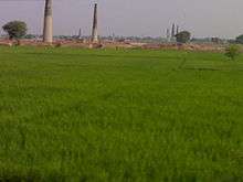
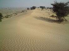 Sandy dunes
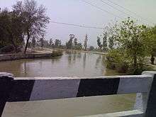 Gang canal irrigates northern-western area of the district; photo taken near Ganganagar city from Ganganagar-Hanumangarh road.
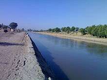 The Anupgarh branch of the IGNP canal is the main source of irrigation in southern tehsils; photo taken in Gharsana Tehsil.
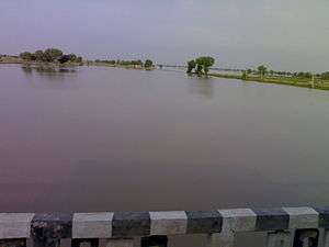 Ghaggar river, near Anoopgarh, in the month of September.
Tehsils and other towns
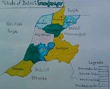
Ganganagar tehsils
There are following nine tehsils in Ganganagar district.
- Sri Ganganagar
- Sri Karanpur, headquarters in the town of Karanpur
- Sadulshahar
- Padampur
- Raisinghnagar
- Suratgarh
- Anoopgarh
- Shri Vijaynagar
- Gharsana
Other major towns and villages
Kesrisinghpur, Gajsinghpur, Raisinghnagar, Jaitsar, Rawla Mandi are major towns, whereas Lalgarh Jatan, Muklawa, Ridmalsar, Rajiasar, Patroda, Sameja Kothi, Chunawadh, Ganeshgarh, Ladhuwala, Hindumalkot, Bajuwala, and Birmana Village Delwan are small towns and villages.
Many towns and cities in Sri Ganganagar District are named after members of the royal family of the former Bikaner State.
Political Representation
Member of Parliament Ganganagar (Lok Sabha constituency) - Nihalchand, Bhartiya Janata Party
Member of Legislative Assembly (Rajasthan) - Kamini Jindal, National Unionist Zamindara Party
Economy
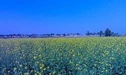
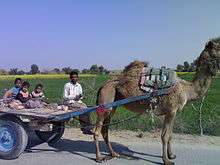
The economy of Sri Ganganagar District is dependent on agriculture. Major crops of the region are wheat, cotton, mustard, guar, grams, and sugarcane. Horticulture is also becoming popular among farmers. Kinnow (a citrus family fruit) is a popular horticultural product; other fruits of the citrus family are also grown.
Industries in Sri Ganganagar District are based on agriculture. Major industries are cotton ginning and pressing factories, mustard oil mills, wheat flour mills, sugar mills, and cotton spinning and textile factories. Most of the factories are located in and around Sriganganagar City.
Demographics
According to the 2011 census Sri Ganganagar district has a population of 1,969,520,[4] roughly equal to the nation of Slovenia[5] or the US state of New Mexico.[6] This gives it a ranking of 235th in India (out of a total of 640).[4] The district has a population density of 179 inhabitants per square kilometre (460/sq mi) .[4] Its population growth rate over the decade 2001-2011 was 10.06%.[4] Ganganagar has a sex ratio of 887 females for every 1000 males,[4] and a literacy rate of 70.25%.[4]
Languages
Punjabi and Bagri, are the most common spoken language. A number of writers of the district have made contributions to Rajasthani literature, through Bagri.[7] Bagri is spoken only in Ganganagar and Hanumangarh districts and in some tehsils of neighbouring Punjab and Haryana.
Hindi, Punjabi are also used in this district. Hindi and English are official languages.The Punjabi language, as an optional subject, is taught in schools and colleges of the district. Punjabi music is very popular in the Ganganagar district. Bagri and Punjabi both share many common words here.
Religion
Most people practice the Hindu and Sikh religions. People worship folk gods such as Ramdevji, Gogaji and Jambhoji. Many have faith in Pirs and Saints and they visit their khanghahs (shrines). Some practise Islam. Some follow Dera-culture, such as Sachcha-Sauda, Radha-Soami and Nirankari deras.
Culture
Punjabi and Bagri cultures dominate the district.
The embroidered Odhni (mostly red in colour) is a symbol of Bagri women. A long shirt and ghaghro (long frock type clothes) and borlo (a head ornament) is the traditional dress of Bagri women.
Punjabi women wear a suit and salwar with chunni (cloth on head). This attire has also become popular with women of other communities. Some women of the Hindu and Muslim Seraiki people still wear ghaggra (long frock).
The Purdah (or veil) is mainly in vogue among Bagri women. Men mainly wear a pant-shirt, kurta-payjama and dhoti (Punjabis call it the chadara-kurta).§
Traditional Sikh and Rajasthani devotional music is popular. Bollywood songs are listened to with same enthusiasm as in other northern Indian regions.
Media
The district has editions of state level newspapers from Jaipur, which are re-published from Ganganagar and Raisinghnagar. The newspaper Seema Sandesh is published from Ganganagar in Hindi.[9]
"Air Suratgarh", a radio station, broadcasts programmes in Hindi, Rajasthani and Punjabi languages. It was commissioned in 1981 and broadcasts on the 918 kHz frequency.[10] Senior Journalist Satish Beri living in Sri Ganaganagar. loksammat, sima kiran, pratap kesri, bol delhi, fighter, swaran Aabha and janmarg news paper also publish in Sri Ganganagar.Fighter is the daily evening newspaper (Hindi) whose chairman is Senior journalist Mr. Prince Garg.
Tourist attractions
- Historical Gurudwara Buddha Johad. A large gurudwara, which is 85 km from Ganganagar in the south-west. This is a place where Bhai Sukha Singh and Mehtab Singh brought the head of Massa Rangarh (guilty of sacrilege of the Amritsar Golden Temple) and hung it on a tree on August 11, 1740.
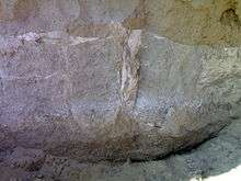
- Baror an archeological site. The ruins of the Indus valley civilisation are found here. The antiquities found here are terracotta cakes,
sling balls, beads and spacer, terracotta, faience and shell bangles etc. It is located on Anoopgarh-Ramsinghpur road.
- Dada Pamparam's Dera is at Vijayanagar town, and is the samadhi (tomb) of Baba Pamparam.
- Laila-Manjnu ki Mazar (tomb), Binjaur village.Laila Majnu Ki Mazar is 11 km (6.6 mi) far from Anoopgarh on the western side. Here is the so-called mazar of Laila-Majnu, actually this was built in remembrance of mutual devotion and love between a teacher and a student. A fair is held in June.
%2CAnupgarh_Sivender.jpg) Laila-Majnun ki Mazar near Anupgarhcity
Laila-Majnun ki Mazar near Anupgarhcity - Chanana-Dham (Chanana shrine). A great temple of Lord Hanumanji is here, built in 1971. It is located 4 km from village 17 BB on the Ganganagar-Padampur road.
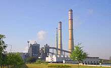
- Suratgarh Thermal power plant.
- Shri Jagadamba Andh-vidhyalaya. One of the largest institutes of India for the education of visually, hearing and speech impaired people. It is situated within Ganganagar city.
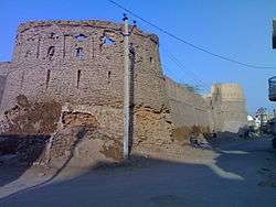
- Anoopgarh Fort is a ruin in the city of Anoopgarh. It was built by Anoop Singh Rathore.
- Suratgarh-Jaitsar state agriculture farm.
Fauna (Animals)
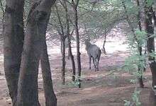
The waters of canals has changed both flora and faunas of this area. Apart from domestic and common animals this area has also some wild animals. Rojh or Neelgai (Boselaphus tragocamelus) are common mammals found in farms and sandy dunes. The farmers have to care about their crops from these animals. Sometimes Neelgai comes on roads and becomes reason of accidents. The snakes.Goh,Sanha(Sanda),Wild rats etc. are other wild animals of this area.
References
- ↑ "Name Census 2011, Rajasthan data" (PDF). censusindia.gov.in. 2012. Retrieved 28 Feb 2012.
- ↑ Garg, Balwant (July 27, 2003). "Suicide woes fill the 'food basket'". The Times Of India.
- ↑ http://ganganagar.nic.in/
- 1 2 3 4 5 6 "District Census 2011". Census2011.co.in. 2011. Retrieved 2011-09-30.
- ↑ US Directorate of Intelligence. "Country Comparison:Population". Retrieved 2011-10-01.
Slovenia 2,000,092 July 2011 est.
- ↑ "2010 Resident Population Data". U. S. Census Bureau. Retrieved 2011-09-30.
New Mexico - 2,059,179
- ↑ M. Paul Lewis, ed. (2009). "Bagri: A language of India". Ethnologue: Languages of the World (16th ed.). Dallas, Texas: SIL International. Retrieved 2011-09-28.
- ↑ http://www.census2011.co.in/census/district/424-ganganagar.html
- ↑ "Seema Sandesh".
- ↑ "Air Suratgarh". All India Radio.
External links
 |
Fazilka district, Punjab | | ||
| Bahawalnagar District, Punjab,Pakistan | |
Hanumangarh district | ||
| ||||
| | ||||
| Bikaner district |
| Outline | 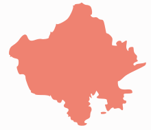 | ||||||||||||||||||||||||||
|---|---|---|---|---|---|---|---|---|---|---|---|---|---|---|---|---|---|---|---|---|---|---|---|---|---|---|---|
| Governance | |||||||||||||||||||||||||||
| Divisions and Districts |
| ||||||||||||||||||||||||||
| Major cities | |||||||||||||||||||||||||||
| Related templates |
| ||||||||||||||||||||||||||
Coordinates: 29°55′04″N 73°52′54″E / 29.91778°N 73.88167°E