Hanumangarh district
| Hanumangarh district | |
|---|---|
| District of Rajasthan | |
 Location of Hanumangarh district in Rajasthan | |
| Country | India |
| State | Rajasthan |
| Administrative division | Bikaner Division |
| Headquarters | Hanumangarh |
| Area | |
| • Total | 12,645 km2 (4,882 sq mi) |
| Population (2011) | |
| • Total | 1,779,650[1] |
| Website | Official website |
Hanumangarh district is a district in the state of Rajasthan in India. The city of Hanumangarh is the district headquarters and its largest city.
District profile
The district is located in the extreme north of Rajasthan. It has an area of 12,645 km², a population of 1,779,650 (2011 census) and a population density of 184 persons/km². It is bounded on the north by Punjab state, on the east by Haryana state, on the south by Churu District of Rajasthan, and on the west by Ganganagar District of Rajasthan. The major work of the district is farming; major crops include rice, millet, cotton, sonamukhi, wheat, and vegetables.
This is the 31st district of Rajasthan. It was made as district on 12 July 1994 from Sri Ganganagar district. Earlier it was one of the Tehsils of Sri Ganganagar district.
The district contains the archaeological site of Kalibangan (Indus Valley Civilisation), and Pallu.
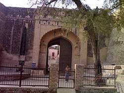
Hanumangarh also has Bhatner Fort which is considered to be one of the oldest forts of India.[2]
Demographics
According to the 2011 census Hanumangarh district has a population of 1,779,650,[4] roughly equal to the nation of The Gambia[5] or the US state of Nebraska.[6] This gives it a ranking of 269th in India (out of a total of 640).[4] Hanumangarh is one of the highest per capita income earning district in India.
The district has a population density of 184 inhabitants per square kilometre (480/sq mi).[4] Its population growth rate over the decade 2001–2011 was 17.24%.[4] Hanumangarh has a sex ratio of 906 females for every 1000 males and a literacy rate of 68.37%.[4]
Languages
Hindi is the official language. Bagri, a dialect of Rajasthani language, or Malvayi, a dialect of Punjabi language, are spoken by majority of population. Haryanyavi, Sindhi, Sansi, and Sikh Bawari are other languages and dialects spoken at small level.
Bagri
Vernaculars include Bagri, a tonal language in the Rajasthani cluster spoken by the majority of people. The district boasts of land of many Rajasthani writers in this dialect. Many villages in southern areas are famous centers for Rajasthani writers .
Punjabi language
Punjabi is second most spoken language of the district. Punjabi has its ground as second language specially in the northern areas like Sangaria, Hanmangarh, Pilibanga tehsils. Punjabi is taught as a third language in many schools and also chosen by students up to postgraduation level. The Malwayi dialect is most common dialect of Punjabi language spoken. Other dialects are Bahawalpuri, Multani spoken by Arora, RaiSikhs communities.[7][8] Culture
Rural kutcha homes with folk art can be seen in some remote villages, but this art is losing ground. Bagri(jaat) culture dominates the district.
Such scenes are common in some southern villages. The embroidered Odhni (mostly red in colour) is a symbol of Bagri women. A long shirt and ghaghro (long frock type clothes) and borlo (a head ornament) is the traditional dress of Bagri women. Punjabi women wear a suit and salwar with chunni (cloth on head). This attire has also become popular with women of other communities. Some women of the Hindu and Muslim Seraiki people still wear ghaggra (long frock).The Purdah (or veil) is mainly in vogue among Bagri women. Men mainly wear a pant-shirt, kurta-payjama and dhoti (Punjabis call it the chadara-kurta). Punjabi music is very popular and are listened to with the same enthusiasm as in other northern Indian regions.
Tehsils
Hanumangarh district has seven tehsils: Hanumangarh, Sangaria, Rawatsar, Nohar, Bhadra, Tibbi and Pilibanga.
Fairs and carnivals
Bhadrakali Mela- The historical Bhadrakali is situated 7 kilometres (4.3 mi) from the district headquarters. The sixth emperor of Bikaner Maharaja Ram Singh is said to have constructed this temple on Emperor Akbar's desire. Though pilgrims visit the temple throughout the year but during the Mela days on Chaitra Sudi 8 and 9, thousands of pilgrims from Punjab, Haryana and Rajasthan visit the temple to worship Bhadrakali.
Pallu Mela- Pallu, around 80 kilometres (50 mi) from the district headquarters is surrounded by sand dunes and is where Mata Brahmani Mela takes place during Navaratras.
Shila Mata Mela- Shila Mata Mela takes place on every Thursday near Bus Stand, Hanumangarh Town. This 6' x 2.5' x 2' size stone is worshiped by Hindus, Sikhs and Muslims. The Hindus-Sikhs call this Shila Mata and Muslims call it Shila Peer.
Shaid Baba Sukha Singh ji, Mahitab Singh ji Yadgari Mela- Shaid Baba Sukha Singh, Mahitab Singh came to Hanumangarh where he rest under a tree where in present a big fantastic Sikh Gurudawara close to Bhatner fort and it is said that tree still exists.A fair on every '25, Bhadhon Mahina' (a Hindi month) is joined by people from all castes and religion including various political leaders.This shows harmony among various groups in society of Hanumangarh and Rajasthan.
Gogameri Mela-Gogameri Mela takes place on every year in Nohar tehsil. This fair is held to worship Gogaji, a deity of Rajasthan.
References
- ↑ "Name Census 2011, Rajasthan data" (PDF). censusindia.gov.in. 2012. Retrieved 28 Feb 2012.
- ↑ "Hanumangarh | India". Encyclopedia Britannica. Retrieved 2016-11-11.
- ↑ http://www.census2011.co.in/census/district/424-ganganagar.html
- 1 2 3 4 5 "District Census 2011". Census2011.co.in. 2011. Retrieved 2011-09-30.
- ↑ US Directorate of Intelligence. "Country Comparison:Population". Retrieved 2011-10-01.
Gambia, The 1,797,860 July 2011 est.
- ↑ "2010 Resident Population Data". U. S. Census Bureau. Retrieved 2011-09-30.
Nebraska 1,826,341
- ↑ M. Paul Lewis, ed. (2009). "Bagri: A language of India". Ethnologue: Languages of the World (16th ed.). Dallas, Texas: SIL International. Retrieved 2011-09-28.
- ↑ Lakhan Gusain 2000. Bagri. (Languages of the World/Materials, 384). Munich: Lincom Europa ISBN 389586398X

| Outline | 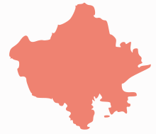 | ||||||||||||||||||||||||||
|---|---|---|---|---|---|---|---|---|---|---|---|---|---|---|---|---|---|---|---|---|---|---|---|---|---|---|---|
| Governance | |||||||||||||||||||||||||||
| Divisions and Districts |
| ||||||||||||||||||||||||||
| Major cities | |||||||||||||||||||||||||||
| Related templates |
| ||||||||||||||||||||||||||
Coordinates: 29°34′48″N 74°19′12″E / 29.58000°N 74.32000°E