Sandray
Not to be confused with Sanday (disambiguation).
| Gaelic name | Sanndraigh |
|---|---|
| Meaning of name | Sand island (Norse) |
| Location | |
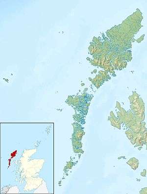 Sandray Sandray shown within the Outer Hebrides | |
| OS grid reference | NL651914 |
| Physical geography | |
| Island group | Barra |
| Area | 385 hectares (1.49 sq mi) |
| Area rank | 77 [1] |
| Highest elevation | Carn Ghaltair 207 metres (679 ft) |
| Administration | |
| Sovereign state | United Kingdom |
| Country | Scotland |
| Council area | Na h-Eileanan Siar |
| Demographics | |
| Population | uninhabited since 1934 |
| References | [2][3][4] |
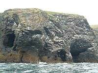
Sandray (Scottish Gaelic: Sanndraigh) is one of the Barra Isles in the Outer Hebrides of Scotland. It never had a large population, and has been uninhabited since 1934. It is now known for its large seabird colony.
Geography
Sandray is half a mile due south of Vatersay, and east of Flodaigh, north east of Lingeigh and Pabaigh. Maol Domhnaigh/Muldoanich is to the north east of it.
Footnotes
- ↑ Area and population ranks: there are c. 300 islands over 20 ha in extent and 93 permanently inhabited islands were listed in the 2011 census.
- ↑ 2001 UK Census per List of islands of Scotland.
- ↑ Ordnance Survey
- ↑ Iain Mac an Tailleir. "Placenames" (PDF). Pàrlamaid na h-Alba. Retrieved 2007-07-23.
|  | ||||||||||||||||||||||||||||
|
| |||||||||||||||||||||||||||||
| |||||||||||||||||||||||||||||
| |||||||||||||||||||||||||||||
| |||||||||||||||||||||||||||||
| |||||||||||||||||||||||||||||
| |||||||||||||||||||||||||||||
| |||||||||||||||||||||||||||||
Coordinates: 56°53′36″N 7°31′0″W / 56.89333°N 7.51667°W
This article is issued from Wikipedia - version of the 2/28/2016. The text is available under the Creative Commons Attribution/Share Alike but additional terms may apply for the media files.