San Remo, Victoria
| San Remo Victoria | |
|---|---|
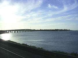 Bridge connecting San Remo with the adjacent town of Newhaven | |
 San Remo | |
| Coordinates | 38°31′0″S 145°22′0″E / 38.51667°S 145.36667°ECoordinates: 38°31′0″S 145°22′0″E / 38.51667°S 145.36667°E |
| Population | 1,017 (2006 census)[1] |
| Postcode(s) | 3925 |
| Location | |
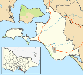
| LGA(s) | Bass Coast Shire |
| State electorate(s) | Bass |
| Federal Division(s) | Flinders |
San Remo is a town in southern Victoria, Australia in the Gippsland region. Formed as a fishing village, its economy is now largely based on tourism. It is also notable as the town on the mainland end of the bridge to Phillip Island. At the 2006 census, San Remo had a population of 1017.
It is located at the western tip of the Anderson Peninsula, 122 km south-east of Melbourne via the South Gippsland Highway, near Kilcunda and opposite Newhaven on Phillip Island.
History
The area around what is now San Remo was occupied for many centuries by the Bunurong people of the Kulin nation. George Bass explored the coast and discovered the strait separating the mainland and Van Diemen's land, together with the bay he named Western Port.
Sealers frequented the coast and Islands in the 1820s before Europeans settled the coast.
Samuel Anderson a Scottish immigrant who in 1835 established the third permanent settlement in Victoria at Bass. Samuel had arrived in Hobart aboard the "Lang" in September 1830 and was employed as bookkeeper for Van Diemens Land Co at Circular Head Tasmania. In 1835 he left the company and sailed to Westernport, it has been suggested that the sloop "Rebecca" was purchased by Samuel and his partner/s.In 1837 his partner Robert Massie also left VDL Co and joined Samuel at Westernport where his skills as an engineer produced a tidal powered mill.Samuels Brothers Hugh and Thomas followed him to Bass and when land was released they bought over 2000 acres centred on the Anderson area today with their homestead "Netherwood" being built on the shores of Westernport.The Anderson brothers and their descendants featured prominently in the local municipal area. An early pioneer and explorer "Anderson Inlet" at Inverloch was named after Samuel Anderson. Descendents of the Anderson family remain around San Remo to this day.[2]
In 1797 George Bass, a naval surgeon and explorer, took a voyage in an open whaleboat to explore the coastline. It was later explored on foot in 1826 by William Hovell. Around 1840 a deepwater port was established at Griffiths Point in order to provide exports of wattle bark, farm produce and cattle, and then later coal starting in the 1870s. A township grew around this port, and brought in tourists. In 1888 the township was named San Remo after the resort town in Italy. The Post Office opened on 14 August 1873 and was renamed San Remo in 1888.[3]
Early in the 20th Century, commercial fishing of the King George whiting came to the area, the produce being sent to Melbourne markets via railway. Since 2006 San Remo has a tidal power test facility. Installed Nereus tidal turbines dispatch power directly to national grid . In 2008 a monument to those local professional fisherman lost at sea was erected. A cairn with the names of those lost at sea with a navigation light atop is a main feature. Today there is a fishing co-operative near the bridge that supplies good fresh fish, particularly the King George whiting for which the area is known.
Festivals and events
The San Remo Channel Challenge is held in February and the San Remo Festival in March.
See also
References
- ↑ Australian Bureau of Statistics (25 October 2007). "San Remo (State Suburb)". 2006 Census QuickStats. Retrieved 2007-10-01.
- ↑ The Andersons of Westernport "Horton & Morris" 1983
- ↑ Premier Postal History, Post Office List, retrieved 2008-04-11