Flinders, Victoria
| Flinders Victoria | |||||||||||||
|---|---|---|---|---|---|---|---|---|---|---|---|---|---|
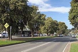 Cook Street, the main street | |||||||||||||
 Flinders | |||||||||||||
| Coordinates | 38°28′26″S 145°01′19″E / 38.474°S 145.022°ECoordinates: 38°28′26″S 145°01′19″E / 38.474°S 145.022°E | ||||||||||||
| Population | 860 (2011 census)[1] | ||||||||||||
| Established | 1854 | ||||||||||||
| Postcode(s) | 3929 | ||||||||||||
| Location | |||||||||||||
| LGA(s) | Shire of Mornington Peninsula | ||||||||||||
| State electorate(s) | Nepean | ||||||||||||
| Federal Division(s) | Flinders | ||||||||||||
| |||||||||||||
Flinders once known as Mendi-Moke, is a town south of Melbourne, Victoria, Australia, located on the Mornington Peninsula at the point where Western Port meets Bass Strait. Its local government area is the Shire of Mornington Peninsula. At the 2011 census, Flinders had a population of 860.[1]
History
The town was named by George Bass after his friend, the explorer and British naval officer Matthew Flinders. Settlement commenced in 1854 and many pioneers and settlers are buried at the Flinders cemetery. Flinders Post Office opened on 7 March 1863 as the population grew.[2]
Present day
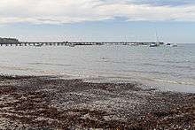
Features of the town include the Flinders Golf Club, a picturesque golf course built on a cliff top,[3] a recreation reserve, a small yacht club, and a 250 metres (820 ft) long pier out from the protected beach, sheltered from the waters of Bass Strait by West Head. This area is popular for sailing, fishing, and other watersports.
On the southern side of West Head, the ocean breaks over the basalt rocks of Mushroom Reef Marine Sanctuary at Flinders ocean beach. Mushroom Reef hosts one of Victoria's best intertidal and subtidal rock platform reefs, popular for beachcombing, recreational diving, snorkelling, and surfing.[4] Several accommodation options exist, including B&Bs and hotel-motel style accommodation. Shopping and a mobile library are also available to tourists and residents.[5][6]
Flinders was the original home of Flinders Bread, available throughout Melbourne and the Mornington Peninsula.[7] The company's operations are now based in Dandenong, but the bread is still available locally.
The Royal Australian Navy operate a weapons training facility and gunnery on West Head, with public access to this area being restricted.
Flinders is served by the 782 bus route from Frankston, operated by Peninsula Bus Lines.[8]
References
- 1 2 Australian Bureau of Statistics (31 October 2012). "Flinders (State Suburb)". 2011 Census QuickStats. Retrieved 2012-10-17.
- ↑ Premier Postal History, Post Office List, retrieved 2008-04-11
- ↑ Golf Select, Flinders, retrieved 2009-05-11
- ↑ "Flinders Ocean Beach - Mushroom Reef". Parks Victoria official site. State Government Victoria. Retrieved 12 April 2013.
- ↑ Mornington Peninsula Business Online. "Find Out More About Flinders".
- ↑ Map 261-262, Melway street directory (28th ed., 2001)
- ↑ "Flinders Bread". Official site. Goodman Fielder. Retrieved 12 April 2013.
- ↑ 782 Frankston-Flinders, effective 19 April 2004. Accessed 27 November 2006.