San Bartolomeo al Mare
| San Bartolomeo al Mare | |
|---|---|
| Comune | |
| Comune di San Bartolomeo al Mare | |
|
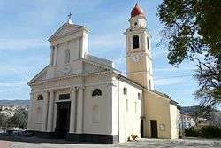
Church of Our Lady | |
 San Bartolomeo al Mare Location of San Bartolomeo al Mare in Italy | |
| Coordinates: 43°55′N 8°6′E / 43.917°N 8.100°ECoordinates: 43°55′N 8°6′E / 43.917°N 8.100°E | |
| Country | Italy |
| Region | Liguria |
| Province / Metropolitan city | Province of Imperia (IM) |
| Area | |
| • Total | 10.9 km2 (4.2 sq mi) |
| Population (Dec. 2004) | |
| • Total | 3,068 |
| • Density | 280/km2 (730/sq mi) |
| Time zone | CET (UTC+1) |
| • Summer (DST) | CEST (UTC+2) |
| Postal code | 18016 |
| Dialing code | 0183 |
San Bartolomeo al Mare is a comune (municipality) in the Province of Imperia in the Italian region Liguria, located about 90 kilometres (56 mi) southwest of Genoa and about 7 kilometres (4 mi) northeast of Imperia. As of 31 December 2004, it had a population of 3,068 and an area of 10.9 square kilometres (4.2 sq mi).[1]
San Bartolomeo al Mare borders the following municipalities: Andora, Cervo, Diano Castello, Diano Marina, Diano San Pietro, and Villa Faraldi.
Demographic evolution

| Wikimedia Commons has media related to San Bartolomeo al Mare. |
References
External links
- Official web site (English)
This article is issued from Wikipedia - version of the 1/31/2015. The text is available under the Creative Commons Attribution/Share Alike but additional terms may apply for the media files.