Airole
| Airole | |
|---|---|
| Comune | |
| Comune di Airole | |
|
Airole | |
 Airole Location of Airole in Italy | |
| Coordinates: 43°52′N 7°33′E / 43.867°N 7.550°ECoordinates: 43°52′N 7°33′E / 43.867°N 7.550°E | |
| Country | Italy |
| Region | Liguria |
| Province / Metropolitan city | Province of Imperia (IM) |
| Frazioni | Collabassa, case Noceire, case Giauma |
| Area | |
| • Total | 14.8 km2 (5.7 sq mi) |
| Elevation | 149 m (489 ft) |
| Population (Dec. 2004) | |
| • Total | 461 |
| • Density | 31/km2 (81/sq mi) |
| Demonym(s) | Airolesi |
| Time zone | CET (UTC+1) |
| • Summer (DST) | CEST (UTC+2) |
| Postal code | 18030 |
| Dialing code | 0184 |
| Website | Official website |

Airole is a comune (municipality) in the Province of Imperia in the Italian region of Liguria, located about 130 kilometres (81 mi) southwest of Genoa and about 40 kilometres (25 mi) west of Imperia, on the border with France. As of 31 December 2004, it had a population of 461 and an area of 14.8 square kilometres (5.7 sq mi).[1]
The municipality of Airole contains the frazioni (subdivisions, mainly villages and hamlets) Collabassa, case Noceire, and case Giauma.
Airole borders the following municipalities: Breil-sur-Roya (France), Dolceacqua, Olivetta San Michele, and Ventimiglia.
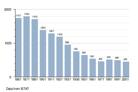
Demographic evolution
References
External links
This article is issued from Wikipedia - version of the 1/31/2015. The text is available under the Creative Commons Attribution/Share Alike but additional terms may apply for the media files.