Ospedaletti
| Ospedaletti Spiareti | |
|---|---|
| Comune | |
| Comune di Ospedaletti | |
|
Ospedaletti | |
 Ospedaletti Location of Ospedaletti in Italy | |
| Coordinates: 43°48′N 7°43′E / 43.800°N 7.717°ECoordinates: 43°48′N 7°43′E / 43.800°N 7.717°E | |
| Country | Italy |
| Region | Liguria |
| Province / Metropolitan city | Province of Imperia (IM) |
| Frazioni | Porrine |
| Area | |
| • Total | 5.2 km2 (2.0 sq mi) |
| Population (Dec. 2004) | |
| • Total | 3,500 |
| • Density | 670/km2 (1,700/sq mi) |
| Demonym(s) | Ospedalettesi |
| Time zone | CET (UTC+1) |
| • Summer (DST) | CEST (UTC+2) |
| Postal code | 18014 |
| Dialing code | 0184 |
| Website | Official website |
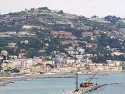
Ospedaletti (Spiareti in the local variety of Ligurian (Romance language)) is a comune (municipality) in the Province of Imperia in the Italian region of Liguria, located about 120 kilometres (75 mi) southwest of Genoa and about 25 kilometres (16 mi) southwest of Imperia. As of 31 December 2004, it had a population of 3,500 and an area of 5.2 square kilometres (2.0 sq mi).[1]
The municipality of Ospedaletti contains the frazione (subdivision) Porrine.
Ospedaletti borders the following municipalities: Bordighera, Sanremo, Seborga, and Vallebona.
History
Ospedaletti is named after a 14th-century hospital which was established by the Knights of Saint John of Jerusalem.
Geography
Located between Caponero and Cape Sant'Ampelio, just six kilometers from Sanremo, it gets some north winds. It is about 30 kilometres (19 mi) from Imperia, the provincial capital. The lush, sub-tropical vegetation, combined with a moderate and refined urbanization, makes Ospedaletti the pearl of the Riviera dei Fiori (Coast of Flowers). The climate is usually mild.
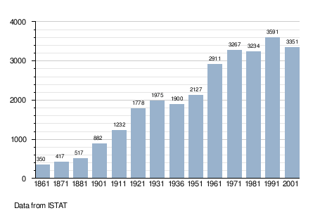
Demographic evolution
Twin towns — Sister cities
Ospedaletti is twinned with:
-
 Soulac-sur-Mer, France (1972)
References
External links
- Official site of Ospedaletti (Italian)