Sams Valley, Oregon
| Sams Valley | |
|---|---|
| Unincorporated community | |
 Sams Valley  Sams Valley Location within the state of Oregon | |
| Coordinates: 42°29′30″N 122°58′27″W / 42.49167°N 122.97417°WCoordinates: 42°29′30″N 122°58′27″W / 42.49167°N 122.97417°W | |
| Country | United States |
| State | Oregon |
| County | Jackson |
| Time zone | Pacific (PST) (UTC-8) |
| • Summer (DST) | PDT (UTC-7) |
| ZIP code | 97525 |
| Area code(s) | 458 and 541 |
Sams Valley is an unincorporated community in Jackson County, Oregon, United States, on Oregon Route 234 northeast of Gold Hill, in the Medford area.
Originally named "Moonville",[1] the community takes its name from a valley that was named after Chief Sam of the Rogue River tribe of Native Americans.[2] Sams Valley post office ran from 1873 until 1953.[2] Today residents consider the communities of Beagle, Antioch and Table Rock part of Sams Valley.[1]
References
- 1 2 Fattig, Paul (September 19, 1999). "Speaking up for Sams Valley". Mail Tribune.
- 1 2 McArthur, Lewis A.; Lewis L. McArthur (2003) [1928]. Oregon Geographic Names (Seventh ed.). Portland, Oregon: Oregon Historical Society Press. p. 844. ISBN 0-87595-277-1.
Municipalities and communities of Jackson County, Oregon, United States | ||
|---|---|---|
| Cities | 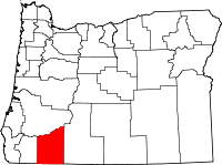 | |
| CDPs | ||
| Other unincorporated communities | ||
| Ghost towns | ||
This article is issued from Wikipedia - version of the 7/30/2016. The text is available under the Creative Commons Attribution/Share Alike but additional terms may apply for the media files.