Brownsboro, Oregon
| Brownsboro | |
|---|---|
| Unincorporated community | |
 Brownsboro  Brownsboro Location within the state of Oregon | |
| Coordinates: 42°28′05″N 122°42′36″W / 42.46806°N 122.71000°WCoordinates: 42°28′05″N 122°42′36″W / 42.46806°N 122.71000°W | |
| Country | United States |
| State | Oregon |
| County | Jackson |
| Elevation[1] | 1,437 ft (438 m) |
| Time zone | Pacific (PST) (UTC-8) |
| • Summer (DST) | PDT (UTC-7) |
| ZIP code | 97524 |
| Area code(s) | 458 and 541 |
| GNIS feature ID | 1118139[1] |
Brownsboro is an unincorporated community in Jackson County, Oregon, United States,[1] located on Oregon Route 140 about 4 miles (6 km) east of Eagle Point.
References
- 1 2 3 "Brownsboro". Geographic Names Information System. United States Geological Survey. November 28, 1980. Retrieved September 13, 2012.
Municipalities and communities of Jackson County, Oregon, United States | ||
|---|---|---|
| Cities | 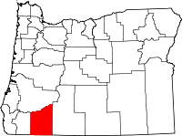 | |
| CDPs | ||
| Other unincorporated communities | ||
| Ghost towns | ||
This article is issued from Wikipedia - version of the 7/30/2016. The text is available under the Creative Commons Attribution/Share Alike but additional terms may apply for the media files.