Saint-Robert, Corrèze
| Saint-Robert | ||
|---|---|---|
|
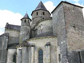
The church in Saint-Robert | ||
| ||
 Saint-Robert | ||
|
Location within Nouvelle-Aquitaine region  Saint-Robert | ||
| Coordinates: 45°15′22″N 1°17′38″E / 45.2561°N 1.2938°ECoordinates: 45°15′22″N 1°17′38″E / 45.2561°N 1.2938°E | ||
| Country | France | |
| Region | Nouvelle-Aquitaine | |
| Department | Corrèze | |
| Arrondissement | Brive-la-Gaillarde | |
| Canton | Ayen | |
| Intercommunality | Bassin d'Objat | |
| Government | ||
| • Mayor (2001–2008) | Jean-Louis Descomps | |
| Area1 | 6.08 km2 (2.35 sq mi) | |
| Population (2008)2 | 343 | |
| • Density | 56/km2 (150/sq mi) | |
| Time zone | CET (UTC+1) | |
| • Summer (DST) | CEST (UTC+2) | |
| INSEE/Postal code | 19239 / 19310 | |
| Elevation |
158–354 m (518–1,161 ft) (avg. 325 m or 1,066 ft) | |
|
1 French Land Register data, which excludes lakes, ponds, glaciers > 1 km² (0.386 sq mi or 247 acres) and river estuaries. 2 Population without double counting: residents of multiple communes (e.g., students and military personnel) only counted once. | ||
.svg.png)
Saint-Robert is a commune in the Corrèze department in central France.
Population
| Historical population | ||
|---|---|---|
| Year | Pop. | ±% |
| 1962 | 319 | — |
| 1968 | 343 | +7.5% |
| 1975 | 353 | +2.9% |
| 1982 | 371 | +5.1% |
| 1990 | 331 | −10.8% |
| 1999 | 334 | +0.9% |
| 2008 | 343 | +2.7% |
See also
References
| Wikimedia Commons has media related to Saint-Robert (Corrèze). |
This article is issued from Wikipedia - version of the 2/26/2015. The text is available under the Creative Commons Attribution/Share Alike but additional terms may apply for the media files.