Saint-Hilaire-Peyroux
| Saint-Hilaire-Peyroux | ||
|---|---|---|
|
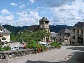
The church and surrounding buildings in Saint-Hilaire-Peyroux | ||
| ||
 Saint-Hilaire-Peyroux | ||
|
Location within Nouvelle-Aquitaine region  Saint-Hilaire-Peyroux | ||
| Coordinates: 45°12′54″N 1°38′58″E / 45.215°N 1.6494°ECoordinates: 45°12′54″N 1°38′58″E / 45.215°N 1.6494°E | ||
| Country | France | |
| Region | Nouvelle-Aquitaine | |
| Department | Corrèze | |
| Arrondissement | Tulle | |
| Canton | Tulle-Campagne-Nord | |
| Government | ||
| • Mayor (2008–2014) | Jean-Claude Peyramard | |
| Area1 | 18.89 km2 (7.29 sq mi) | |
| Population (2008)2 | 899 | |
| • Density | 48/km2 (120/sq mi) | |
| Time zone | CET (UTC+1) | |
| • Summer (DST) | CEST (UTC+2) | |
| INSEE/Postal code | 19211 / 19560 | |
| Elevation | 120–447 m (394–1,467 ft) | |
|
1 French Land Register data, which excludes lakes, ponds, glaciers > 1 km² (0.386 sq mi or 247 acres) and river estuaries. 2 Population without double counting: residents of multiple communes (e.g., students and military personnel) only counted once. | ||
.svg.png)
Saint-Hilaire-Peyroux is a commune in the Corrèze department in central France.
Population
| Historical population | ||
|---|---|---|
| Year | Pop. | ±% |
| 1962 | 1,033 | — |
| 1968 | 1,011 | −2.1% |
| 1975 | 854 | −15.5% |
| 1982 | 787 | −7.8% |
| 1990 | 807 | +2.5% |
| 1999 | 791 | −2.0% |
| 2008 | 899 | +13.7% |
See also
References
| Wikimedia Commons has media related to Saint-Hilaire-Peyroux. |
This article is issued from Wikipedia - version of the 2/11/2016. The text is available under the Creative Commons Attribution/Share Alike but additional terms may apply for the media files.