Saint-Donat, Lanaudière, Quebec
| Saint-Donat | |
|---|---|
| Municipality | |
 | |
_Quebec_location_diagram.png) Location within Matawinie RCM | |
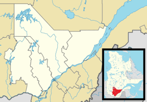 Saint-Donat Location in central Quebec | |
| Coordinates: 46°19′N 74°13′W / 46.317°N 74.217°WCoordinates: 46°19′N 74°13′W / 46.317°N 74.217°W[1] | |
| Country |
|
| Province |
|
| Region | Lanaudière |
| RCM | Matawinie |
| Settled | c. 1876 |
| Constituted | February 19, 1904 |
| Government[2] | |
| • Mayor | Joé Deslauriers |
| • Federal riding | Joliette |
| • Prov. riding | Bertrand |
| Area[2][3] | |
| • Total | 388.40 km2 (149.96 sq mi) |
| • Land | 353.78 km2 (136.60 sq mi) |
| Population (2011)[3] | |
| • Total | 4,130 |
| • Density | 11.7/km2 (30/sq mi) |
| • Pop 2006-2011 |
|
| • Dwellings | 4,414 |
| Time zone | EST (UTC−5) |
| • Summer (DST) | EDT (UTC−4) |
| Postal code(s) | J0T 2C0 |
| Area code(s) | 819 |
| Highways |
|
| Website |
www |
.JPG)
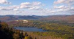
Saint-Donat is a township municipality in the Canadian province of Quebec, part of the Regional County Municipality of Matawinie, within the larger administrative region of Lanaudière.[1] The main town within the township is also identified as Saint-Donat-de-Montcalm to distinguish it from a parish municipality with the same name in La Mitis RCM.[4] It is located approximately 135 kilometres (84 mi) northwest of Montreal. The town is surrounded by mountains and numerous water basins of the Laurentian Mountains. The nearest natural landmark is the Mont-Tremblant National Park.
History
Saint-Donat was founded sometime near 1876 by a religious community of suffragettes as the "Saint-Donat Parish" near the church (located at the intersection of Principale and Allard streets). It was therefore first settled in the mid-to-late 19th century, as a solution to the overcrowding of cities such as Montreal. Over the time, the small village received urban population attracted by its beautiful landscape and the town was officially established in 1904. By 1950, Saint-Donat had reached a population of 2,000. As of 2006, the town was nearing 4,300 permanent residents.
Demographics
Population
| Historical Census Data - Saint-Donat, Lanaudière, Quebec[5] | ||||||||||||||||||||||||||
|---|---|---|---|---|---|---|---|---|---|---|---|---|---|---|---|---|---|---|---|---|---|---|---|---|---|---|
|
|
| ||||||||||||||||||||||||
Private dwellings occupied by usual residents: 2028 (total dwellings: 4414)
Language
All official government actions take place in French, the official language of Quebec. French is the primary language spoken in Saint-Donat, though some people, especially those who deal often with tourists, are able to speak and understand English.
- Mother tongue:
- English as first language: 1.5%
- French as first language: 96.6%
- English and French as first language: 0.6%
- Other as first language: 1.3%
Government
The current mayor of Saint-Donat is Joé Deslauriers. The mayor and a six-member city council are the elected officials of the municipality.
Tourism
Saint-Donat is often frequented by tourists in the winter. Its main attraction is snowmobiling, but other winter sports, such as skiing, can be enjoyed there as well. Its mountains, lakes, and pleasant weather attract many tourists in the summer season. Many people who vacation in Saint-Donat during the summer enjoy swimming or boating on its two large lakes, Lac Archambault and (Lac) Lake Ouareau. Saint-Donat is the only village in the Laurentiens that has two side-by-side lakes of the size of Archambault and Ouareau. Saint-Donat also contains many other smaller lakes such as Lac Baribeau, Lac Pembina, Lac Croche, and others.
The year-round population of Saint-Donat is approximately 3,700, but during the tourist season, the number of people actually in Saint-Donat can reach 20,000. Saint-Donat has been recognized for its beauty and has received national recognition, especially for the quality of its public places. It was first recognized as a prime tourist destination in 1908, by an engineer with the Ministry of Lands and Forests. Hotels, and other businesses necessary in a tourist destination, began within a few decades, and tourism was the focal point of the local economy by 1970.
Twin towns
Saint-Donat is twinned with:
-
 Lans-en-Vercors, France, since 1990
See also
References
- 1 2 "Saint-Donat (Municipalité)" (in French). Commission de toponymie du Québec. Retrieved 2010-03-02.
- 1 2 Ministère des Affaires municipales, des Régions et de l'Occupation du territoire - Répertoire des municipalités: Saint-Donat
- 1 2 Statistics Canada 2011 Census - Saint-Donat census profile
- ↑ "Saint-Donat-de-Montcalm (village)" (in French). Commission de toponymie du Québec. Retrieved 2010-03-03.
- ↑ Statistics Canada: 1996, 2001, 2006, 2011 census
| Wikimedia Commons has media related to Saint-Donat (Matawinie). |
 |
Lac-des-Dix-Milles | Lac-Legendre | Saint-Guillaume-Nord | |
| Lac-Supérieur | |
|||
| ||||
| | ||||
| Val-des-Lacs | Lantier, Sainte-Lucie-des-Laurentides | Notre-Dame-de-la-Merci |
| Municipalities | |
|---|---|
| Parishes | |
| Unorganized Territories | |
| |