Rydal, Georgia
| Rydal, Georgia | |
|---|---|
| Unincorporated community | |
 Rydal, Georgia | |
| Coordinates: 34°20′07″N 84°42′56″W / 34.33528°N 84.71556°WCoordinates: 34°20′07″N 84°42′56″W / 34.33528°N 84.71556°W | |
| Country | United States |
| State | Georgia |
| County | Bartow |
| Area | |
| • Land | 53.6 sq mi (139 km2) |
| Elevation | 0.112 ft (0.034 m) |
| Population (2010 est.)[1] | |
| • Total | 4,087 |
| • Density | 76.2/sq mi (29.4/km2) |
| Time zone | Eastern (EST) (UTC-5) |
| • Summer (DST) | EDT (UTC-4) |
| ZIP code | 30171 |
| Area code(s) | 770 |
| GNIS feature ID | 332948[2] |
Rydal is in Bartow County, Georgia, United States also as known as Pine Log, Georgia. It is thirteen miles north of Cartersville. This still predominantly rural area is unincorporated and includes the historic town of Pine Log. The Pine Log post office is open today and the town and the surrounding area is now frequently referred to as Rydal. In 2000 the population of the greater Rydal area was 2,960. Several historic churches, homes and the Pine Log Elementary School still remain in the community. The community has experienced growth from the continuing outgrowth of Atlanta. Population has risen in the past years and since the 1990s several subdivisions and factories have been built in the area.
Community and Surrounding Areas
Rydal is conveniently located near Adairsville and Cartersville with quick access to Interstate 75. The location of Rydal offers opportunities for residents to quickly reach Atlanta, Rome, and Chattanooga for employment.
References
- ↑ City-data.com
- ↑ "US Board on Geographic Names". United States Geological Survey. 2007-10-25. Retrieved 2008-01-31.
External links
- Pine Log Historical Society
- Marker of Pine Log United Methodist Church
- Founder Stephen Ellis's church and grave
- Old Pine Log Indian Town historical marker
- Historic Pine Log Methodist Church historical marker
Municipalities and communities of Bartow County, Georgia, United States | ||
|---|---|---|
| Cities | 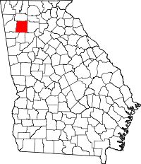 | |
| Town | ||
| Unincorporated communities | ||
| Ghost town | ||
| Footnotes | ‡This populated place also has portions in an adjacent county or counties | |