Ryan, Minnesota
| Ryan, Minnesota | |
|---|---|
| Unincorporated community | |
 Ryan, Minnesota  Ryan, Minnesota Location of the community of Ryan | |
| Coordinates: 44°25′26″N 92°42′56″W / 44.42389°N 92.71556°WCoordinates: 44°25′26″N 92°42′56″W / 44.42389°N 92.71556°W | |
| Country | United States |
| State | Minnesota |
| County | Goodhue County |
| Township | Belle Creek Township |
| Elevation | 1,158 ft (353 m) |
| Time zone | Central (CST) (UTC-6) |
| • Summer (DST) | CDT (UTC-5) |
| ZIP code | 55027 |
| Area code(s) | 651 |
| GNIS feature ID | 654921[1] |
Ryan is an unincorporated community in Belle Creek Township, Goodhue County, Minnesota, United States.
The center of Ryan is generally considered near the intersection of 362nd Street and 165th Avenue.
County 7 Boulevard and Wheat Trail are also in the immediate area. County 7 runs north–south. Nearby County Road 9 runs east–west.
Ryan is located within ZIP code 55027 based in Goodhue.
Nearby places include Goodhue, Cannon Falls, White Rock, Hader, Zumbrota, and Red Wing.
History
Ryan was settled primarily by Irish. It had a stage coach stop on the route between Red Wing and Kenyon.[2] The community also had a post office that operated from 1882 to 1903.[3] In the present day, St. Columbkill's Church remains an attraction in the community.
References
- ↑ "Ryan, Minnesota". Geographic Names Information System. United States Geological Survey.
- ↑ Minnesota Place Names. Minnesota Historical Society. Retrieved on 2009-6-05.
- ↑ U.S. Geological Survey Geographic Names Information System: Ryan Post Office (historical)
Municipalities and communities of Goodhue County, Minnesota, United States | ||
|---|---|---|
| Cities | 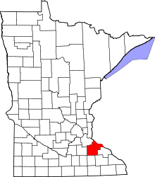 | |
| Townships | ||
| CDP | ||
| Unincorporated communities | ||
| Indian reservation | ||
| Footnotes | ‡This populated place also has portions in an adjacent county or counties | |