Rosedale, West Virginia
For the community in Monongalia County, see Rosedale, Monongalia County, West Virginia.
| Rosedale | |
|---|---|
| Unincorporated community | |
 Rosedale  Rosedale Location within the state of West Virginia | |
| Coordinates: 38°44′21″N 80°56′34″W / 38.73917°N 80.94278°WCoordinates: 38°44′21″N 80°56′34″W / 38.73917°N 80.94278°W | |
| Country | United States |
| State | West Virginia |
| County | Braxton and Gilmer |
| Elevation | 778 ft (237 m) |
| Time zone | Eastern (EST) (UTC-5) |
| • Summer (DST) | EDT (UTC-4) |
| ZIP codes | 26636 |
| GNIS feature ID | 1546077[1] |
Rosedale is an unincorporated community in Braxton and Gilmer counties in the U.S. state of West Virginia. It lies along the Right Fork Steer Creek,[2] at an elevation of 778 feet (237 m).
The community was named after wild rose bushes near the original town site.[3]
References
- ↑ U.S. Geological Survey Geographic Names Information System: Rosedale, West Virginia
- ↑ West Virginia Atlas & Gazetteer. Yarmouth, Me.: DeLorme. 1997. p. 44. ISBN 0-89933-246-3.
- ↑ Kenny, Hamill (1945). West Virginia Place Names: Their Origin and Meaning, Including the Nomenclature of the Streams and Mountains. Piedmont, WV: The Place Name Press. p. 541.
Municipalities and communities of Braxton County, West Virginia, United States | ||
|---|---|---|
| Towns | 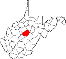 | |
| Unincorporated communities |
| |
| Ghost towns | ||
| Footnotes | ‡This populated place also has portions in an adjacent county or counties | |
Municipalities and communities of Gilmer County, West Virginia, United States | ||
|---|---|---|
| Towns | 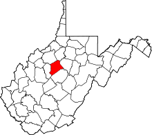 | |
| Unincorporated communities | ||
| Footnotes | ‡This populated place also has portions in an adjacent county or counties | |
This article is issued from Wikipedia - version of the 7/28/2016. The text is available under the Creative Commons Attribution/Share Alike but additional terms may apply for the media files.