Ronan, Montana
| Ronan, Montana | |
|---|---|
| City | |
|
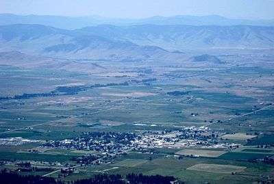
Ronan, Montana as seen from the Mission Mountains in the summer of 2009. | |
 Location of Ronan, Montana | |
| Coordinates: 47°32′N 114°6′W / 47.533°N 114.100°WCoordinates: 47°32′N 114°6′W / 47.533°N 114.100°W | |
| Country | United States |
| State | Montana |
| County | Lake |
| Area[1] | |
| • Total | 1.19 sq mi (3.08 km2) |
| • Land | 1.19 sq mi (3.08 km2) |
| • Water | 0 sq mi (0 km2) |
| Elevation | 3,048 ft (929 m) |
| Population (2010)[2] | |
| • Total | 1,871 |
| • Estimate (2015)[3] | 1,981 |
| • Density | 1,572.3/sq mi (607.1/km2) |
| Time zone | Mountain (MST) (UTC-7) |
| • Summer (DST) | MDT (UTC-6) |
| ZIP code | 59864 |
| Area code(s) | 406 |
| FIPS code | 30-64150 |
| GNIS feature ID | 0775919 |
Ronan (Salish: ocqʔetkʷ[4]) is a city in Lake County, Montana, United States. It lies on the Flathead Indian Reservation about 12 miles south of Flathead Lake in the northwestern part of the state. The population was 1,871 at the 2010 census.
Geography
Ronan is located at 47°32′N 114°6′W / 47.533°N 114.100°W (47.528, −114.100).[5]
According to the United States Census Bureau, the city has a total area of 1.19 square miles (3.08 km2), all of it land.[1]
Climate
This climatic region is typified by large seasonal temperature differences, with warm to hot (and often humid) summers and cold (sometimes severely cold) winters. According to the Köppen Climate Classification system, Ronan has a humid continental climate, abbreviated "Dfb" on climate maps.[6]
Demographics
| Historical population | |||
|---|---|---|---|
| Census | Pop. | %± | |
| 1920 | 600 | — | |
| 1930 | 537 | −10.5% | |
| 1940 | 1,032 | 92.2% | |
| 1950 | 1,251 | 21.2% | |
| 1960 | 1,334 | 6.6% | |
| 1970 | 1,347 | 1.0% | |
| 1980 | 1,530 | 13.6% | |
| 1990 | 1,547 | 1.1% | |
| 2000 | 1,812 | 17.1% | |
| 2010 | 1,871 | 3.3% | |
| Est. 2015 | 1,981 | [7] | 5.9% |
| U.S. Decennial Census[8][9] 2015 Estimate[3] | |||
2010 census
As of the census[2] of 2010, there were 1,871 people, 737 households, and 444 families residing in the city. The population density was 1,572.3 inhabitants per square mile (607.1/km2). There were 807 housing units at an average density of 678.2 per square mile (261.9/km2). The racial makeup of the city was 61.3% White, 0.4% African American, 27.0% Native American, 0.5% Asian, 0.1% Pacific Islander, 0.6% from other races, and 10.1% from two or more races. Hispanic or Latino of any race were 4.7% of the population.
There were 737 households of which 33.8% had children under the age of 18 living with them, 35.8% were married couples living together, 19.5% had a female householder with no husband present, 4.9% had a male householder with no wife present, and 39.8% were non-families. 33.2% of all households were made up of individuals and 13.6% had someone living alone who was 65 years of age or older. The average household size was 2.41 and the average family size was 3.09.
The median age in the city was 34.7 years. 27.7% of residents were under the age of 18; 9.1% were between the ages of 18 and 24; 23.2% were from 25 to 44; 24.1% were from 45 to 64; and 16% were 65 years of age or older. The gender makeup of the city was 46.9% male and 53.1% female.
2000 census
As of the census[10] of 2000, there were 1,812 people, 699 households, and 420 families residing in the city. The population density was 1,701.5 people per square mile (660.0/km²). There were 755 housing units at an average density of 709.0 per square mile (275.0/km²). The racial makeup of the city was 62.42% White, 0.11% African American, 33.06% Native American, 0.11% Asian, 0.06% Pacific Islander, 0.44% from other races, and 3.81% from two or more races. Hispanic or Latino of any race were 3.37% of the population.
There were 699 households out of which 34.3% had children under the age of 18 living with them, 38.6% were married couples living together, 15.6% had a female householder with no husband present, and 39.9% were non-families. 33.8% of all households were made up of individuals and 15.7% had someone living alone who was 65 years of age or older. The average household size was 2.47 and the average family size was 3.18.
In the city the population was spread out with 29.2% under the age of 18, 9.8% from 18 to 24, 23.5% from 25 to 44, 20.8% from 45 to 64, and 16.8% who were 65 years of age or older. The median age was 35 years. For every 100 females there were 84.0 males. For every 100 females age 18 and over, there were 75.5 males.
The median income for a household in the city was $22,422, and the median income for a family was $29,750. Males had a median income of $27,847 versus $17,454 for females. The per capita income for the city was $11,678. About 20.0% of families and 24.8% of the population were below the poverty line, including 26.7% of those under age 18 and 21.8% of those age 65 or over.
Description
Originally called Spring Creek, Ronan's name was changed in 1893 in honor of Major Peter Ronan, superintendent of the Flathead Indian Reservation.[11] It serves as the hub of the agricultural community in the Mission Valley. Adorned with the beauty of the Mission Mountains and various sources of fishing and wildlife habitat, the community of more than 3,000 residents offers a variety of opportunities.
Getting to Ronan
- By Road – The main route to Ronan is US 93. The closest Interstate is I-90, which is 46 miles to the south on US 93.
- By Air
- By Rail – The daily Amtrak passenger service the Empire Builder runs between Seattle/Portland and Chicago. Nearby depots are in: Whitefish (76 miles north, toll free phone: 800-862-7245) and West Glacier.
Notable residents
- Marvin Camel, professional boxer
- Corwin Clairmont, artist, activist and educator
- Rick Jore, Member of the Montana House of Representatives, was born and resides here.
- Daniel Salomon, Member of the Montana House of Representatives, was born and resides here.
References
- 1 2 "US Gazetteer files 2010". United States Census Bureau. Retrieved 2012-12-18.
- 1 2 "American FactFinder". United States Census Bureau. Retrieved 2012-12-18.
- 1 2 "Population Estimates". United States Census Bureau. Retrieved July 20, 2016.
- ↑ Tachini, Pete (2010). Seliš nyoʻnuntn, Medicine for the Salish language : English to Salish translation dictionary (2nd ed.). Pablo, MT: Salish Kootenai College Press. p. 507. ISBN 9781934594063.
- ↑ "US Gazetteer files: 2010, 2000, and 1990". United States Census Bureau. 2011-02-12. Retrieved 2011-04-23.
- ↑ Climate Summary for Ronan, Montana
- ↑ "Annual Estimates of the Resident Population for Incorporated Places: April 1, 2010 to July 1, 2015". Retrieved July 2, 2016.
- ↑ "Census of Population and Housing". Census.gov. Retrieved June 4, 2015.
- ↑ "Census & Economic Information Center". Retrieved July 3, 2015.
- ↑ "American FactFinder". United States Census Bureau. Retrieved 2008-01-31.
- ↑ Aarstad, Rich, Ellie Arguimbau, Ellen Baumler, Charlene Porsild, and Brian Shovers.Montana Place Names from Alzada to Zortman. Montana Historical Society Press.
External links
Municipalities and communities of Lake County, Montana, United States | ||
|---|---|---|
| Cities |  | |
| Town | ||
| CDPs | ||
| Unincorporated community | ||
| Indian reservation | ||
| Footnotes | ‡This populated place also has portions in an adjacent county or counties | |