River Street Historic District (New Haven, Connecticut)
|
River Street Historic District | |
|
River Street, Fair Haven. | |
  | |
| Location | Roughly bounded by Chapel St., Blatchley Ave., New Haven Harbor, and James St., New Haven, Connecticut |
|---|---|
| Coordinates | 41°18′8″N 72°54′4″W / 41.30222°N 72.90111°WCoordinates: 41°18′8″N 72°54′4″W / 41.30222°N 72.90111°W |
| Area | 8.5 acres (3.4 ha) |
| NRHP Reference # | 88003213[1] |
| Added to NRHP | January 26, 1989 |

The River Street Historic District in the Fair Haven section of New Haven, Connecticut is a 8.5-acre (3.4 ha) historic district that was listed on the National Register of Historic Places in 1989. At that time, it included 23 contributing buildings.[1] It includes three large industrial complexes dating from the 1870s to the 1910s, with most buildings constructed out of load-bearing brick or masonry. It is significant in New Haven's industrial history as the site of several metals-related manufacturing enterprises. It includes the Dutee Wilcox Flint auto plant.[2]
See also
References
- 1 2 National Park Service (2009-03-13). "National Register Information System". National Register of Historic Places. National Park Service.
- ↑ Matthew Roth and Bruce Clouette (May 20, 1988). "National Register of Historic Places Inventory-Nomination: River Street Historic District" (PDF). National Park Service. and Accompanying 20 photos, from 1988 (see captions on page 20-21 of text document)
Gallery
 Bigelow Boiler Co. (1902-1921), River and Lloyd Streets, Fair Haven.
 Bigelow Boiler Co. (1902-1921), River and Lloyd Streets, Fair Haven.
 National Pipe Bending Co. (1890–93), River and Lloyd Streets, Fair Haven.
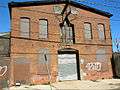 River Street, Fair Haven.
 River Street, Fair Haven.
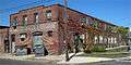 Industrial building now Fairhaven Furniture, River Street and Blatchley Avenue, Fair Haven.
| Topics | |
|---|---|
| Lists by states |
|
| Lists by insular areas | |
| Lists by associated states | |
| Other areas | |
| |
This article is issued from Wikipedia - version of the 11/28/2016. The text is available under the Creative Commons Attribution/Share Alike but additional terms may apply for the media files.