Ribeira de Calhau
| Ribeira de Calhau | |
|---|---|
|
Beach of Calhau | |
 | |
| Coordinates: 16°50′28″N 24°54′04″W / 16.841°N 24.901°WCoordinates: 16°50′28″N 24°54′04″W / 16.841°N 24.901°W | |
| Country | Cape Verde |
| Island | São Vicente |
| Municipality | São Vicente |
| Civil parish | Nossa Senhora da Luz |
| Population (2010)[1] | |
| • Total | 1,177 |
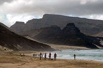
Ribeira de Calhau is a settlement in the eastern part of the island of Sao Vicente, Cape Verde. Its 2010 population was 1,177. It takes its name from the river Ribeira do Calhau, and comprises the villages of Madeiral, Chã de Madeiral, Madeiral do Norte (km 11), Bairro Branco, Calhau Interior (km 13) and Ribeira de Calhau and Calhau, all located near the river, other includes Santa Luzia, an abandoned settlement on Santa Luzia island, the area also includes Ilhéu Branco and Ilhéu Raso. 3 km south of Calhau is the extinct volcanic crater Viana. Also just south of the settlement of Madeiral is a honomymous mountain elevating 675 meters, that part forms a part of Monte Verde Natural Park [2]in which the western part is included but not the agricultural portion.
The population has been growing since the 1960s, its houses are concentrated in Calhau and Madeiral parts and parts west of Calhau within the main road, houses and buildings along with farmlands and plantations are predominantly sporadically located within Ribeira do Calhau as the numbers increased, hotels and some villas now appear 1 km south of the center of Ribeira de Calhau. The road with the north of the island opened in 2013 and forms a new road with a rotary circle at the junction and forms the termini of the Mindelo-Calhau and Salamansa-Calhau Roads.
The Cape Verde Atmospheric Observatory "Humberto Duarte Fonseca" is situated 1 km north of Calhau. It is part of a German-UK initiative to undertake long-term ground- and ocean-based observations in the tropical Eastern North Atlantic Ocean region.[3]
Climate
Calhau has a mild and dry tropical climate like most of the island, the average annual temperature is 24.8 °C, more than a degree warmer than the island capital. . The average temperature is 18 to 27 °C (64–81 °F), the highest is 26.9 °C in August and the lowest is 18.6 °C in February. Average rainfall is 129 millimeters, the highest is 67 mm in September and the lowest is without a single precipitation between the months of April and June.
| Climate data for Calhau, 10-40 metres ASL | |||||||||||||
|---|---|---|---|---|---|---|---|---|---|---|---|---|---|
| Month | Jan | Feb | Mar | Apr | May | Jun | Jul | Aug | Sep | Oct | Nov | Dec | Year |
| Average high °C (°F) | 23.0 (73.4) |
22.4 (72.3) |
23.2 (73.8) |
23.7 (74.7) |
24.1 (75.4) |
25.2 (77.4) |
26.7 (80.1) |
26.9 (80.4) |
26.3 (79.3) |
25.8 (78.4) |
25.8 (78.4) |
24.1 (75.4) |
24.8 (76.6) |
| Daily mean °C (°F) | 20.8 (69.4) |
20.5 (68.9) |
20.9 (69.6) |
21.3 (70.3) |
21.7 (71.1) |
23.0 (73.4) |
24.1 (75.4) |
24.7 (76.5) |
24.7 (76.5) |
24.3 (75.7) |
23.6 (74.5) |
22.1 (71.8) |
22.6 (72.7) |
| Average low °C (°F) | 18.7 (65.7) |
18.6 (65.5) |
18.7 (65.7) |
18.9 (66) |
19.4 (66.9) |
20.8 (69.4) |
21.5 (70.7) |
22.6 (72.7) |
23.2 (73.8) |
22.8 (73) |
21.5 (70.7) |
20.2 (68.4) |
20.6 (69.1) |
| Average precipitation mm (inches) | 5 (0.2) |
1 (0.04) |
1 (0.04) |
0 (0) |
0 (0) |
0 (0) |
4 (0.16) |
19 (0.75) |
67 (2.64) |
17 (0.67) |
10 (0.39) |
5 (0.2) |
129 (5.08) |
| Source: Climate-Data.ORG | |||||||||||||
References
- ↑ "2010 Census results". Instituto Nacional de Estatística Cabo Verde (in Portuguese). 17 March 2014.
- ↑ Áreas protegidas, Cabo Verde (Portuguese)
- ↑ Cape Verde Atmospheric Observatory
Bibliography
- Michel Lesourd, "Calhau", Le Cap-Vert, Jaguar Publishers, Paris, 2006, p. 212 ISBN 978-2-86950-408-0
The island of São Vicente and the surrounding islands | ||
|---|---|---|
| Communities and settlements |  | |
| Parish | ||
| Mountains |
| |
| Streams |
| |
| Surrounding islet | ||
| Other geographical features |
| |
| Culture
| ||