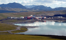
Red Dog Mine, Alaska
| Red Dog Mine, Alaska | |
|---|---|
| Census-designated place | |
 | |
 Location in Northwest Arctic Borough and the state of Alaska. | |
| Coordinates: 68°4′19″N 162°52′34″W / 68.07194°N 162.87611°WCoordinates: 68°4′19″N 162°52′34″W / 68.07194°N 162.87611°W | |
| Country | United States |
| State | Alaska |
| Borough | Northwest Arctic |
| Government | |
| • Borough mayor | Reggie Joule[1] |
| • State senator | Donald Olson (D) |
| • State rep. | Benjamin Nageak (D) |
| Area | |
| • Total | 66.9 sq mi (173.2 km2) |
| • Land | 66.9 sq mi (173.2 km2) |
| • Water | 0.0 sq mi (0.0 km2) |
| Elevation | 853 ft (260 m) |
| Population (2010)[2] | |
| • Total | 309 |
| • Density | 4.6/sq mi (1.8/km2) |
| Time zone | Alaska (AKST) (UTC-9) |
| • Summer (DST) | AKDT (UTC-8) |
| Area code(s) | 907 |
| FIPS code | 02-64980 |
| GNIS feature ID | 1865564 |
| Website | www.reddogalaska.com |
Red Dog Mine is a census-designated place (CDP) in the Northwest Arctic Borough of the U.S. state of Alaska. The population was 309 at the 2010 census.
Economy
The Red Dog mine is the only economic activity and the mine is the only inhabited site within the Red Dog Mine CDP.[3]
Mining
The Red Dog Mine CDP derives its name from the Red Dog mine, the world's largest source for zinc and a significant source of lead. Construction of the Red Dog mine began in 1987, after exploration revealed that the area was rich in metals.[4][5]
The Red Dog ore body is one of the world's most significant zinc deposits, containing a number of ore bodies. The mine is located in Alaska's Northwest Arctic Borough, in the DeLong Mountains of the western Brooks Range, 90 miles north of Kotzebue and 55 miles from the Chukchi Sea.
At the end of 2007, the site's proven and probable reserves plus indicated resources amounted to 77.5 million tons, containing 17.5 percent zinc and 4.8 percent lead, as well as 2.8 ounces per ton of silver. In addition, Red Dog also contains 36.6 million tons of inferred resources. The entire deposit lies inside a relatively small area (one mile by one-half mile). The deposit is essentially flat-lying at the surface, making open pit mining the extraction method of choice.
Geography
Red Dog Mine is located at 68°04′19″N 162°52′34″W / 68.071989°N 162.876044°W.[6] It is in the DeLong Mountains in the remote western Brooks Range about 90 miles (140 km) north of Kotzebue and 55 miles (89 km) from the Chukchi Sea.
Red Dog Mine is very isolated. It is located within the Northwest Arctic Borough, an area approximately the size of Indiana with only 11 communities, none connected by roads, with a total population of only 7,208 people at the 2000 census. The nearest of those communities are Noatak, population 428, roughly 50 miles (80 km) south and Kivalina, population 377, roughly 60 miles (100 km) west at the 2000 census.[7]
Although native populations have historically used the nearby area for seasonal food-gathering, there are no permanent residents at the mine or the port site. The mine's workforce consists of about 460 employees and contractors, of which somewhat more than half will be on-site at any given time. At the mine, everyone stays in the single large housing unit, tucked in among the process buildings near the edge of the open pit, while a small portion of the work force stays at the port site.[8]
According to the United States Census Bureau, the CDP has a total area of 66.9 square miles (173 km2), all land.
Demographics
As of the census of 2000,[7] there were 32 people, 0 households, and 0 families residing in the CDP. The population density was 0.5 people per square mile (0.2/km²). There were 0 housing units. The racial makeup of the CDP was 31.25% White, 65.62% Native American, and 3.12% from two or more races.
In the CDP the age distribution of the population shows 18.8% from 18 to 24, 62.5% from 25 to 44, and 18.8% from 45 to 64. The median age was 34 years. For every 100 females there were 700.0 males. For every 100 females age 18 and over, there were 700.0 males.
The median income for both males and females in the CDP was $0. The per capita income for the CDP was $34,438. 37.9% of the population were living below the poverty line.
Transportation
A 52-mile (84 km) long haul road connects the mine to the mine's port site on the Chukchi Sea. The region is accessible only by air, served by the Red Dog Airport, except during the 100-day shipping season. Mine workers from remote villages in the region are ferried to the mine on small aircraft. Alaska Airlines is contracted by the mine to fly other mine workers out of Anchorage.
References
- ↑ "Community: Northwest Arctic Borough". Community Database Online. Juneau: Alaska Department of Commerce, Community and Economic Development, Division of Community and Regional Affairs. 2013. Retrieved June 4, 2013.
- ↑ "2010 City Population and Housing Occupancy Status". U.S. Census Bureau. Retrieved May 14, 2012.
- ↑ http://www.akaction.org/REPORTS/Red_Dog_Report/ACATRedDogReportFinal.pdf
- ↑ Alaska Resource Data File, USGS Open File 00-23, p.2.
- ↑ D.J. Szumigala, Alaska, Mining Engineering, May 2007, p.66.
- ↑ "US Gazetteer files: 2010, 2000, and 1990". United States Census Bureau. 2011-02-12. Retrieved 2011-04-23.
- 1 2 "American FactFinder". United States Census Bureau. Retrieved 2008-01-31.
- ↑ Operation and Site Performance 2006, Red Dog Mine, Teck Cominco Ltd.
External links
Municipalities and communities of Northwest Arctic Borough, Alaska, United States | ||
|---|---|---|
| Cities | 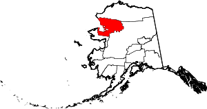 | |
| CDPs | ||
| Unincorporated communities | ||
| Ghost towns | ||