Rauch, Minnesota
| Rauch, Minnesota | |
|---|---|
| Unincorporated community | |
 Rauch, Minnesota  Rauch, Minnesota Location of the community of Rauch | |
| Coordinates: 47°57′32″N 93°08′45″W / 47.95889°N 93.14583°WCoordinates: 47°57′32″N 93°08′45″W / 47.95889°N 93.14583°W | |
| Country | United States |
| State | Minnesota |
| County | Koochiching |
| Elevation | 1,283 ft (391 m) |
| Time zone | Central (CST) (UTC-6) |
| • Summer (DST) | CDT (UTC-5) |
| ZIP code | 55771 |
| Area code(s) | 218 |
| GNIS feature ID | 654898[1] |
Rauch is an unincorporated community in Koochiching County, Minnesota, United States.
The community is located between Togo and Orr at the junction of County Road 75 (CR 75) and State Highway 65 (MN 65).
Rauch is located in the southeast corner of the county. The boundary line between Koochiching, Saint Louis, and Itasca counties is nearby. Rauch is located within ZIP code 55771 based in Orr.
Geography
Rauch is located in South Koochiching Unorganized Territory.
Nearby places include Silverdale, Greaney, Celina, Togo, Nett Lake, and Orr. Rauch is located 24 miles southwest of Orr; and 14 miles north of Togo. Rauch is 28 miles northwest of Cook; and 67 miles south of International Falls.
The Little Fork River flows through the community. The Willow River, a tributary of the Little Fork River, is also in the vicinity.
References
- Rand McNally Road Atlas – 2007 edition – Minnesota entry
- Official State of Minnesota Highway Map – 2011/2012 edition
- Mn/DOT map of Koochiching County – Sheet 2 – 2011 edition
Municipalities and communities of Koochiching County, Minnesota, United States | ||
|---|---|---|
| Cities | 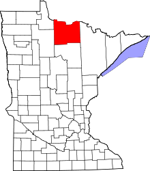 | |
| Unorganized territories | ||
| Unincorporated communities | ||
| Indian reservations | ||
| Ghost towns | ||
| Footnotes | ‡This populated place also has portions in an adjacent county or counties | |