Rafael Uribe Uribe, Bogotá
| Rafael Uribe Uribe | |
|---|---|
| Locality of Bogotá | |
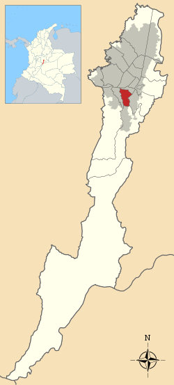
 Location of the locality in the city of Bogotá | |
 Location of the locality in the Capital District of Bogotá | |
| Country |
|
| City | Bogotá D.C. |
| Neighbourhoods |
List
|
| Area | |
| • Total | 13.83 km2 (5.34 sq mi) |
| Elevation | 2,600 m (8,500 ft) |
| Population (2007)[1] | |
| • Total | 378,780 |
| • Density | 27,000/km2 (71,000/sq mi) |
| Time zone | Colombia Standard Time (UTC-5) |
| Website | Official website |
The Rafael Uribe Uribe is the 18th locality of the Capital District in the Colombian capital city Bogotá. It was named after the Liberal General Rafael Uribe Uribe. Historically it has been predominantly a residential area with a very small commercial activity. Since the 1940s urban expansion began from the plane lands to the higher lands. Nowadays the locality's southern part is underoing an urban expansion.
Geography
The Rafael Uribe Uribe Locality borders to the north with the Avenida Primero de Mayo and with the locality of Antonio Nariño, to the south with 46th, 47th and 54 south and Via Usme streets by the locality of Usme. To the east the locality borders with Carrera 10 and the Chiguaza Creek by the locality of San Cristóbal and to the west with the Avenida 27 South and Carrera 33 bordering with the locality of Tunjuelito.
History
In 1991 the territory of Rafael Uribe Uribe became a locality and in 1993 the Local Cityhall was constituted. On October 29, 2004 the Quiroga neighborhood was subject to a terrorist attack.
Transport
Besides the routes covered by private bus companies the area is covered by the mass-transit system TransMilenio with its H Line covering most of the area with the stops; Consuelo, Socorro, Santa Lucía, Calle 40 Sur, Quiroga and Olaya.
Neighborhoods
La Picota (where there is a prison with the same name), Quiroga (where the local cityhall is), Diana Turbay, Molinos, Libertador, Olaya, Gustavo Restrepo, Santa Lucia, Inglés, La Resurrección, Sosiego, Claret, San Jorge, Marco Fidel Suarez, El Pesebre, Río de Janeiro, Las Colinas, Luis López de MMeza, Terrazas de San Jorge, Molinos Sur, Bochica, Marruecos, Socorro, Puerto Rico, Pijaos, Las Lomas, Mirador, Bosque de San Carlos and Country Sur, los pinos, libertadores, among others.
References
- ↑ (Spanish) Population 2007 - DANE
External links
- 18th locality website; Rafael Uribe Uribe
- Bogotá official website
- National University of Colombia; Rafael Uribe Uribe
 | Administrative subdivision in 19 localities | 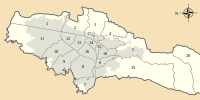 | |
|---|---|---|---|
| Metropolitan Area | |||
| Geography | |||
| |||
Coordinates: 4°34′47″N 74°07′03″W / 4.57972°N 74.11750°W