San Cristóbal, Bogotá
| San Cristóbal | |
|---|---|
| Locality of Bogotá | |
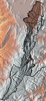
 Location of the locality in the city of Bogotá | |
 Location of the locality in the Capital District of Bogotá | |
| Country |
|
| City | Bogotá D.C. |
| Neighbourhoods | |
| Area | |
| • Total | 49.09 km2 (18.95 sq mi) |
| Elevation | 2,600 m (8,500 ft) |
| Population (2007)[1] | |
| • Total | 404,350 |
| • Density | 8,200/km2 (21,000/sq mi) |
| Time zone | Colombia Standard Time (UTC-5) |
| Website | Official website |
San Cristóbal, (English: Saint Christopher) is the fourth locality of Bogotá, capital of Colombia. It is located in the south-east of the city.
General information
Borders
North: Santa Fe locality.
South: The locality of Usme.
East: The municipality of Ubaque, Cundinamarca.
West: The localities of Los Mártires and Antonio Nariño.
Hydrology
The Fucha river's source lies within the locality and is known as the San Cristóbal river while running through the locality's borders.
Topography
Bogotá's southeastern corner, including eastern San Cristóbal, rise into the city's eastern mountain range. The western side of the locality is relatively flat.
Transportation
The main transit artery is Calle 22 south, which is also known as Avenida Primero de Mayo. Other important roads are Calle 11 South, the Eastern Highway which connects the municipalities located to Bogotá's southeast, Carrera 10, and the extension of Avenida Circunvalar in the eastern hills.
Points of interest
- Divino Niño (Divine Child) church, located in the Veinte de Julio neighborhood.
- San Cristóbal and Gaitán Cortés (Columnas Park) metropolitan parks
- The Entrenubes (between clouds) nature park
- The Primer de Mayo bike track
- La Victoria community center, which has a pool and cultural center
Neighborhoods
The neighborhoods of San Cristóbal are:
San Cristóbal, Barcelona, Columnas, Corinto, La Castaña, La Gran Colombia, La María, Montecarlo, Quinta Ramos, San Pedro, Aguas Claras, La Belleza, Buenos Aires, Canadá, El Triángulo, Granada Sur, Juan Rey, La Victoria, Las Mercedes, Los Alpes, Los Libertadores, Malvinas, Nariño Sur, Los Pinares, Quindío, Ramajal, Sagrada Familia, San Blas, San Isidro, San José Sur Oriental, Santa Inés Sur Oriental , Sociego, Suramérica, La Gloria, Veinte de Julio, Villa de los Alpes, Villa Javier, Vitelma.
References
- ↑ (Spanish) Population 2007 - DANE
External links
- (Spanish) National University of Colombia site about San Cristóbal.
- (Spanish) Document with general data about the locality
 | Administrative subdivision in 19 localities | 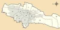 | |
|---|---|---|---|
| Metropolitan Area | |||
| Geography | |||
| |||
Coordinates: 4°33′53″N 74°05′00″W / 4.56472°N 74.08333°W