Rémigny, Quebec
| Rémigny | |
|---|---|
| Municipality | |
 | |
 Location within Témiscamingue RCM. | |
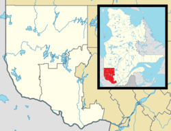 Rémigny Location in western Quebec. | |
| Coordinates: 47°46′N 79°12′W / 47.767°N 79.200°WCoordinates: 47°46′N 79°12′W / 47.767°N 79.200°W[1] | |
| Country |
|
| Province |
|
| Region | Abitibi-Témiscamingue |
| RCM | Témiscamingue |
| Settled | 1935 |
| Constituted | January 1, 1978 |
| Government[2] | |
| • Mayor | Jocelyn Aylwin |
| • Federal riding | Abitibi—Témiscamingue |
| • Prov. riding | Rouyn-Noranda–Témiscamingue |
| Area[2][3] | |
| • Total | 990.70 km2 (382.51 sq mi) |
| • Land | 896.29 km2 (346.06 sq mi) |
| Population (2011)[3] | |
| • Total | 279 |
| • Density | 0.3/km2 (0.8/sq mi) |
| • Pop (2006–11) |
|
| • Dwellings | 154 |
| Time zone | EST (UTC−5) |
| • Summer (DST) | EDT (UTC−4) |
| Postal code(s) | J0Z 3H0 |
| Area code(s) | 819 |
| Website |
www remigny |
Rémigny is a municipality in northwestern Quebec, Canada, in the Témiscamingue Regional County Municipality.
History
In 1920, the geographic township of Rémigny was formed, named after Captain Rémigny of the La Sarre Regiment, who was made a Knight of the Order of Saint Louis in 1759 and captain of Grenadier Company in 1760. The community had its start in 1935 when sixty settlers from Joliette arrived on the northern shores of Barrière Bay of Lake Des Quinze as part of the Vautrin Settlement Plan. In 1978, the place was incorporated and named after the township.[1]
Demographics
Population trend:[4]
- Population in 2011: 279 (2006 to 2011 population change: -12.3 %)
- Population in 2006: 318
- Population in 2001: 367
- Population in 1996: 364
- Population in 1991: 381
Private dwellings occupied by usual residents: 135 (total dwellings: 154)
Mother tongue:[5]
- English as first language: 12.5%
- French as first language: 83.9%
- English and French as first language: 0%
- Other as first language: 3.6%
Climate
| Climate data for Rémigny | |||||||||||||
|---|---|---|---|---|---|---|---|---|---|---|---|---|---|
| Month | Jan | Feb | Mar | Apr | May | Jun | Jul | Aug | Sep | Oct | Nov | Dec | Year |
| Record high °C (°F) | 7.2 (45) |
11 (52) |
19 (66) |
29.1 (84.4) |
32.2 (90) |
35 (95) |
37.8 (100) |
36.1 (97) |
31.1 (88) |
25 (77) |
17.8 (64) |
14.5 (58.1) |
37.8 (100) |
| Average high °C (°F) | −9.8 (14.4) |
−7.2 (19) |
−0.7 (30.7) |
7.7 (45.9) |
16.9 (62.4) |
21.7 (71.1) |
24.1 (75.4) |
22.6 (72.7) |
16.7 (62.1) |
9.5 (49.1) |
0.9 (33.6) |
−6.5 (20.3) |
8 (46) |
| Daily mean °C (°F) | −16.5 (2.3) |
−14.3 (6.3) |
−7.5 (18.5) |
1.6 (34.9) |
10 (50) |
14.8 (58.6) |
17.5 (63.5) |
16.3 (61.3) |
11 (52) |
4.9 (40.8) |
−3.1 (26.4) |
−12.2 (10) |
1.9 (35.4) |
| Average low °C (°F) | −23.1 (−9.6) |
−21.4 (−6.5) |
−14.2 (6.4) |
−4.6 (23.7) |
3 (37) |
7.8 (46) |
10.9 (51.6) |
9.8 (49.6) |
5.3 (41.5) |
0.2 (32.4) |
−7.1 (19.2) |
−17.8 (0) |
−4.3 (24.3) |
| Record low °C (°F) | −46 (−51) |
−47 (−53) |
−40 (−40) |
−27.8 (−18) |
−9.4 (15.1) |
−6.7 (19.9) |
−2 (28) |
−2 (28) |
−7 (19) |
−12.8 (9) |
−35 (−31) |
−47 (−53) |
−47 (−53) |
| Average precipitation mm (inches) | 55 (2.17) |
42.7 (1.681) |
60.4 (2.378) |
60.5 (2.382) |
83.3 (3.28) |
92 (3.62) |
91.8 (3.614) |
101.9 (4.012) |
102.7 (4.043) |
85.9 (3.382) |
76.3 (3.004) |
63.4 (2.496) |
915.9 (36.059) |
| Source: Environment Canada[6] | |||||||||||||
See also
References
- 1 2 "Rémigny (Municipalité)" (in French). Commission de toponymie du Québec. Retrieved 2011-01-04.
- 1 2 "Rémigny". Répertoire des municipalités (in French). Ministère des Affaires municipales, des Régions et de l'Occupation du territoire. Retrieved 2011-01-04.
- 1 2 "Rémigny census profile". 2011 Census data. Statistics Canada. Retrieved 2011-01-04.
- ↑ Statistics Canada: 1996, 2001, 2006, 2011 census
- ↑ "Rémigny community profile". 2006 Census data. Statistics Canada. Retrieved 2011-01-04.
- ↑ Environment Canada Canadian Climate Normals 1971–2000, accessed 14 July 2010
 |
Rouyn-Noranda | | ||
| Nédélec | |
Rouyn-Noranda | ||
| ||||
| | ||||
| Guérin | Angliers, Moffet | Laforce |
| Cities | |
|---|---|
| Municipalities | |
| Townships |
|
| Parishes | |
| Villages | |
| Unorganized territories | |
| |
This article is issued from Wikipedia - version of the 2/23/2014. The text is available under the Creative Commons Attribution/Share Alike but additional terms may apply for the media files.