Duhamel-Ouest
| Duhamel-Ouest | |
|---|---|
| Municipality | |
|
Fort Temiscamingue | |
 Location within Témiscamingue RCM. | |
 Duhamel-Ouest Location in western Quebec. | |
| Coordinates: 47°22′N 79°26′W / 47.367°N 79.433°WCoordinates: 47°22′N 79°26′W / 47.367°N 79.433°W[1] | |
| Country |
|
| Province |
|
| Region | Abitibi-Témiscamingue |
| RCM | Témiscamingue |
| Settled | 1870s |
| Constituted | February 20, 1911 |
| Government[2] | |
| • Mayor | Alain Sarrazin |
| • Federal riding | Abitibi—Témiscamingue |
| • Prov. riding | Rouyn-Noranda–Témiscamingue |
| Area[2][3] | |
| • Total | 128.20 km2 (49.50 sq mi) |
| • Land | 91.78 km2 (35.44 sq mi) |
| Population (2011)[3] | |
| • Total | 828 |
| • Density | 9.0/km2 (23/sq mi) |
| • Pop (2006–11) |
|
| • Dwellings | 419 |
| Time zone | EST (UTC−5) |
| • Summer (DST) | EDT (UTC−4) |
| Postal code(s) | J9V 1A2 |
| Area code(s) | 819 |
Duhamel-Ouest is a municipality in northwestern Quebec, Canada in the Témiscamingue Regional County Municipality.
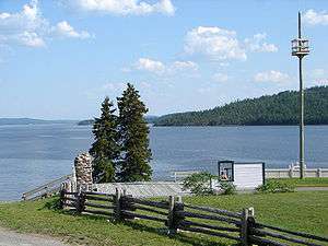
Located at a narrows of Lake Timiskaming, Duhamel-Ouest is home to the Fort Témiscamingue, a National Historic Site of Canada.
Demographics
Population trend:[4]
- Population in 2011: 828 (2006 to 2011 population change: -4.8 %)
- Population in 2006: 870
- Population in 2001: 766
- Population in 1996: 671
- Population in 1991: 595
Private dwellings occupied by usual residents: 338 (total dwellings: 419)
Mother tongue:[5]
- English as first language: 2.9%
- French as first language: 97.1%
- English and French as first language: 0%
- Other as first language: 0%
See also
References
- ↑ Reference number 19633 of the Commission de toponymie du Québec (French)
- 1 2 "Duhamel-Ouest". Répertoire des municipalités (in French). Ministère des Affaires municipales, des Régions et de l'Occupation du territoire. Retrieved 2010-12-30.
- 1 2 "Duhamel-Ouest census profile". 2011 Census data. Statistics Canada. Retrieved 2010-12-30.
- ↑ Statistics Canada: 1996, 2001, 2006, 2011 census
- ↑ "Duhamel-Ouest community profile". 2006 Census data. Statistics Canada. Retrieved 2010-12-30.
 |
Saint-Bruno-de-Guigues | | ||
| Ville-Marie / Lake Timiskaming Unorganized West Timiskaming District |
|
Lorrainville | ||
| ||||
| | ||||
| Saint-Édouard-de-Fabre | Béarn |
| Cities | |
|---|---|
| Municipalities | |
| Townships |
|
| Parishes | |
| Villages | |
| Unorganized territories | |
| |
This article is issued from Wikipedia - version of the 2/23/2014. The text is available under the Creative Commons Attribution/Share Alike but additional terms may apply for the media files.