Quinnipiac River Historic District
|
Quinnipiac River Historic District | |
|
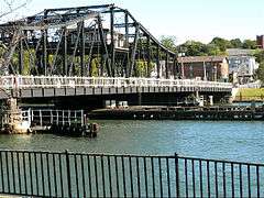
Grand Avenue Bridge (1896). | |
  | |
| Location | East Haven, Connecticut |
|---|---|
| Coordinates | 41°18′35″N 72°52′59″W / 41.30972°N 72.88306°WCoordinates: 41°18′35″N 72°52′59″W / 41.30972°N 72.88306°W |
| Area | 313 acres (127 ha) |
| Architectural style | Greek Revival, Italianate, Queen Anne |
| NRHP Reference # | 84001139[1] |
| Added to NRHP | June 28, 1984 |
Quinnipiac River Historic District is a 313-acre (127 ha) historic district straddling the Quinnipiac River in the Fair Haven and Fair Haven Heights neighborhoods of East Haven, Connecticut. It encompasses most of the historic maritime village of Fair Haven, with a history dating back to the 18th century.[2]
It was listed on the National Register of Historic Places in 1984. At that time it included 524 contributing buildings, an inland wetland at the mouth of Hemingway Creek on the northeast corner of the district, and the Grand Avenue Swing Bridge over the Quinnipiac River connecting Fair Haven with Fair Haven Heights at the center of the district and previously identified as being NRHP-eligible.[1][2]
Gallery
 Original Stephen Rowe’s tavern and store (1804), 182 Front St., and other houses of the early 19th century oystering village on Front St. north of the Grand Ave. Bridge.
 King's Block (1816), 20 Grand Ave.
 Double Greek revival house, 37-39 Grand Avenue.
 One Grand Ave. (1890s)
See also
References
- 1 2 National Park Service (2009-03-13). "National Register Information System". National Register of Historic Places. National Park Service.
- 1 2 Kate Ohno and John Herzan (1983). "National Register of Historic Places Inventory-Nomination: Quinnipia River Historic District" (PDF). National Park Service. and Accompanying 37 photos, from 1983 and historic
External links
- East Haven Preservation Trust: Quinnipiac River Historic District, with text adapted from NRHP application document plus gallery of 8 photos
- Quinnipiac River Village
| Topics | |
|---|---|
| Lists by states |
|
| Lists by insular areas | |
| Lists by associated states | |
| Other areas | |
| |
This article is issued from Wikipedia - version of the 11/28/2016. The text is available under the Creative Commons Attribution/Share Alike but additional terms may apply for the media files.