Puerto Peñasco Municipality
| Puerto Peñasco Municipality | |
|---|---|
| Municipality | |
| Country |
|
| State | Sonora |
| Capital | Puerto Peñasco |
| Population (2010) | |
| • Total | 57,342 |
| Time zone | Mountain Standard Time (UTC-7) |
| • Summer (DST) | None (UTC) |
Puerto Peñasco Municipality is a municipality in Sonora in north-western Mexico.[1] The only locality with a significant population is the municipal seat, also named Puerto Peñasco, which contains almost 99% of the municipality's population (2010 census). Most of the municipality consists of empty stretches of the Gran Desierto de Altar (Altar Desert) adjacent to and south of the international border with Arizona, USA.
Geography
The municipality lies at the northern end of the Gulf of California (Sea of Cortez).
Adjacent municipalities (municipios) and counties
- San Luis Río Colorado Municipality - west
- Caborca Municipality - southeast
- Plutarco Elías Calles Municipality - northeast
- Yuma County, Arizona - northwest
The municipality
As municipal seat, the city of Puerto Peñasco has governing jurisdiction over 27 other named communities,[2] which cover a territory of 9,774.45 km2.[3] The municipality has a total population of 57,342 inhabitants, of whom all but 586 live in the city proper.[2] The municipality borders with the municipalities of San Luis Río Colorado, Plutarco Elías Calles, and Caborca. To its north-northwest is Yuma County, Arizona, in the United States and to the south is the Gulf of California.[3]
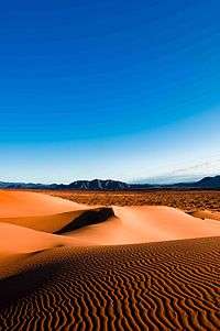
The land is generally flat with the small mountain range of Sonoyta to the north and east of the area. Most of the territory is the Altar Desert, which extends north and east of the city, and a volcanic zone called Sierra El Pinacate.[3][4] The municipality has 110 km of beaches.[5] Near the city are fields of sand dunes of the Altar Desert, which is one of the driest in the world.[3] ATVs and motocross are permitted on the sand dunes.[6] Most vegetation and animal life is typical for sandy deserts, scrub brush, reptiles (including the Gila monster) and small mammals.[3]
Farming and livestock is nearly non-existent due to the dry conditions. Some industry exists, associated with fishing such as canning and freezing. The commercial sector of the economy support 57% of the population selling food, clothes, pharmaceuticals and other items to both the local population and to tourists. The second most important economic sector is fishing, especially shrimp fishing.[3] Tourism drives most of the commercial sector. The municipality receives about 1,000 visitors a day, with about 85% coming from the U.S. state of Arizona.[5]
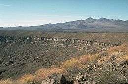
El Pinacate is a volcanic region and a biosphere reserve that covers 714,556.6 hectares which covers parts of the municipalities of Puerto Peñasco, San Luís Río Colorado and Plutarco Elías Calles. This area has been considered one of the most arid and inhospitable of the Sonoran Desert. In spite of this, the area contains a wide variety of wildlife and evidence of human habitation from ancient times, which has attracted the attention of both tourists and researchers. It contains 553 species of plants with cactuses such as saguaros, chollas and ocotillos dominating. With the rainy season, the area explodes with short-lived wildflowers. The area also contains 41 species of mammals, 237 species of birds, 45 species of reptiles, and four types of amphibians. It was declared a protected biosphere reserve by the Mexican government in 1993. The entrance to the biosphere park is located 50 km from the city of Puerto Peñasco. The nucleus of the biosphere consists of the Sierra el Pinacate, Adair Bay and Sierra del Rosario which cannot be developed under any circumstances. The main attraction for tourists is the volcanic craters. The major ones are named Badillo, Molina (or Trébol), McDougal (the largest) and Caravajales. In addition, there is the Grande Volcano which stands at 3,200 feet tall, and has a depth of 950 ft.[7]
San Jorge Island, also known as Bird Island, is really a small group of rocky outcroppings that are just above the surface of the sea about 40 km southeast of the city. The rocks are capped in white like the Alps, not with snow, but with the guano of innumerable sea birds such as seagulls and pelicans, which live here. Below the birds live approximately 3,000 sea lions very close to the water. It is the largest concentration of sea lions in Mexico. It is possible to kayak and/or snorkel here.[4]
Nine native cultures can be found in the municipality. The Guarijíos have a wide variety of crafts such as figures made with natural materials such as palm fronds and clay. They also make hats from a variety of natural fibers. The Mayos, who call themselves the Yoreme, have a rich oral tradition. Other groups include the Opatas, the Papagos, the Pimas, the Seris, the Yaquis, the Cucapa, and the Kikapu, all of whom are noted for basketmaking using desert plants.[8]
References
- ↑ "-". Enciclopedia de los Municipios de México. Instituto Nacional para el Federalismo y el Desarrollo Municipal. Retrieved January 4, 2010.
- 1 2 "INEGI Census 2010".
- 1 2 3 4 5 6 "Enciclopedia de los Municipios de México Sonora Puerto Peñasco" (in Spanish). Mexico: INAFED. Retrieved December 15, 2009.
- 1 2 Romo Cedano, Luis (June 2007). "Puerto Peñasco: Mar y desierto al extremo" [Puerto Peñasco:Sea and desert to the extreme]. Revista Travesias (in Spanish). Mexico. Retrieved December 15, 2009.
- 1 2 "Destinos de Sonora-Puerto Peñasco" [Sonora Destinations – Puerto Peñasco] (in Spanish). Mexico: Government of Sonora. Retrieved 2009-12-15.
- ↑ "Sobre Puerto Peñasco" [About Puerto Peñasco] (in Spanish). Mexico: Explorando Mexico. Retrieved 2009-12-15.
- ↑ "El Pinacate y Gran Desierto de Altar - Reservas Ecológicas de Sonora" [El Pinacate and the Great Altar Desert – Ecological Reserves of Sonora] (in Spanish). Mexico: Government of Sonora. Retrieved 2009-12-15.
- ↑ "Puerto Peñasco" (in Spanish). Buen Viaje Diario Turistico on line. Retrieved 2009-12-15.

Coordinates: 31°24′34″N 113°14′55″W / 31.4095°N 113.2486°W