Álamos
| Álamos | |
|---|---|
 | |
|
Álamos Location in Mexico | |
| Coordinates: 27°1′39″N 108°56′24″W / 27.02750°N 108.94000°W | |
| Country |
|
| State | Sonora |
| Municipality | Álamos |
| Founded | Late 17th century |
| Population (2005[1]) | |
| • Total | 24,493 |
| Time zone | MST (UTC-7) |
| Postal code | 85760 |
| Area code(s) | 647 |

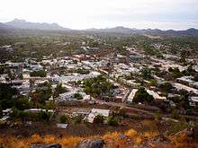
Álamos (Spanish ![]() ['alamos] is a town in Álamos Municipality in the Mexican state of Sonora, in northwestern Mexico.
['alamos] is a town in Álamos Municipality in the Mexican state of Sonora, in northwestern Mexico.
Name
The Municipality of Álamos derives its name from the Álamo tree. Several impressive specimens are found in one of its two principal plazas, the Alameda. The nearby pueblito, El Sabinito, located within the Municipality, likewise derives its name from a tree, the Sabino.
History
The area was named by the conquistador Francisco Vásquez de Coronado . His expedition of 1540 camped at the confluence of the two major arroyos (Escondido and the Aduana) of present-day Alamos and made reference to local geographical landmarks, including two large rock formations on Mt. Alamos, Los Frailes or 'the monks' in English. The church records date to 1682 and the village was incorporated in 1685. Alamos became the capital of the then state of Occidental in the early 1800s, which encompassed today's state of Sonora, the northern portion of the state of Sinaloa, as well as some of the Baja California and southern Arizona. . Álamos was the northern-most “Silver City” in Mexico and although it has much in common, architecturally, with Mexico's other “Silver Cities” it has not succumbed to large-scale commercialism and has managed to retain the charm and pace of earlier times.
A major expedition departed Alamos in 1775, led by Juan Bautista de Anza II to discover a route to Alta California, and creating the Presidio of Monterey. The Anza expedition had nearly 300 members, of which about half were from Alamos. The trek was heavily financed by the wealthy silver mine owners of Alamos.
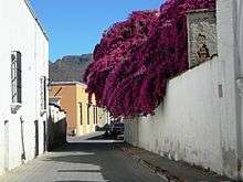
Álamos is known as “La Ciudad de los Portales” (portales are tall, arched, covered verandas or walkways fronting many of the cobble-stoned streets or calles). Álamos boasts numerous buildings exhibiting classic Andalusian architecture from Mexico's Colonial period, including numerous mansions, the Plaza de Armas, the Church of La Purísima Concepción, La Capilla and the Palacio Municipal (“city hall”).

The great wealth created by the silver mines from the surrounding mining towns of La Aduana, Minas Nuevas and San Bernardo enabled the founders and residents of Álamos to build scores of colonial Spanish mansions throughout the town; most of which went into ruin in the early 20th Century until the late 1940s, when a gradual restoration process began, by Americans and Canadians, which is still ongoing today.
Geography and climate
Álamos is located in the southeastern part of Sonora, and 396 km (246 mi) from state capital Hermosillo, 54 km (34 mi) from Navojoa via Sonora State Highway 162, and 663 km (412 mi) from the northern border town of Nogales. It is adjoined by the State of Chihuahua on the east, and the State of Sinaloa on the south. The population of the municipality is 24,493 and its area is 6,947.27 square kilometres or 2,682 square miles.
Álamos has a semi-arid climate (Köppen BSh) bordering on a tropical savanna climate, with three seasons: a hot, dry season from April to June, a hot, humid wet season from July to October, and a warm, generally dry “winter” from November to March. Occasionally the dry winter pattern is interrupted by the passage of frontal cloudbands: 220 millimetres (8.66 in) fell during January 1981, including 168 millimetres (6.61 in) between the fifth and the seventh of that month, and over 120 millimetres (4.72 in) in January 1979.[2] During the hot early summer, temperatures can reach extreme heights; the record being 49.5 °C (121.1 °F) on 16 June 1976.
| Climate data for Álamos (1951-2010) | |||||||||||||
|---|---|---|---|---|---|---|---|---|---|---|---|---|---|
| Month | Jan | Feb | Mar | Apr | May | Jun | Jul | Aug | Sep | Oct | Nov | Dec | Year |
| Record high °C (°F) | 41.5 (106.7) |
44.0 (111.2) |
44.0 (111.2) |
43.0 (109.4) |
48.0 (118.4) |
49.5 (121.1) |
45.5 (113.9) |
44.0 (111.2) |
46.0 (114.8) |
43.0 (109.4) |
39.0 (102.2) |
39.0 (102.2) |
49.5 (121.1) |
| Average high °C (°F) | 27.8 (82) |
28.8 (83.8) |
30.2 (86.4) |
32.5 (90.5) |
35.2 (95.4) |
38.0 (100.4) |
36.2 (97.2) |
35.1 (95.2) |
35.2 (95.4) |
34.4 (93.9) |
31.7 (89.1) |
28.6 (83.5) |
32.8 (91) |
| Average low °C (°F) | 9.2 (48.6) |
9.5 (49.1) |
10.2 (50.4) |
11.6 (52.9) |
14.1 (57.4) |
18.2 (64.8) |
19.8 (67.6) |
20.1 (68.2) |
18.4 (65.1) |
15.2 (59.4) |
11.5 (52.7) |
9.5 (49.1) |
13.9 (57) |
| Record low °C (°F) | 0.0 (32) |
−4 (25) |
2.0 (35.6) |
5.0 (41) |
6.5 (43.7) |
8.0 (46.4) |
9.0 (48.2) |
9.5 (49.1) |
1.3 (34.3) |
6.5 (43.7) |
0.4 (32.7) |
0.0 (32) |
−4 (25) |
| Average rainfall mm (inches) | 35.0 (1.378) |
17.9 (0.705) |
17.8 (0.701) |
1.9 (0.075) |
3.9 (0.154) |
25.5 (1.004) |
184.4 (7.26) |
198.2 (7.803) |
86.3 (3.398) |
53.1 (2.091) |
26.3 (1.035) |
37.0 (1.457) |
687.3 (27.061) |
| Average rainy days (≥ 0.1 mm) | 2.4 | 1.4 | 1.2 | 0.3 | 0.4 | 2.2 | 12.8 | 11.0 | 6.8 | 3.1 | 1.6 | 2.2 | 45.4 |
| Source: Servicio Meteorólogico Nacional[3] | |||||||||||||
Economy
The economy of Álamos, after a heyday lasting from the late 1600s until the early 1900s with the closing of the mines, went into decline. Only a few hundred people remained in the once vibrant city due to a major decline in silver prices, ongoing unrest in the country with a revolution in progress and the exodus of business owners and people of wealth. Vacant mansions went into disrepair until foreigners began restoring homes in 1946 after three decades of abandonment, thus employing locals with building and housekeeping skills. The areas top industry for decades was both ranching and tourism. The present day economy once again has mining as an important factor too with both copper and silver mines operating. About 16 km to the northwest is the Adolfo Ruiz Cortinez Dam and Reservoir known as “El Mocúzarit”, whose waters irrigate 80,000 acres (320 km2). Cattle ranching is seasonal and declining due to impoverished grazing lands. Numerous chicken and pig farms, called “granjas,” contribute substantially to the economy.
Tourism
Álamos was named a “Pueblo Mágico” in 2005. “Pueblo Magico” is a designation given by the Mexican Secretariat of Tourism to towns that offer a 'magical' experience by reason of their natural beauty, cultural riches and historical relevance.

Many Festivals and fiestas occur in Álamos year-round, most notably the Festival of Dr. Alfonso Ortiz Tirado (“FAOT”), attended by many national and international musicians, and celebrities. Dr. Alfonso Ortiz Tirado, born in this community in 1894, achieved recognition for being “El Tenor de las Américas.” An impressive exhibit of Ortiz Tirado is found in the Museo Costumbrista, located in front of and to the east of the Plaza de Armas. The annual Festival Alfonso Ortiz Tirado is a nine-day event that takes places in Álamos annually in late January. Also, there is an annual film festival, usually held in March of each year. Several professional hunting lodges operate in the Alamos area attracting dove hunters from various areas of the world. In the last decade filming has taken place for one European Endemol production as well as more than 180 episodes of Mexico's all time number one 'novela' (soap opera), 'La Fuerza del Destino'.
The Sierra de Álamos Ecological Reserve, offers serious “birding” opportunities. The creek of Cuchujaqui, which is in the ecological reserve is the most species-rich subtropical area in the Northern Hemisphere. Cuchujaqui is the subject of international scientific study and the southern migration destination of hundreds of different species of birds.
The presence of a jet rated airport in Alamos (XALA) is a key factor in attracting aviators from Mexico, the US and Canada on a regular basis. There is also charter service available to some areas of the Copper Canyon. The village has more than 20 hotels and B&B's, including a AAA Four Diamond resort.
Notable residents
- María Félix, film actress
- Gloria Fonda, silent film actress (died in Álamos in 1978)
- Arturo Márquez, composer
- Alfonso Ortiz Tirado, physician, tenor, and philanthropist
- Félix María Zuloaga, former President of Mexico
Sister cities
Planet Mars
The name Álamos has been used for a crater on the planet Mars by the International Astronomical Union, although not specifically commemorating the town.[4]
References
- ↑ (Spanish) 2005 census, INEGI.
- ↑ Servicio Meteorólogico Nacional; CLIMATOLOGÍA ESTADÍSTICA: Álamos
- ↑ "ESTACION: 00026002 ALAMOS". Servicio Meteorólogico Nacional. 2012. Retrieved on May 12, 2015.
- ↑ Categories for Naming Features on Planets and Satellites, Gazetteer of Planetary Nomenclature, USGS Astrogeology Science Center, NASA
External links
| Wikivoyage has a travel guide for Álamos. |
- H. Ayuntamiento de Álamos (Official WebSite of Álamos, Sonora)
- Turismo Sonora
- Álamos Sonora Mexico
- Álamos Sonora Mexico Expatriate Community Forum
| Wikimedia Commons has media related to Álamos, Sonora. |
Coordinates: 27°01′39″N 108°56′24″W / 27.02750°N 108.94000°W