Pinacate Peaks
| Pinacate Peaks (Sierra Pinacate) | |
| Volcano (Mountain Range) | |
| Country | Mexico |
|---|---|
| State | Sonora |
| Region | (north-central)-Sonoran Desert El Pinacate y Gran Desierto de Altar |
| Municipality | Puerto Peñasco, Sonora |
| Borders on | Gran Desierto de Altar-(west) Mexican Federal Highway 8-SE |
| Coordinates | 31°46′N 113°29′W / 31.77°N 113.49°WCoordinates: 31°46′N 113°29′W / 31.77°N 113.49°W |
| Highest point | Cerro del Pinacate (Volcan Santa Clara) |
| - elevation | 3,904 ft (1,190 m) |
| Length | 41 mi (66 km), N-S |
| Width | 30 mi (48 km), E-W |
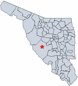 location of Sierra Pinacate in Sonora | |
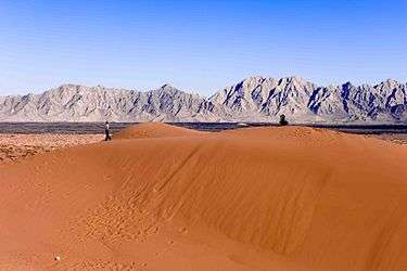

The Pinacate Peaks (Sierra Pinacate, O'odham: Cuk Doʼag) are a volcanic group of volcanic peaks and cinder cones located mostly in the Mexican state of Sonora along the international border adjacent to the U.S. state of Arizona, surrounded by the vast sand dune field of the Gran Desierto de Altar, at the desert's southeast.[1]
The Spanish name for the Pinacate Peaks geographic feature is the Sierra Pinacate, which is used in their homeland of Mexico.
Location
The Pinacate Peaks lie just north of the fishing resort of Puerto Peñasco. The tallest of the peaks is Cerro del Pinacate (also called Volcan Santa Clara), elevation 3,904 feet (1,190 m). The Mexican Spanish word pinacate is derived from the Nahuatl word for the endemic desert stink beetle, pinacatl.
Natural History
Geology
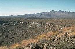
The volcanoes here have erupted here sporadically since about 4 million years ago, probably in association with the opening of the Gulf of California. The most recent volcanic activity was about 11,000 years ago. The Pinacate Desert is home to the largest sand dunes of the Americas.[2]
Flora and fauna
A variety of flora and fauna occur in the Pinacate Mountains, including the sculptural Elephant Tree, Bursera microphylla.[3]
Human history
Padre Eusebio Kino, founder of many Spanish missions in the Sonoran Desert, explored here in 1698 and several times later. NASA sent its astronauts here, from 1965 to 1970, to train for lunar excursions given the similarity of the terrain to the lunar surface.
El Pinacate y Gran Desierto de Altar Biosphere Reserve
The El Pinacate y Gran Desierto de Altar Biosphere Reserve is a biosphere reserve, in the spanish language Reserva de la Biosfera el Pinacate y Gran Desierto de Altar, managed by the Mexican Federal Government's SEMARNAT - the Ministry of the Environment and Natural Resources, in collaboration with the government of the State of Sonora's IMADES agency.[4]
The reserve
Facts about the reserve:[5]
- Over 600 square miles (1,600 km2)
- Over 400 cinder cones (caused by volcanic activity)
- 9 massive volcanic craters
- Remains of volcanic activity (ash, basalt rock, lava fields)
- Over 560 plant species
- 56 mammal species
- 43 reptile species
- 222 bird species
- 4 fish species.
See also
References
- ↑ U.S. National Aeronautics and Space Administration. NASA Information and Satellite Image: Pinacate Mountains
- ↑ http://www.biology.ed.ac.uk/research/groups/jdeacon/desertecology/pinacate.htm
- ↑ C. Michael Hogan. 2009. Elephant Tree: Bursera microphylla, GlobalTwitcher.com, ed. N. Stromberg
- ↑ http://www.cedointercultural.org/pinacate.htm . accessed 7/22/2010
- ↑ http://www.desertinvasion.us/areas/pinacate_res.html
External links
| Wikimedia Commons has media related to El Pinacate y Gran Desierto de Altar. |
- Official Pinacate y Gran Desierto de Altar Biosphere Reserve website
- Sierra Pinacate a Volcanic Wonder
- Global Volcanism Program: Pinacate Mountains
- Cerro Pinacate, at summitpost