Puerto Armuelles
| Puerto Armuelles Rabo De Puerco El Petrolero | |
|---|---|
| City and corregimiento | |
| Nickname(s): The petroleum capital of Panama | |
 Puerto Armuelles global positioning | |
| Country | Panama |
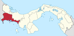
| Province | Chiriquí |
| District | Barú |
| Founded | 1928 |
| City Status | 1990 |
| Government | |
| • Type | Cosmopolitan borough, City |
| • Governing body | Puerto Armuelles City Council |
| Area[1] | |
| • Land | 222.5 km2 (85.9 sq mi) |
| Population (2010)[1] | |
| • Total | 20,455 |
| • Density | 91.9/km2 (238/sq mi) |
| Population density calculated based on land area. | |
| Climate | Am |
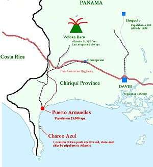
Puerto Armuelles is a city and corregimiento on Panama's Pacific coast in western Chiriquí Province next to Costa Rica. It is the seat of Barú District.[1] Puerto Armuelles is the second largest city in Chiriqui province with a population near 25,000, and has two different type of deep-water ports, one for bananas and one for oil.
Overview
Puerto Armuelles is a beach town right on the Pacific Ocean. Starting in 1927, the town was literally built by Chiquita Banana (formerly called the United Fruit Company). The name, Puerto Armuelles, was given to the city in honor of one of the heroes of the Coto war, Colonel Tomás Armuelles. Colonel Armuelles was a member of the Panamanian Defense Forces (PDF). On March 18, 1921, he died in a train accident during the Coto War between Panama and Costa Rica. Puerto Armuelles had formerly been called "Rabo de Puerco" or "Pigtail".
Puerto Armuelles is in the Chiriquí Province of Panama. The capital of the province, David, is 60 miles (97 km) away. It is only 5 miles (8.0 km) from the border with Costa Rica as the crow flies yet the actual border crossing lis 21 miles (34 km) away at the town of Paso Canoas. Panama City is some 235 miles (378 km) way, or approximately 6–8 hours drive on the Pan American Highway. Boquete, a popular destination for international expats, is 133 km away by road. Currently, the highway linking Puerto Armuelles to the Pan American Highway at Paso Canoas is doubling in size from 2 to 4 lanes. As of February 2016, the work on this road expansion is mostly complete, but is still not done, especially on the bridges.
Puerto Armuelles' most famous citizen is Omar Moreno, who was a baseball outfielder from 1975 to 1986 in the U.S.
Puerto Armuelles was once the center of a Chiquita Banana's thriving banana business. Then its workers started striking and other activities designed to harm Chiquita Banana i.e. United Fruit Company. Finally, in 2003, Chiquita sold its now unprofitable Puerto Armuelles business to a cooperative of local banana workers, called Coosemupar. After Chiquita left, Puerto Armuelles' population dropped significantly. In 1990, its population was 46,093. Then in 2000, only 22,755 people remained. In 2010 the population was at 20,455.[1] As of 2016, there are rumors that Del Monte may start producing bananas in the old Chiquita Banana plantation lands in Puerto Armuelles.
Panama fought Costa Rica in the 1920s near Puerto Armuelles in what is called the Coto War. This war was fought over a relatively small piece of territory. Panama was victorious. However, in 1940, Panama gave the territory back to Costa Rica. This happened after the dispute was mediated by the U.S.A. and found in favor of Costa Rica. The President of Panama decided to abide by that ruling although it was a very unpopular decision in Panama. An interesting side note is that today Panama and Costa Rica both have no military, just a civil defense force. Both countries, although doing so decades apart, felt that this was the only way to end military takeovers of their governments. For more info see military of Panama.
Heavy industry and petroleum
Puerto Armuelles does have some oil-related employment due to the size or lack of it, of the Panama Canal. The Panama Canal cannot handle supertankers and therefore not able to cross over to the Atlantic Ocean and then onward to the refineries of Houston and the Gulf coast. About 6 miles away from Puerto Armuelles, on Punta Burica, in the deep water of Charco Azul or in English "Blue Ditch" they found an ideal place to bring in those Super Tankers and unload. They would then put the oil into Panamax tankers so the oil could then cross the canal and on to the U.S. refineries. Very soon after that operation started, they realized it would be better to have a pipeline. They built the pipeline in 1982, at that same spot, which they dubbed the Petroterminales of Panama or PTP. The pipeline starts at the PTP and ends at the town of Chiriqui Grande, on the Caribbean coast in the Bocas del Toro province. The pipeline goes over the mountains between the PTP and Chiriqui Grande with the help of pumping stations like that at Boquete. From there they fill supertankers with the oil and they transport it to

U.S. refineries.
At one time there was a lot of talk of a refinery being built out by the PTP. In 2006 it was announced that Puerto Armuelles was in the running to be considered for a refinery. Occidental (OXY) said they were interested. At the time, it was estimated that the refinery, with a cost of about $7 billion dollars, will be able to process 400,000 barrels (64,000 m3) of heavy crude from Mexico, South America, and the Middle East. In 2009, due to the economic downturn globally the plans for a refinery were put on hold. Now, in 2016, it seems extremely unlikely that a refinery will ever be at the PTP. However, they did increase the number of oil holding tanks at the PTP. The oil holding tanks are so large that you can see them from the town of Puerto Armuelles.

Earthquakes

Earthquakes have hit Puerto Armuelles several time including one in July 1934 and another on Christmas night 2003 both of which killed several locals. On July 1, 1979 an earthquake hit Puerto Armuelles, which destroyed the poorly built multistory high school (fortunately it was a Sunday afternoon). The oil terminal also suffered extensive damage worth $2 million, including the loss of a very expensive part into the deep water of Charco Azul, and, although divers were contracted, the steep descent of the ocean floor led to the part rolling off and never being recovered.
Beyond the earthquakes which are common anywhere in the Pacific Rim of fire, Puerto Armuelles' weather is tropical weather for latitude 8.28333 degrees. Highs around 92 °F most days and lows around 72 °F at night. The beach is nearby if it is too hot for you or up the mountain to Volcan Baru, which towers over the area at 11,400 feet (3478 m) high, and can be seen from hills of Monte Verde. Puerto Armuelles currently is "a company town which lost its company" according to the weekly newsletter "So you want to retire to Panama" May 9, 2005 edition by Paradise Services. Also the mass migration of the young people to the big cities, particularly Panama City, has been on going for decades just like in the U.S. rural areas.
Future of Bananas In Puerto Armuelles
The worker's cooperative, Coosemupar, did not do well after Chiquita left. In 2003, Coosemupar, with government help, purchased Chitiquta Banana's Puerto Armuelles banana operations. Coosemupar did not do well. They were many reasons for this, but regardless of why, for many years they relied on the Panamanian government to continually bail them out. Coosemupar tried to sell its operations for years, but no new banana company has wanted to start a business saddled with Coosemupar's enormous debt. Finally, the government said enough and they refused to subsidize Coosemupar any longer.
However, the government, like Coosemupar wants to sell the banana plantations and operations to a banana company. Consequently, in January 2012, President Martinelli and members of Coosemupar, signed an agreement that states that the government will: 1) Pay off Coosemupar’s 19.7 million dollar debt. Which means the 24 banana plantations will then revert to Government ownership. 2) Give relief and land to the plantation workers who still live on the plantations. 3) Sell the 24 banana plantations (fincas) to company(s) that will provide the greatest number of jobs.
For awhile, the government was in negotiations with Chiquita to come back and produce bananas in Puerto Armuelles. But those negotiations fell through. Most recently, in 2016, the government is in talks with Del Monte.
Road Expansion & Port
During President Martinelli's term, money was allocated to widen the road to Puerto Armuelles from a 2-lane into a 4-lane road. This is the road that links PUerto Armuelles to the Pan-American Highway (called the InterAmericana in Panama) at Paso Canoas. Paso Canoas is the border town of Costa Rica and Panama, on the Pan-American Highway.
According to the Panama government, one of the key reasons for this road expansion project is to service a proposed deep container port outside of Puerto Armuelles. The proposal is for this multi-purpose port to include 217 storage facilities, a deepwater container, future cruise ship port, and a marina. The idea is that the expanded road and the proposed port would create what the Panama government is callings a 4 lane “dry canal” highway connecting Puerto Armulles to Chiriqui Grande on the Caribbean side of Panama. They are hopeful that it would have a similar economic effect as the “wet canal” in Panama City.
As of February 2016, the road expansion is about 75% complete. There are parts of the road, notably through the town of Progresso as well as most of the bridges that still need to be expanded.
How To Get To Puerto Armuelles
Directions to Puerto Armuelles - starting from Paso Canoas, Panama.
Paso Canoas, Panama is on the border between Panama and Costa Rica. It is right on the Pan-American or InterAmericana highway.
At Paso Canoas, turn south, towards the Pacific Ocean.
The road will meander, mostly in a southern direction, for about 21 miles (34 km) where it ends in Puerto Armuelles.
If you are in Panama, the turn you take in Paso Canoas is immediately in front of the border crossing. Do not cross the border into Costa Rica. Google Maps will tell you to do this – Don’t.
Directions to Puerto Armuelles's downtown waterfront park - starting from the outskirts of town
1) Veer right at the first fork in the road. This fork is located a 1/2 mile (.8 km) after you cross the main bridge coming into town. Formerly, there was both a gas station and a bus stop at this fork. As of February 2016, the gas station has been removed. It is a big construction site where they are building a bigger and better gas station. The bus stop remains. It is seemingly in the middle of the road.
Straight ahead at this fork, you may see Puerto Armuelles biggest baseball stadium, which has tall outside lights. Don't go toward it. That will lead you into the neighborhood of Rio Mar. You can make your way to downtown Puerto Armuelles that way, but you can also easily get lost.
It is best to veer right at that fork. You will pass Enrique Restaurante and then a fire station, both on your right.
2) Turn left in 2/3rds of a mile (1.1 km). The road comes to somewhat of a T intersection just past a high school, ESPA, which is on your right. You will see a big cement Coke bottle to your left. The road to your right has a stop sign, which is not always obeyed. So be careful.
Keep following that road. Very soon you will cross a bridge. Right after the bridge, there will be a Romero Supermercado on your right. You are now entering the outskirts of downtown Puerto Armuelles.
In two tenths of a mile (.33 km) after the bridge by Romeros, you will pass the road to the local hospital on your left. Then road will curve right and you will arrive at an intersection with a statue with a dolphin.
3) Arrive at an intersection, in the middle of which is a statue with dolphin. This sometimes busy intersection can be confusing.
Go around the dolphin statue in the middle of the road. This means you will,
4) Turn right, and then take an immediate left - going around the statue
5) Take the next right. This is in about 300 yards. You cannot go straight because the road turns into a one-way road, going the other way.
7) At the stop sign turn left. It is in about 600 yards. In front of you is a playground. You will turn onto a road with a planted median.
8) Take the next right - at the corner of gazebo park. It is in about 100 yards.
9) At stop sign, take a left. In front of you is the waterfront park in downtown Puerto Armuelles.
You have arrived.
To the right, is the pier. [2]
Personalities
- Omar Moreno, baseball player and member of the 1979 Pittsburgh Pirates, World Champions
References
- 1 2 3 4 "Cuadro 11 (Superficie, población y densidad de población en la República...)" [Table 11 (Area, population, and population density in the Republic...)] (.xls). In "Resultados Finales Básicos" [Basic Final Results] (in Spanish). National Institute of Statistics and Census of Panama. Retrieved May 26, 2015.
- ↑ http://www.livinginpanama.com/puerto-armuelles-panama/directions/
Coordinates: 8°17′N 82°52′W / 8.283°N 82.867°W