Bugaba District
| Bugaba District | |
|---|---|
| District | |
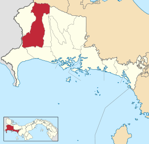 | |
 Bugaba District Location of the district capital in Panama | |
| Coordinates: 8°28′48″N 82°37′12″W / 8.48000°N 82.62000°WCoordinates: 8°28′48″N 82°37′12″W / 8.48000°N 82.62000°W | |
| Country |
|
| Province | Chiriquí Province |
| Capital | La Concepción |
| Area | |
| • Total | 341 sq mi (884 km2) |
| Population (2000) | |
| • Total | 68,570 |
| Time zone | ETZ (UTC-5) |
Bugaba District (Spanish pronunciation: [ˈbuɣaβa]) is a district (distrito) of Chiriquí Province in Panama. The population according to the 2000 census was 68,570.[1] The district covers a total area of 884 km². The capital lies at the city of La Concepción.[1]
Administrative divisions
The district is divided administratively into the following corregimientos:
La Concepción (capital), Aserrío de Gariché, Bugaba, Gómez, La Estrella, San Andrés, Santa Marta, Santa Rosa, Santo Domingo, Sortová, and El Bongo.
References
- 1 2 "Districts of Panama". Statoids. Retrieved April 10, 2009.
| Bocas del Toro Province | |
|---|---|
| Chiriquí Province | |
| Coclé Province | |
| Colón Province | |
| Darién Province | |
| Herrera Province | |
| Los Santos Province | |
| Panamá Province | |
| Veraguas Province | |
| West Panamá Province | |
This article is issued from Wikipedia - version of the 10/4/2015. The text is available under the Creative Commons Attribution/Share Alike but additional terms may apply for the media files.