Prežba
 | |
| Geography | |
|---|---|
| Location | Adriatic Sea |
| Coordinates | 42°46′20″N 16°48′34″E / 42.77222°N 16.80944°ECoordinates: 42°46′20″N 16°48′34″E / 42.77222°N 16.80944°E |
| Archipelago | Lastovo |
| Area | 2.81 km2 (1.08 sq mi) |
| Administration | |
| County | Dubrovnik-Neretva |
_na_Lastovu.JPG)
Prežba
.JPG)
Navy military object on Prežba
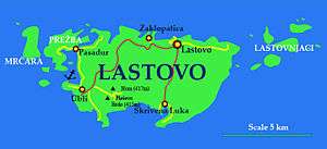
Prežba is a small uninhabited island in the Croatian part of the Adriatic Sea, located northwest of the island of Lastovo in southern Dalmatia. It is connected to Lastovo by a bridge at the village of Pasadur on Lastovo. Prežba's area is 2.81 km²,[1] but its coastline is 14.23 km long, due to the large number of coves on the island.Its highest peak is 136 m above sea level and there is a lighthouse on the south side of the island, across the bay from Ubli. The island was used my the Yugoslav People's Army as a military base containing a tunnel and tunnel for ships
See also
References
- ↑ Duplančić Leder, Tea; Ujević, Tin; Čala, Mendi (June 2004). "Coastline lengths and areas of islands in the Croatian part of the Adriatic Sea determined from the topographic maps at the scale of 1 : 25 000" (PDF). Geoadria. Zadar. 9 (1): 5–32. Retrieved 2011-01-21.
This article is issued from Wikipedia - version of the 11/17/2016. The text is available under the Creative Commons Attribution/Share Alike but additional terms may apply for the media files.