Potsdam (village), New York
| Potsdam | |
|---|---|
| Village | |
|
Market Street in Potsdam | |
| Motto: Si vis pacem para bellum | |
 Potsdam, New York from OpenStreetMap | |
 Potsdam Location within the state of New York | |
| Coordinates: 44°40′15″N 74°59′3″W / 44.67083°N 74.98417°WCoordinates: 44°40′15″N 74°59′3″W / 44.67083°N 74.98417°W | |
| Country | United States |
| State | New York |
| County | St. Lawrence |
| Area | |
| • Total | 4.8 sq mi (12.6 km2) |
| • Land | 4.4 sq mi (11.4 km2) |
| • Water | 0.5 sq mi (1.2 km2) |
| Elevation | 433 ft (132 m) |
| Population (2010) | |
| • Total | 9,428 |
| • Density | 2,148.2/sq mi (829.4/km2) |
| Time zone | Eastern (EST) (UTC-5) |
| • Summer (DST) | EDT (UTC-4) |
| FIPS code | 36-59564 |
| GNIS feature ID | 0977239 |

Potsdam is a village located in the Town of Potsdam in St. Lawrence County, New York, United States. The population was 9,428 at the 2010 census. The Village of Potsdam is in the eastern part of the town and is northeast of Canton, the county seat. The village is the locale of the State University of New York at Potsdam and Clarkson University.
History
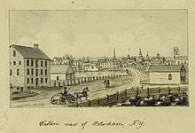
The village was formerly a community of the St. Regis Indians. The early European settlers arrived at that location circa 1803.
The village was incorporated in 1831. In 1841, the village charter was amended to increase the size of the village.
Potsdam was the seventh town erected by an Act of the Legislature passed February 21, 1806, formerly attached to Madrid. It was one of the original ten townships, No. 3, and is said to have been named thus by the commissioners on the discovery by the surveyors of a bed of reddish sandstone resembling the sandstone in the Potsdam, Germany.[1]
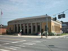
The Market Street Historic District, Bayside Cemetery and Gatehouse Complex, Clarkson Office Building, Clarkson-Knowles Cottage, Nathaniel Parmeter House, Trinity Episcopal Church, and United States Post Office are listed on the National Register of Historic Places.[2]
Geography
Potsdam is located at 44°40′15″N 74°59′3″W / 44.67083°N 74.98417°W (44.670873, -74.984281).[3]
According to the United States Census Bureau, the village has a total area of 4.8 square miles (12.6 km²), of which 4.4 square miles (11.4 km²) is land and 0.5 square mile (1.2 km²) (9.48%) is water.
The village is on the banks of the Raquette River.
U.S. Route 11 passes through the village from east to west, and New York State Route 56 passes through from north to south. New York State Route 11B enters from the east, and New York State Route 345 enters from the northwest.
Demographics
| Historical population | |||
|---|---|---|---|
| Census | Pop. | %± | |
| 1850 | 1,471 | — | |
| 1860 | 1,699 | 15.5% | |
| 1870 | 2,891 | 70.2% | |
| 1880 | 2,762 | −4.5% | |
| 1890 | 3,961 | 43.4% | |
| 1900 | 3,843 | −3.0% | |
| 1910 | 4,036 | 5.0% | |
| 1920 | 4,039 | 0.1% | |
| 1930 | 4,136 | 2.4% | |
| 1940 | 4,821 | 16.6% | |
| 1950 | 7,491 | 55.4% | |
| 1960 | 7,765 | 3.7% | |
| 1970 | 10,303 | 32.7% | |
| 1980 | 10,635 | 3.2% | |
| 1990 | 10,251 | −3.6% | |
| 2000 | 9,425 | −8.1% | |
| 2010 | 9,428 | 0.0% | |
| Est. 2015 | 9,688 | [4] | 2.8% |
As of the census[6] of 2010, there were 9,428 people, 2,265 households, and 1,040 families residing in the village. The population density was 2,148.2 people per square mile (828.9/km²). There were 2,705 housing units at an average density of 616.5 per square mile (237.9/km²). The racial makeup of the village was 91.60% White, 2.50% Black or African American, 0.36% Native American, 3.88% Asian, 0.01% Pacific Islander, 0.53% from other races, and 1.11% from two or more races. Hispanic or Latino of any race were 1.75% of the population.
There were 2,543 households out of which 21.5% had children under the age of 18 living with them, 28.5% were married couples living together, 10.3% had a female householder with no husband present, and 59.1% were non-families. 40.8% of all households were made up of individuals and 15.6% had someone living alone who was 65 years of age or older. The average household size was 2.14 and the average family size was 2.90.
In the village the population was spread out with 11.3% under the age of 18, 56.2% from 18 to 24, 14.1% from 25 to 44, 9.4% from 45 to 64, and 9.1% who were 65 years of age or older.
The median age was 22 years. For every 100 females there were 110.1 males. For every 100 females age 18 and over, there were 109.8 males.
The median income for a household in the village was $21,273, and the median income for a family was $37,933. Males had a median income of $31,610 versus $24,324 for females. The per capita income for the village was $10,824. About 18.2% of families and 34.0% of the population were below the poverty line, including 20.8% of those under age 18 and 13.8% of those age 65 or over.
Gallery
 First Presbyterian Church of Potsdam
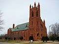 St. Mary's Catholic Church
 SUNY Potsdam's Satterlee Hall
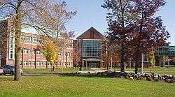 Clarkson U., Bertrand H. Snell Hall
Radio
References
- ↑ "In depth history here". History.rays-place.com. 2007-05-17. Retrieved 2012-09-24.
- ↑ National Park Service (2009-03-13). "National Register Information System". National Register of Historic Places. National Park Service.
- ↑ "US Gazetteer files: 2010, 2000, and 1990". United States Census Bureau. 2011-02-12. Retrieved 2011-04-23.
- ↑ "Annual Estimates of the Resident Population for Incorporated Places: April 1, 2010 to July 1, 2015". Retrieved July 2, 2016.
- ↑ "Census of Population and Housing". Census.gov. Retrieved June 4, 2015.
- ↑ "American FactFinder". United States Census Bureau. Retrieved 2008-01-31.
- ↑ "1340wmsa.com". 1340wmsa.com. Retrieved 2012-09-24.
- ↑ "radio.clarkson.edu". radio.clarkson.edu. Retrieved 2012-09-24.
- ↑ "mymix961.com". mymix961.com. Retrieved 2012-09-24.
- ↑ "1015thefox.com". 1015thefox.com. Retrieved 2012-09-24.
External links
| Wikivoyage has a travel guide for Potsdam (New York). |
Municipalities and communities of St. Lawrence County, New York, United States | ||
|---|---|---|
| City |  | |
| Towns | ||
| Villages | ||
| CDPs |
| |
| Hamlets | ||