Port Alexander, Alaska
| Port Alexander, Alaska | |
|---|---|
| City | |
 Port Alexander, Alaska Location in the United States | |
| Coordinates: 56°14′24″N 134°39′26″W / 56.24000°N 134.65722°WCoordinates: 56°14′24″N 134°39′26″W / 56.24000°N 134.65722°W | |
| Country | United States |
| State | Alaska |
| Census Area | Prince of Wales-Hyder |
| Incorporated | July 9, 1974[1] |
| Government | |
| • Mayor | Ryan Martin |
| • State senator | Bert Stedman (R) |
| • State rep. | Jonathan Kreiss-Tomkins (D) |
| Area | |
| • Total | 15.0 sq mi (39.0 km2) |
| • Land | 3.8 sq mi (9.8 km2) |
| • Water | 11.3 sq mi (29.2 km2) |
| Elevation | 43 ft (13 m) |
| Population (2010) | |
| • Total | 52 |
| • Density | 13.6/sq mi (5.3/km2) |
| Time zone | Alaska (AKST) (UTC-9) |
| • Summer (DST) | AKDT (UTC-8) |
| ZIP code | 99836 |
| Area code | 907 |
| FIPS code | 02-62510 |
| GNIS feature ID | 1424551 |
Port Alexander is a city at the southeastern corner of Baranof Island in Prince of Wales-Hyder Census Area,[2] Alaska, United States. At the 2000 census the population was 81.
History
Port Alexander once was a bustling city with as many as 2,500 people in the early 20th century,[3] Prior to the 1920s, Port Alexander was the salmon fishing capital of the world.
Port Alexander originally incorporated in 1936. It became a part of the Greater Sitka Borough in 1963, following the state legislature's passage of the Mandatory Borough Act. The original municipality was dissolved when it unified with Sitka's city and borough governments in 1971, which formed the present-day entity known as the City and Borough of Sitka. However, residents were unhappy with the arrangement, and successfully sought to detach themselves from the new municipality. Port Alexander reincorporated as a second class city in 1974.
Currently, the Port Alexander Historical Society is undertaking the project of creating a small museum celebrating the town's history.
Geography
Port Alexander is located at 56°14′24″N 134°39′26″W / 56.24000°N 134.65722°W (56.239871, -134.657177).[4]
Port Alexander is the only city on a small sliver of land at the southeastern corner of Baranof Island that is not part of the City and Borough of Sitka. It comprises less than one-quarter of one percent of Baranof Island's land area.
According to the United States Census Bureau, the city has a total area of 15.1 square miles (39 km2), of which, 3.8 square miles (9.8 km2) of it is land and 11.3 square miles (29 km2) of it (74.88%) is water.
Climate
Despite its latitude at 56°14'N Port Alexander has a oceanic climate (Köppen climate classification: Cfb ) with cool, wet(In Port Alexander's case snowy) winters, and mild, dry summers.
| Climate data for Port Alexander, Alaska | |||||||||||||
|---|---|---|---|---|---|---|---|---|---|---|---|---|---|
| Month | Jan | Feb | Mar | Apr | May | Jun | Jul | Aug | Sep | Oct | Nov | Dec | Year |
| Record high °F (°C) | 61 (16) |
63 (17) |
62 (17) |
82 (28) |
88 (31) |
89 (32) |
89 (32) |
90 (32) |
82 (28) |
71 (22) |
67 (19) |
62 (17) |
90 (32) |
| Average high °F (°C) | 38 (3) |
41 (5) |
44 (7) |
49 (9) |
56 (13) |
61 (16) |
64 (18) |
64 (18) |
60 (16) |
52 (11) |
44 (7) |
40 (4) |
51.1 (10.6) |
| Daily mean °F (°C) | 34 (1) |
37 (3) |
39 (4) |
43 (6) |
49 (9) |
54 (12) |
58 (14) |
59 (15) |
54 (12) |
47 (8) |
40 (4) |
36 (2) |
45.8 (7.5) |
| Average low °F (°C) | 29 (−2) |
32 (0) |
33 (1) |
37 (3) |
42 (6) |
48 (9) |
52 (11) |
52 (11) |
48 (9) |
42 (6) |
35 (2) |
31 (−1) |
40.1 (4.6) |
| Record low °F (°C) | 1 (−17) |
2 (−17) |
1 (−17) |
21 (−6) |
31 (−1) |
37 (3) |
40 (4) |
40 (4) |
33 (1) |
18 (−8) |
−3 (−19) |
1 (−17) |
−3 (−19) |
| Average precipitation inches (mm) | 10.10 (256.5) |
9.00 (228.6) |
8.70 (221) |
8.50 (215.9) |
6.50 (165.1) |
5.00 (127) |
4.70 (119.4) |
6.90 (175.3) |
9.90 (251.5) |
16.50 (419.1) |
12.90 (327.7) |
12.10 (307.3) |
110.8 (2,814.4) |
| Average snowfall inches (cm) | 13.00 (33.02) |
10.01 (25.43) |
8.98 (22.81) |
2.01 (5.11) |
0 (0) |
0 (0) |
0 (0) |
0 (0) |
0 (0) |
0 (0) |
2.99 (7.59) |
10.99 (27.91) |
47.98 (121.87) |
| Source: http://www.myforecast.com/bin/climate.m?city=10706&metric=false | |||||||||||||
Demographics
| Historical population | |||
|---|---|---|---|
| Census | Pop. | %± | |
| 1930 | 107 | — | |
| 1940 | 87 | −18.7% | |
| 1950 | 22 | −74.7% | |
| 1960 | 18 | −18.2% | |
| 1970 | 36 | 100.0% | |
| 1980 | 86 | 138.9% | |
| 1990 | 119 | 38.4% | |
| 2000 | 81 | −31.9% | |
| 2010 | 52 | −35.8% | |
| Est. 2015 | 54 | [5] | 3.8% |
As of the census[7] of 2000, there were 81 people, 34 households, and 19 families residing in the city. The population density was 21.5 people per square mile (8.3/km²). There were 79 housing units at an average density of 20.9 per square mile (8.1/km²). The racial makeup of the city was 83.95% White, 4.94% Native American, and 11.11% from two or more races. 4.94% of the population were Hispanic or Latino of any race.
There were 34 households out of which 29.4% had children under the age of 18 living with them, 58.8% were married couples living together, and 41.2% were non-families. 38.2% of all households were made up of individuals and 5.9% had someone living alone who was 65 years of age or older. The average household size was 2.38 and the average family size was 3.30.
In the city the age distribution of the population shows 30.9% under the age of 18, 3.7% from 18 to 24, 29.6% from 25 to 44, 33.3% from 45 to 64, and 2.5% who were 65 years of age or older. The median age was 38 years. For every 100 females there were 113.2 males. For every 100 females age 18 and over, there were 115.4 males.
The median income for a household in the city was $31,563, and the median income for a family was $31,875. Males had a median income of $51,250 versus $41,250 for females. The per capita income for the city was $14,767. There were 25.0% of families and 22.9% of the population living below the poverty line, including 18.5% of under eighteens and none of those over 64.
References
- ↑ 1996 Alaska Municipal Officials Directory. Juneau: Alaska Municipal League/Alaska Department of Community and Regional Affairs. January 1996. p. 122. The incorporation followed the detachment of the area from the original boundaries of the City and Borough of Sitka.
- ↑ http://labor.alaska.gov/research/census/maps/bor/02198.pdf
- ↑ Kirchhoff, M. J. "Baranof Island, An Illustrated History." Alaska Cedar Press, 1990, p. 76.
- ↑ "US Gazetteer files: 2010, 2000, and 1990". United States Census Bureau. 2011-02-12. Retrieved 2011-04-23.
- ↑ "Annual Estimates of the Resident Population for Incorporated Places: April 1, 2010 to July 1, 2015". Retrieved July 2, 2016.
- ↑ "Census of Population and Housing". Census.gov. Retrieved June 4, 2015.
- ↑ "American FactFinder". United States Census Bureau. Retrieved 2008-01-31.
Municipalities and communities of Prince of Wales–Hyder Census Area, Alaska, United States | ||
|---|---|---|
| Cities | 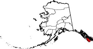 | |
| CDPs | ||
| Unincorporated community | ||