Pleasant Township, Grant County, Indiana
| Pleasant Township | |
|---|---|
| Township | |
|
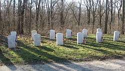
Cemetery at the Mississinewa Battlefield | |
 Location of Pleasant Township in Grant County | |
| Coordinates: 40°36′42″N 85°44′00″W / 40.61167°N 85.73333°WCoordinates: 40°36′42″N 85°44′00″W / 40.61167°N 85.73333°W | |
| Country | United States |
| State | Indiana |
| County | Grant |
| Government | |
| • Type | Indiana township |
| Area | |
| • Total | 35.11 sq mi (90.9 km2) |
| • Land | 34.83 sq mi (90.2 km2) |
| • Water | 0.28 sq mi (0.7 km2) 0.80% |
| Elevation | 827 ft (252 m) |
| Population (2010) | |
| • Total | 6,797 |
| • Density | 195.1/sq mi (75.3/km2) |
| GNIS feature ID | 0453745 |
Pleasant Township is one of thirteen townships in Grant County, Indiana, United States. As of the 2010 census, its population was 6,797 and it contained 3,166 housing units.[1]
History
The Meshingomesia Cemetery and Indian School Historic District was listed on the National Register of Historic Places in 2013.[2]
Geography
According to the 2010 census, the township has a total area of 35.11 square miles (90.9 km2), of which 34.83 square miles (90.2 km2) (or 99.20%) is land and 0.28 square miles (0.73 km2) (or 0.80%) is water.[1] The stream of Jocinah Creek runs through this township.
Cities and towns
Unincorporated towns
(This list is based on USGS data and may include former settlements.)
Adjacent townships
- Liberty Township, Wabash County (north)
- Washington Township (east)
- Center Township (southeast)
- Franklin Township (south)
- Sims Township (southwest)
- Richland Township (west)
- Waltz Township, Wabash County (northwest)
Cemeteries
The township contains two cemeteries: Maple Grove and Meshingomesia.
Major highways
References
- 1 2 "Population, Housing Units, Area, and Density: 2010 - County -- County Subdivision and Place -- 2010 Census Summary File 1". United States Census. Retrieved 2013-05-10.
- ↑ "National Register of Historic Places Listings". Weekly List of Actions Taken on Properties: 1/07/13 through 1/11/13. National Park Service. 2013-01-18.
External links
Municipalities and communities of Grant County, Indiana, United States | ||
|---|---|---|
| Cities | ||
| Towns | ||
| Townships | ||
| CDPs | ||
| Unincorporated communities | ||
| Footnotes | ‡This populated place also has portions in an adjacent county or counties | |
This article is issued from Wikipedia - version of the 9/4/2016. The text is available under the Creative Commons Attribution/Share Alike but additional terms may apply for the media files.