Perryman, Maryland
| Perryman, Maryland | |
|---|---|
| CDP | |
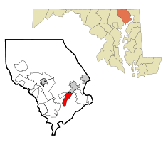 Location of Perryman, Maryland | |
| Coordinates: 39°28′7″N 76°12′47″W / 39.46861°N 76.21306°WCoordinates: 39°28′7″N 76°12′47″W / 39.46861°N 76.21306°W | |
| Country | United States |
| State | Maryland |
| County | Harford |
| Area | |
| • Total | 5.5 sq mi (14.3 km2) |
| • Land | 5.5 sq mi (14.2 km2) |
| • Water | 0.0 sq mi (0.1 km2) |
| Elevation | 39 ft (12 m) |
| Population (2000) | |
| • Total | 2,461 |
| • Density | 450.2/sq mi (173.8/km2) |
| Time zone | Eastern (EST) (UTC-5) |
| • Summer (DST) | EDT (UTC-4) |
| ZIP code | 21130 |
| Area code(s) | 410 |
| FIPS code | 24-61075 |
| GNIS feature ID | 0590998 |
Perryman is a census-designated place (CDP) in Harford County, Maryland, United States. The population was 2,461 at the 2000 census.
History
St. George's Parish Vestry House was listed on the National Register of Historic Places in 1976.[1]
Geography
Perryman is located at 39°28′7″N 76°12′47″W / 39.46861°N 76.21306°W (39.468509, -76.213090).[2]
According to the United States Census Bureau, the CDP has a total area of 5.5 square miles (14 km2), of which, 5.5 square miles (14 km2) of it is land and 0.04 square miles (0.10 km2) of it (0.73%) is water.
Climate
The climate in this area is characterized by hot, humid summers and generally mild to cool winters. According to the Köppen Climate Classification system, Perryman has a humid subtropical climate, abbreviated "Cfa" on climate maps.[3]
Demographics
As of the census[4] of 2000, there were 2,461 people, 960 households, and 696 families residing in the CDP. The population density was 450.2 people per square mile (173.7/km²). There were 1,024 housing units at an average density of 187.3/sq mi (72.3/km²). The racial makeup of the CDP was 71.76% White, 24.42% African American, 0.24% Native American, 0.81% Asian, 0.69% from other races, and 2.07% from two or more races. Hispanic or Latino of any race were 2.64% of the population.
There were 960 households out of which 37.5% had children under the age of 18 living with them, 47.0% were married couples living together, 21.5% had a female householder with no husband present, and 27.5% were non-families. 21.9% of all households were made up of individuals and 6.1% had someone living alone who was 65 years of age or older. The average household size was 2.55 and the average family size was 2.94.
In the CDP the population was spread out with 28.7% under the age of 18, 7.5% from 18 to 24, 29.7% from 25 to 44, 23.0% from 45 to 64, and 11.1% who were 65 years of age or older. The median age was 36 years. For every 100 females there were 88.4 males. For every 100 females age 18 and over, there were 83.3 males.
The median income for a household in the CDP was $33,972, and the median income for a family was $40,938. Males had a median income of $35,979 versus $24,944 for females. The per capita income for the CDP was $17,236. About 17.5% of families and 17.4% of the population were below the poverty line, including 29.4% of those under age 18 and 2.9% of those age 65 or over.
References
- ↑ National Park Service (2008-04-15). "National Register Information System". National Register of Historic Places. National Park Service.
- ↑ "US Gazetteer files: 2010, 2000, and 1990". United States Census Bureau. 2011-02-12. Retrieved 2011-04-23.
- ↑ Climate Summary for Perryman, Maryland
- ↑ "American FactFinder". United States Census Bureau. Retrieved 2008-01-31.
Municipalities and communities of Harford County, Maryland, United States | ||
|---|---|---|
| Cities | 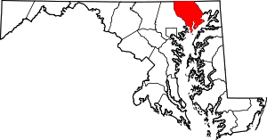 | |
| Town | ||
| CDPs | ||
| Other communities | ||