Fallston, Maryland
| Fallston, Maryland | |
|---|---|
| CDP" | |
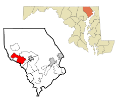 Location of Fallston, Maryland | |
| Coordinates: 39°31′55″N 76°26′17″W / 39.53194°N 76.43806°WCoordinates: 39°31′55″N 76°26′17″W / 39.53194°N 76.43806°W | |
| Country | United States |
| State | Maryland |
| County | Harford |
| Area | |
| • Total | 14.0 sq mi (36.3 km2) |
| • Land | 14.0 sq mi (36.3 km2) |
| • Water | 0.0 sq mi (0.0 km2) |
| Elevation | 466 ft (142 m) |
| Population (2000) | |
| • Total | 8,427 |
| • Density | 600.9/sq mi (232.0/km2) |
| Time zone | Eastern (EST) (UTC-5) |
| • Summer (DST) | EDT (UTC-4) |
| ZIP code | 21047 |
| Area code(s) | 410, 443 |
| FIPS code | 24-27700 |
| GNIS feature ID | 0584343 |
Fallston is a census-designated place (CDP) in Harford County, Maryland, United States. The population was 8,427 at the 2000 census. It is a semi-rural community consisting mostly of farms and suburban-like developments.
Geography
Fallston is located at 39°31′55″N 76°26′17″W / 39.53194°N 76.43806°W (39.532006, -76.438021).[1]
According to the United States Census Bureau, the CDP has a total area of 14.0 square miles (36 km2), all of it land.
Bon Air, Little Falls Meetinghouse and Rockdale are listed on the National Register of Historic Places.[2]
Demographics
As of the census[3] of 2000, there were 8,427 people, 2,875 households, and 2,550 families residing in the CDP. The population density was 600.9 people per square mile (232.1/km²). There were 2,906 housing units at an average density of 207.2/sq mi (80.0/km²). The racial makeup of the CDP was 97.33% White, 0.76% African American, 0.12% Native American, 1.10% Asian, 0.09% from other races, and 0.59% from two or more races including Hispanic or Latino.
There were 2,875 households out of which 37.3% had children under the age of 18 living with them, 81.5% were married couples living together, 5.3% had a female householder with no husband present, and 11.3% were non-families. 9.6% of all households were made up of individuals and 3.5% had someone living alone who was 65 years of age or older. The average household size was 2.93 and the average family size was 3.13.
In the CDP the population was spread out with 25.8% under the age of 18, 5.5% from 18 to 24, 23.0% from 25 to 44, 34.8% from 45 to 64, and 10.9% who were 65 years of age or older. The median age was 43 years. For every 100 females there were 98.6 males. For every 100 females age 18 and over, there were 95.2 males.
The median income for a household in the CDP was $84,296, and the median income for a family was $87,686. Males had a median income of $62,112 versus $37,500 for females. The per capita income for the CDP was $31,093. About 2.2% of families and 2.3% of the population were below the poverty line, including 3.4% of those under age 18 and 2.4% of those age 65 or over.
Gas station controversy
During the mid-2000s, Fallston was the location of an Exxon-Mobil station that was forced to close as a result of a heavily reported MTBE leak, and was one of several filling stations in the county being suspected of such leaks. The spills resulted in the county placing a six-month moratorium on construction of gas stations, and ultimately led the state to banning MTBE.
Notable residents
- Jim Hunter, Orioles broadcaster.
- Fred Manfra, Orioles broadcaster.
- Melvin Mora, Retired Professional Baseball Player.
- Bill Ripken, Former Orioles player.
- Gerry Sandusky, 11 News sportscaster WBAL-TV and Ravens radio broadcaster.
References
- ↑ "US Gazetteer files: 2010, 2000, and 1990". United States Census Bureau. 2011-02-12. Retrieved 2011-04-23.
- ↑ National Park Service (2010-07-09). "National Register Information System". National Register of Historic Places. National Park Service.
- ↑ "American FactFinder". United States Census Bureau. Retrieved 2008-01-31.
Municipalities and communities of Harford County, Maryland, United States | ||
|---|---|---|
| Cities | 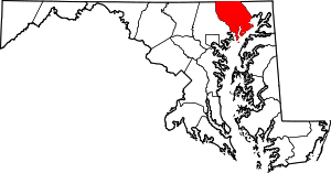 | |
| Town | ||
| CDPs | ||
| Other communities | ||