Perry South (Pittsburgh)
| Perry South Perry Hilltop | |
|---|---|
| Neighborhood of Pittsburgh | |
|
Along Perrysville Avenue in Perry South | |
 | |
| Coordinates: 40°28′05″N 80°00′54″W / 40.468°N 80.015°W | |
| Country | United States |
| State | Pennsylvania |
| County | Allegheny County |
| City | Pittsburgh |
| Area[1] | |
| • Total | 0.905 sq mi (2.34 km2) |
| Population (2010)[1] | |
| • Total | 4,145 |
| • Density | 4,600/sq mi (1,800/km2) |

Perry South (also known as Perry Hilltop) [2] is a neighborhood on Pittsburgh, Pennsylvania's North Side.
The neighborhood takes its name from Perrysville Avenue, which "was a part of the Venango trail, an Indian path leading north of 'Allegheny Town'. Commodore Perry used the Trail to carry supplies from Pittsburgh to Erie for his lake battle against the British during the War of 1812."[3] Perrysville Avenue is an extension of Federal Street, the main north-south thoroughfare of old Allegheny City. Federal Street ends, and Perrysville Avenue begins, where the flat river plain gives way to a steep hill. Perry South is thus a hilltop neighborhood that runs along Perrysville Avenue from the river plain (on the south) to Riverview Park (on the north).[4] The hill on which the neighborhood is built provides natural borders to the west (the Charles Street valley), to the east (the East Street valley), and to the south (Pleasant Valley).
The neighborhood was developed as a streetcar suburb, so it consists almost exclusively of residential housing, with a small business district at the intersection of Perrysville Avenue and Charles Avenue. It experienced white flight after 1960: from 1960 to 1970, the neighborhood's total population declined from 16,000 people to 13,000, while its African-American population, which had formerly been located almost exclusively in the Charles Street valley, increased from 15% to 20%.[5] From 1970 to 2000, the total population decreased to just 5,200 people, of whom 65% were African-American.[6] Current residents have formed the Perry Hilltop Citizens Council in an effort to prevent decay and to improve the neighborhood's business district.[7]
The southwestern corner of the neighborhood was once called Pleasant Valley, a small area that was nevertheless once considered to be a neighborhood in its own right.[8] A 1977 report about Pleasant Valley states that "Pleasant Valley was formerly known as Snyder's Hollow and its stream was a favorite ice skating spot. Primarily, the neighborhood was settled by Germans, Irish, Italians and Poles. Josh Gibson, Hall of Fame catcher for the Homestead Grays, a Negro National League team of the 1920s, lived there." Pleasant Valley consists of rowhouses which were built by the owners of the Pleasant Valley Street Railway - which operated the streetcars that first allowed Perry Hilltop to be developed. A series of these rowhouses, on Brightridge Street, have been listed with the National Register of Historic Places.[9]
Surrounding Pittsburgh neighborhoods
California-Kirkbride, Central North Side, Fineview, Brightwood, Northview Heights, Observatory Hill, Spring Hill
See also
Gallery
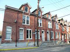 Houses at 838-862 Brightridge Street, built in 1887.
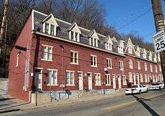 Houses at 2501-2531 Charles Street, built in 1885.
References
- 1 2 "PGHSNAP 2010 Raw Census Data by Neighborhood". Pittsburgh Department of City Planning. 2012. Retrieved 28 June 2013.
- ↑ "Perry Hilltop (formerly Perry South)". Pittsburgh Council District 1. City of Pittsburgh. Archived from the original on October 31, 2011.
- ↑ "North Side: Perry Hilltop". Bridging the Urban Landscape. Carnegie Library of Pittsburgh. Archived from the original on April 3, 2012.
- ↑ "Perry South". City of Pittsburgh Maps. City of Pittsburgh. Archived from the original on November 18, 2011.
- ↑ "Perry South" (PDF). Neighborhood Profiles. City of Pittsburgh Planning Department. Archived from the original (PDF) on April 15, 2012.
- ↑ "Perry South" (PDF). Census 2000 Demographic Profiles - City of Pittsburgh Neighborhoods. University (of Pittsburgh) Center for Social and Urban Research. Archived from the original (PDF) on April 15, 2012.
- ↑ Nelson Jones, Diana (April 12, 2010). "Group wants to spruce up Perry Hilltop". Pittsburgh Post-Gazette. Retrieved 2 November 2011.
- ↑ "Pleasant Valley" (PDF). An Atlas of the North Side. Archived from the original (PDF) on April 15, 2012.
- ↑ "Brightridge Street Rowhouse Historic District". Living Places. Gombach Group. Retrieved 2 November 2011.
External links
| Wikimedia Commons has media related to Perry South (Pittsburgh). |