Homewood (Pittsburgh)


Homewood is a predominantly African American neighborhood of Pittsburgh, Pennsylvania, United States, officially divided into three neighborhoods: Homewood North, Homewood South and Homewood West.
Homewood is bordered on the southwest by the Martin Luther King Jr. East Busway which follows the old Pennsylvania Railroad line toward downtown Pittsburgh.
Geography
Homewood is located in the easternmost part of Pittsburgh, bordered on the east by East Hills, on the west by Larimer and Shadyside, on the North by Lincoln-Lemington Belmar, and on the south by Point Breeze.[2]
History
Homewood was founded in 1832 by Judge William Wilkins (U.S. politician).[3] It was later annexed by the city of Pittsburgh on December 1, 1884.[3] Homewood in the beginning held mainly estates for the wealthy; Homewood was also the Pittsburgh residence of industrialists Andrew Carnegie and Thomas M. Carnegie until the late 1880s. Starting in the 1910s, Irish, Italian, German, and upper middle class black families started moving into Homewood due to the low-cost of housing. This caused Homewood to become more diverse. At first relations between the white and black residents of Homewood were quite good, it was not until later that tensions between the different ethnic groups became more strained.
In the 1950s the city claimed land in the Lower Hill District for the Civic Arena, and in the process, displaced 8,000 people. Most of them were less affluent blacks who then settled in rental apartments in Homewood, creating a large disparity in the number of blacks to whites in the region. This sudden influx of black residents caused a lot of the white middle class to move away from Homewood, creating a population shift from 22% black in 1950 to 66% black in 1960.[4] As a result of the area being predominantly African-American, it was greatly affected by the assassination of Dr. Martin Luther King Jr. on 4 April 1968, whose murder caused riots in Homewood. The rioters caused great damage to local businesses, severely crippling the business district there.
In the 1970s and early 1980s, Homewood’s identity and reputation were further degraded by the proliferation of gangs dealing in illegal drugs. The Homewood-Brushton Revitalization and the Development Corporation put together a strong effort to rebuild the area, it accomplished this by building homes and helping to open new businesses.[4]
Demographics
The 2000 Census demographics of the neighborhood are 98.3% African American, 0.6% White, 0.3% Asian, 0.0% American Indian, and 0.8% from 2 or more races. The 2010 Census demographics of Homewood are 97.8% African American, 1.2% White, 0.3% American Indian, 0.15% Asian, 0.04% Native Hawaiian, and 0.37% other.[5]
Neighborhoods
Homewood is officially divided into three neighborhoods: Homewood North, Homewood South and Homewood West.
- Homewood North is a neighborhood in Pittsburgh, Pennsylvania, USA's east city area. It has zip codes of both 15221 and 15208, and has representation on Pittsburgh City Council by both the council members for District 9 (Northeast Neighborhoods).
- Homewood South is a neighborhood in Pittsburgh, Pennsylvania, USA's east city area. It has ZIP Codes of both 15208 and 15221, and has representation on Pittsburgh City Council by the council member for District 9 (Northeast Neighborhoods).
- Homewood West is a neighborhood in Pittsburgh, Pennsylvania, USA's east city area. It has ZIP Codes of both 15206 and 15208, and has representation on Pittsburgh City Council by the council member for District 9 (Northeast Neighborhoods).
- Notable: Charles 'Teenie' Harris, photographer
- Mary Cardwell Dawson, founder of the National Negro Opera Company
Education
Homewood is located in the Pittsburgh Public Schools district. The area offers a mix of neighborhood schools as well as specialized magnet schools. The public schools are Pittsburgh Lincoln School (K-5), Pittsburgh Faison School (K-5), and Westinghouse High School (6-12). Higher education includes the Community College of Allegheny County's Homewood Brushton Center.
Employment
Homewood generally has a lower income per capita than both the Pittsburgh average as well as the Pennsylvania average. This area also has a lower median household income than the Pittsburgh and Pennsylvania average. Consequently, the unemployment rate tends to be higher in Homewood than in the surrounding areas of Pittsburgh.[6] Statistics show that of the employed population, men earn more per person on average than women. This disparity is in spite of the fact that there are more employed women in Homewood than men.[7]
Points of Interest
- Afro-American Music Institute
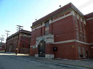
- Carnegie Library
- Homewood Cemetery
Further reading
- John Edgar Wideman talks about growing up in Homewood in his book Brothers and Keepers, in the section entitled "Our Time".
- Toker, Franklin (1994) [1986]. Pittsburgh: An Urban Portrait. Pittsburgh: University of Pittsburgh Press. ISBN 0-8229-5434-6.
- Kenneth Roland Williams Jr (K. Roland Williams) Urban Literature author and book publisher. Attended Westinghouse High School and graduated in 1986. Notable novels include: Cut Throat, Rekindled, Reigning Queen, and critically acclaimed Anthology: Romance For The Streets.
See also
References
- 1 2 3 4 5 6 "PGHSNAP 2010 Raw Census Data by Neighborhood". Pittsburgh Department of City Planning PGHSNAP Utility. 2012. Retrieved 24 June 2013. External link in
|publisher=(help) - ↑ "Pittsburgh Neighborhood Map". Retrieved 9 November 2012.
- 1 2 "Neighborhood Festivals - Dick's Sporting Goods Pittsburgh Marathon - UPMC Health Plan Pittsburgh Half Marathon - FedEx Ground Pittsburgh Marathon Relay". Retrieved 13 September 2013.
- 1 2 "Community_Profile" (October 2009). "Homewood: A Community Profile" (pdf). Retrieved 13 September 2013.
- ↑ "Pittsburgh City Planning". Retrieved 9 November 2012.
- ↑ "AreaVibes: Homewood". 2010. Retrieved 9 November 2012.
- ↑ "Community_Profile" (October 2009). "Homewood: A Community Profile" (pdf).
there are more employed women (approx. 15%) than there are men in the Homewood communities
External links
 Pittsburgh portal
 Media related to Homewood (Pittsburgh) at Wikimedia Commons
- Carnegie Library of Pittsburgh Homewood
- Interactive Pittsburgh Neighborhoods Map
- The Housing Authority of The City of Pittsburgh
- Pittsburgh Post-Gazette My Homewood Blog
- Homewood Nation, a community news website