Perry Park, Colorado
| Perry Park, Colorado | |
|---|---|
| Census-designated place | |
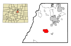 Location in Douglas County and the state of Colorado | |
| Coordinates: 39°15′0″N 104°59′10″W / 39.25000°N 104.98611°WCoordinates: 39°15′0″N 104°59′10″W / 39.25000°N 104.98611°W | |
| Country |
|
| State |
|
| County | Douglas[1] |
| Area | |
| • Total | 8.6 sq mi (22.2 km2) |
| • Land | 8.5 sq mi (22.1 km2) |
| • Water | 0.04 sq mi (0.1 km2) |
| Elevation[1] | 6,467 ft (1,971 m) |
| Population (2010) | |
| • Total | 1,646 |
| • Density | 192/sq mi (74.3/km2) |
| Time zone | Mountain (MST) (UTC-7) |
| • Summer (DST) | MDT (UTC-6) |
| ZIP code | 80118 |
| FIPS code | 08-58592 |
| GNIS feature ID | 1852847 |
Perry Park is a census-designated place (CDP) in Douglas County, Colorado, United States. The population was 1,646 as of the 2010 census,[2] up from 1,180 at the 2000 census.
Geography
Perry Park is located in south-central Douglas County at 39°15′0″N 104°59′10″W / 39.25000°N 104.98611°W (39.249906, -104.986020),[3] at the foot of the Rampart Range, the eastern edge of the Rocky Mountains in this area. It is 15 miles (24 km) southwest of Castle Rock, the Douglas County seat.
According to the United States Census Bureau, the CDP has a total area of 8.6 square miles (22.2 km2), of which 0.04 square miles (0.1 km2), or 0.41%, is water.[2] The community lies in the valleys of Bear Creek and Spring Creek, both tributaries of West Plum Creek and part of the South Platte River watershed.
Demographics
As of the census[4] of 2000, there were 1,180 people, 473 households, and 404 families residing in the CDP. The population density was 124.1 people per square mile (47.9/km²). There were 495 housing units at an average density of 52.1 per square mile (20.1/km²). The racial makeup of the CDP was 97.46% White, 0.25% Native American, 1.10% Asian, 0.08% Pacific Islander, 0.34% from other races, and 0.76% from two or more races. Hispanic or Latino of any race were 2.97% of the population.
There were 473 households out of which 28.3% had children under the age of 18 living with them, 82.7% were married couples living together, 2.5% had a female householder with no husband present, and 14.4% were non-families. 11.0% of all households were made up of individuals and 3.8% had someone living alone who was 65 years of age or older. The average household size was 2.49 and the average family size was 2.69.
In the CDP the population was spread out with 21.4% under the age of 18, 1.9% from 18 to 24, 21.3% from 25 to 44, 43.6% from 45 to 64, and 11.9% who were 65 years of age or older. The median age was 47 years. For every 100 females there were 101.7 males. For every 100 females age 18 and over, there were 97.4 males.
The median income for a household in the CDP was $88,408, and the median income for a family was $89,367. Males had a median income of $69,808 versus $51,477 for females. The per capita income for the CDP was $47,574. About 1.1% of families and 2.1% of the population were below the poverty line, including none of those under the age of eighteen or sixty-five or over.
See also
- Outline of Colorado
- State of Colorado
References
- 1 2 "US Board on Geographic Names". United States Geological Survey. 2007-10-25. Retrieved 2008-01-31.
- 1 2 "Geographic Identifiers: 2010 Demographic Profile Data (G001): Perry Park CDP, Colorado". U.S. Census Bureau, American Factfinder. Retrieved October 19, 2015.
- ↑ "US Gazetteer files: 2010, 2000, and 1990". United States Census Bureau. 2011-02-12. Retrieved 2011-04-23.
- ↑ "American FactFinder". United States Census Bureau. Retrieved 2008-01-31.
Municipalities and communities of Douglas County, Colorado, United States | ||
|---|---|---|
| Cities | 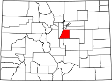 | |
| Towns | ||
| CDPs | ||
| Unincorporated communities | ||
| Footnotes | ‡This populated place also has portions in an adjacent county or counties | |