Pennsylvania Route 216
| ||||
|---|---|---|---|---|
 | ||||
| Route information | ||||
| Maintained by PennDOT | ||||
| Length: | 25.960 mi[1] (41.779 km) | |||
| Major junctions | ||||
| West end: |
| |||
|
| ||||
| East end: |
| |||
| Location | ||||
| Counties: | York | |||
| Highway system | ||||
| ||||

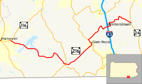
Pennsylvania Route 216 (PA 216) is a 26-mile-long (42 km) state highway located in York County, Pennsylvania. The western terminus is at PA 116 near Hanover. The eastern terminus is at PA 24 in Winterstown. PA 216 is a two-lane undivided road that passes through rural areas in southern York County, serving Sticks and Glen Rock. The route intersects PA 516 in Sticks, PA 616 in Glen Rock, and Interstate 83 (I-83) near Loganville.
PA 216 was designated in 1928 between PA 116 near Hanover and U.S. Route 30 (US 30) west of York, heading east to Glen Rock before it turned north and continued to US 30. In 1930, PA 216 was realigned to head east from Glen Rock to US 111 (Susquehanna Trail) south of Loganville, with PA 616 replacing the portion of the route between Glen Rock and US 30. The route was extended east to an interchange with I-83/US 111 in 1960 and to PA 24 in Winterstown in the 1960s.
Route description
PA 216 begins at an intersection with PA 116 in Penn Township, heading southeast on two-lane undivided Blooming Grove Road. The road passes residential subdivisions in the community of Blooming Grove, turning east into a mix of homes and woods. The route continues into forested areas of Codorus State Park and turns southeast to cross Lake Marburg into West Manheim Township before entering Manheim Township a short distance later. PA 216 curves east and crosses a couple arms of Lake Marburg before turning south through more forest. The route leaves the state park and passes through more hilly wooded areas with a few small farms and residences, making a sharp curve to the east. The road turns north and ascends a forested hill, making a bend to the southeast. PA 216 crosses the East Branch Codorus Creek into Codorus Township and passes through Brodbecks, where it crosses CSX's Hanover Subdivision railroad line. The road passes through more forests and runs a short distance to the east of the railroad tracks, reaching the residential community of Glenville. Here, the route heads southeast away from the railroad tracks and runs through woodland with some farms and homes. PA 216 curves east and intersects PA 516, becoming Sticks Road at this point. The road turns northeast into more hilly agricultural surroundings with a few areas of woods and residences, passing through Pierceville. The route passes through more areas of farms, woodland, and homes, crossing the Centerville Creek into Shrewsbury Township. Farther northeast, PA 216 heads into Glen Rock and becomes Manchester Street, entering residential areas. The road turns north and intersects PA 616.[2][3]
Here, PA 616 turns northwest to form a concurrency with PA 216 on Main Street, passing businesses in the center of town as it crosses the creek and the York County Heritage Rail Trail and the Steam into History tourist railroad. The road heads into more wooded areas again as it crosses back into Shrewsbury Township. PA 216 splits from PA 616 by heading northeast on Glen Rock Road into wooded areas of homes, crossing into Springfield Township. The road continues into a mix of farmland and woodland with a few homes, making a curve to the north. The route heads northeast again before it turns southeast onto Susquehanna Trail and passes through more agricultural areas. PA 216 turns northeast onto Seaks Run Road and heads through farmland with some businesses, reaching an interchange with I-83. After this, the road enters a mix of farm fields and woods, turning north before making a sharp turn to the east. The route winds northeast through forested areas with a few farms and homes. After crossing the East Branch Codorus Creek, PA 216 enters North Hopewell Township and turns southeast onto Swamp Road. The route heads through open farmland with a few scattered residences, crossing into Winterstown. Here, PA 216 reaches its eastern terminus at an intersection with PA 24.[2][3]
History
When Pennsylvania first legislated routes in 1911, what is now PA 216 was not given a number.[4] PA 216 was designated in 1928 to run from PA 116 east of Hanover east and north to US 30 west of York, following its current alignment east to Glen Rock before it turned north and ran through Seven Valleys before reaching US 30. At this time, the route was paved between PA 116 and west of Glenville, between east of Glenville and Glen Rock, and between Seven Valleys and US 30.[5] In 1930, PA 216 was realigned to head east from Glen Rock to US 111 (Susquehanna Trail) south of Loganville, with PA 616 designated onto the former alignment between Glen Rock and US 30. At this time, the entire length of PA 216 was paved.[6] By 1940, Seaks Run Road was an unpaved road while Swamp Road was a paved road.[7] Seaks Run Road was paved in the 1940s.[8] PA 216 was extended east to an interchange with I-83/US 111 in 1960.[9] The route was extended east from I-83 to PA 24 in Winterstown in the 1960s.[10]
Major intersections
The entire route is in York County.
| Location | mi[1] | km | Destinations | Notes | |
|---|---|---|---|---|---|
| Penn Township | 0.000 | 0.000 | |||
| Codorus Township | 10.412 | 16.756 | |||
| Glen Rock | 15.831 | 25.478 | South end of PA 616 concurrency | ||
| Shrewsbury Township | 16.539 | 26.617 | North end of PA 616 concurrency | ||
| Springfield Township | 20.693 | 33.302 | Exit 8 (I-83) | ||
| Winterstown | 25.960 | 41.779 | |||
1.000 mi = 1.609 km; 1.000 km = 0.621 mi
| |||||
See also
 U.S. Roads portal
 Pennsylvania portal
References
- 1 2 Bureau of Maintenance and Operations (January 2015). Roadway Management System Straight Line Diagrams (Report) (2015 ed.). Pennsylvania Department of Transportation. Retrieved June 30, 2015.
- York County (PDF)
- 1 2 Google (February 25, 2011). "overview of Pennsylvania Route 216" (Map). Google Maps. Google. Retrieved February 25, 2011.
- 1 2 York County, Pennsylvania Highway Map (PDF) (Map). PennDOT. 2011. Retrieved February 22, 2011.
- ↑ Map of Pennsylvania Showing State Highways (PDF) (Map). Pennsylvania Department of Highways. 1911. Retrieved January 1, 2014.
- ↑ Map of Pennsylvania (Map). Pennsylvania Department of Highways. 1928. Retrieved May 7, 2015.
- ↑ Tourist Map of Pennsylvania (PDF) (Map). Pennsylvania Department of Highways. 1930. Retrieved June 24, 2010.
- ↑ Official Road Map of Pennsylvania (PDF) (Map). Pennsylvania Department of Highways. 1940. Retrieved December 16, 2014.
- ↑ Official Road Map of Pennsylvania (PDF) (Map). Pennsylvania Department of Highways. 1950. Retrieved January 1, 2014.
- ↑ Official Map of Pennsylvania (PDF) (Map). Pennsylvania Department of Highways. 1960. Retrieved December 17, 2014.
- ↑ Official Map of Pennsylvania (PDF) (Map). Pennsylvania Department of Highways. 1970. Retrieved December 17, 2014.