Red Lion, York County, Pennsylvania
| Red Lion | ||
|---|---|---|
| Borough | ||
|
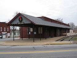
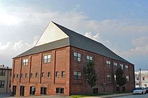
The former "Ma and Pa" railroad station in Red Lion | ||
| ||
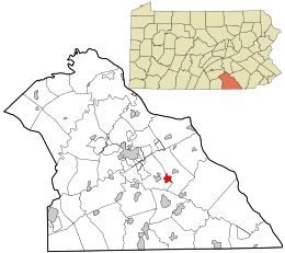 Location in York County and the state of Pennsylvania. | ||
| Coordinates: 39°53′56″N 76°36′23″W / 39.89889°N 76.60639°WCoordinates: 39°53′56″N 76°36′23″W / 39.89889°N 76.60639°W | ||
| Country | United States | |
| State | Pennsylvania | |
| County | York | |
| Settled | 1852 | |
| Incorporated | January 16, 1880 | |
| Named for | Red Lion Tavern | |
| Government | ||
| • Mayor | Steven Kopp | |
| • Council President | Kelly Henshaw | |
| Area | ||
| • Total | 1.28 sq mi (3.3 km2) | |
| • Land | 1.28 sq mi (3.3 km2) | |
| Elevation | 921 ft (281 m) | |
| Population (United States Census, 2010) | ||
| • Total | 6,373 | |
| • Density | 4,789.9/sq mi (1,849.4/km2) | |
| Time zone | EST (UTC-5) | |
| • Summer (DST) | EDT (UTC-4) | |
| ZIP code | 17356 | |
| Area code(s) | 717 | |
| Website | Official website | |

Red Lion is a borough in York County, Pennsylvania, settled in 1852 and incorporated on January 16, 1880. The population was 6,373 at the 2010 census.
History
Red Lion, settled in 1852, was named after one of the first pubs in town, the Red Lion Tavern.[1]
Red Lion was a main stop along the old Maryland and Pennsylvania Railroad, known locally as the "Ma & Pa" Railroad. That railroad ran from York County to Baltimore, Maryland.[2]
Red Lion was once famous for the many brands of cigars made in the town. The town produced millions of cigars per month, about 10% of the cigars made in the United States.[3] The town raises a cigar every New Year's Eve.[4]
Red Lion was also known nationwide for its furniture industry, with several large factories producing ornate, hand crafted furniture for over 100 years. The furniture industry has mostly shifted to kitchen cabinet production and retail store fixtures over the last 40 years.[5]
The Consumers Cigar Box Company and Red Lion Borough Historic District are listed on the National Register of Historic Places.[6]
Geography
Red Lion is located about 35 miles southeast of Harrisburg.[7]
According to the United States Census Bureau, the borough has a total area of 1.3 square miles (3.3 km²), all of it land.
Demographics
| Historical population | |||
|---|---|---|---|
| Census | Pop. | %± | |
| 1880 | 241 | — | |
| 1890 | 524 | 117.4% | |
| 1900 | 1,337 | 155.2% | |
| 1910 | 2,092 | 56.5% | |
| 1920 | 3,198 | 52.9% | |
| 1930 | 4,757 | 48.7% | |
| 1940 | 4,891 | 2.8% | |
| 1950 | 5,119 | 4.7% | |
| 1960 | 5,594 | 9.3% | |
| 1970 | 5,645 | 0.9% | |
| 1980 | 5,824 | 3.2% | |
| 1990 | 6,130 | 5.3% | |
| 2000 | 6,149 | 0.3% | |
| 2010 | 6,373 | 3.6% | |
| Est. 2015 | 6,321 | [8] | −0.8% |
| Sources:[9][10][11] | |||
As of the census[10] of 2000, there were 6,149 people, 2,575 households, and 1,645 families residing in the borough. The population density was 4,789.9 people per square mile (1,854.8/km²). There were 2,729 housing units at an average density of 2,125.8 per square mile (823.2/km²). The racial makeup of the borough was 97.12% White, 0.60% African American, 0.24% Native American, 0.41% Asian, 0.05% Pacific Islander, 0.33% from other races, and 1.25% from two or more races. Hispanic or Latino of any race were 0.91% of the population.
There were 2,575 households out of which 31.6% had children under the age of 18 living with them, 46.8% were married couples living together, 12.1% had a female householder with no husband present, and 36.1% were non-families. 29.6% of all households were made up of individuals and 11.0% had someone living alone who was 65 years of age or older. The average household size was 2.37 and the average family size was 2.92.
In the borough the population was spread out with 25.1% under the age of 18, 9.3% from 18 to 24, 32.2% from 25 to 44, 19.9% from 45 to 64, and 13.5% who were 65 years of age or older. The median age was 34 years. For every 100 females there were 92.9 males. For every 100 females age 18 and over, there were 86.8 males.
The median income for a household in the borough was $35,828, and the median income for a family was $41,850. Males had a median income of $31,595 versus $21,934 for females. The per capita income for the borough was $17,723. About 6.1% of families and 10.4% of the population were below the poverty line, including 17.4% of those under age 18 and 11.1% of those age 65 or over.
Schools
- Red Lion Area Senior High School
- Red Lion Area Junior High School
- Locust Grove Elementary School
- Windsor Manor Elementary School
- Larry J. Macaluso Elementary School
- Mazie Gable Elementary School
- Pleasant View Elementary School
- Clearview Elementary School
- North Hopewell-Winterstown Elementary School
On March 19, 2009 the Red Lion Area School Board voted 8-0 to close 2 elementary schools in the district. Chanceford and Edgar Moore elementary schools closed at the end of the 2009 school year. The students from the schools were placed in other schools throughout the district including a brand new elementary school. The new school, Larry J. Macaluso Elementary School, was completed in 2009 and is named after the Red Lion Area School District superintendent, who retired the same year.
School shooting
On April 24, 2003, at the Red Lion Junior High School in Red Lion, James Sheets killed the principal of the school, Eugene Segro, before killing himself.[7]
Local Venues
Red Lion is home to an extensive array of local underground bands and independent local artists, perhaps the most popular being Halestorm, who reached the top ten on the US Mainstream Rock charts and receives extensive local radio play.
Red Lion also had a fully functional opera house and a downtown movie theater until the mid-1960s. The opera house has since been converted to housing, and the movie theater was demolished and is now a parking lot.
Red Lion has many talented veteran and up and coming artists and musical talents of all genres (including funk, blues, jazz, bluegrass and country). The Guitar Spot USA and Tom's Music Trade are part of what's now known as a "Musician's Row" of sorts to local musicians and artists.
Red Lion Food
Red Lion supports 3 supermarkets, 32 restaurants including fast food, 3 beer stores and a state liquor store.
The Red Lion Mile
In 2007 construction began on a one mile long walking trail beginning at the Red Lion Historical Society Train Station and ending at Springwood Road. The Red Lion Mile runs along the old Maryland and Pennsylvania railway line and is 90% complete. The Red Lion Mile committee hopes to have it completed in the near future. Private and public donations keep the project going. In August 2009, a benefit music festival featuring local bands was held near the completed portion of the trail.
References
| Wikimedia Commons has media related to Red Lion, York County, Pennsylvania. |
- ↑ "History of Red Lion Borough". Red Lion, Pennsylvania. Retrieved 31 August 2015.
- ↑ "About the Maryland and Pennsylvania Railroad". THE MARYLAND AND PENNSYLVANIA RAILROAD HISTORICAL SOCIETY. Retrieved 31 August 2015.
- ↑ Kauffman, Christina (25 May 2011). "Last Red Lion cigar factory closes for good". York Dispatch. Retrieved 31 August 2015.
- ↑ Randall, Laura (2008). Eastern Pennsylvania: An Explorer's Guide. Woodstock, Vermont: The Countrymen Press. p. 201. ISBN 9780881507478.
- ↑ "National Historic Landmarks & National Register of Historic Places in Pennsylvania" (Searchable database). CRGIS: Cultural Resources Geographic Information System. Note: This includes Elizabeth L. Roman (February 2000). "National Register of Historic Places Inventory Nomination Form: Red Lion Borough Historic District" (PDF). Retrieved 2011-12-28.
- ↑ National Park Service (2010-07-09). "National Register Information System". National Register of Historic Places. National Park Service.
- 1 2 CNN: Red Lion Area Junior High School Shooting
- ↑ "Annual Estimates of the Resident Population for Incorporated Places: April 1, 2010 to July 1, 2015". Retrieved July 2, 2016.
- ↑ "Census of Population and Housing". U.S. Census Bureau. Retrieved 11 December 2013.
- 1 2 "American FactFinder". United States Census Bureau. Retrieved 2008-01-31.
- ↑ "Incorporated Places and Minor Civil Divisions Datasets: Subcounty Resident Population Estimates: April 1, 2010 to July 1, 2012". Population Estimates. U.S. Census Bureau. Retrieved 11 December 2013.