Pennsylvania Route 191
| |||||||
|---|---|---|---|---|---|---|---|
 | |||||||
| Route information | |||||||
| Maintained by PennDOT | |||||||
| Length: | 111.54 mi[1] (179.51 km) | ||||||
| Existed: | April 17, 1961[2] – present | ||||||
| Major junctions | |||||||
| South end: |
| ||||||
|
| |||||||
| North end: |
| ||||||
| Location | |||||||
| Counties: | Northampton, Monroe, Pike, Wayne | ||||||
| Highway system | |||||||
| |||||||

Pennsylvania Route 191 (PA 191) is a 111.54 mi (179.51 km)-long state highway in the U.S. state of Pennsylvania. The route, a major non-freeway corridor connecting the Lehigh Valley to The Poconos in eastern Pennsylvania, is designated from U.S. Route 22 in Brodhead to the New York state line over the Delaware River at Hancock, New York.
Commissioned on April 17, 1961, the route replaced the PA 12 and PA 90 numbers that were in place from the late 1920s to the 1960s. From 1961 to 1976, PA 191 was routed south of US 22 through Bethlehem and terminated at Pennsylvania Route 309 in Center Valley. Pennsylvania Route 378 replaced the designation from Center Valley to the Lehigh River crossing in Bethlehem.
Route description
Northampton County

PA 191 begins at an interchange with U.S. Route 22 in Bethlehem Township, as the Nazareth-Bethlehem Pike, a continuation of Linden Street from downtown Bethlehem. From there, PA 191 runs north-east past some rural and agricultural regions of Northampton County. Along the way, it intersects the eastern terminus of Pennsylvania Route 946 in Lower Nazareth Township.
PA 191 runs east of the former Nazareth Speedway, at the southern tip of Nazareth. The road enters the small borough from the south, while overlapping Pennsylvania Route 248 for two blocks. North of PA 248, PA 191 runs northward as Broad Street for five blocks past intersecting South, Evergreen, Park, Prospect, and Belvidere Streets and turns east onto Center Street for two blocks. The route then turns northward onto New Street in the northern sectors of Nazareth.
Outside of the borough, PA 191 is referenced as East Lawn Avenue, running eastward. East Lawn Avenue becomes Industrial Boulevard where PA 191 interchanges Pennsylvania Route 33. The route turns north onto Main Street, then northeast on Bangor Road in Stockertown. The route traverses several hills and more rural land in Washington Township. Between Stockertown and Bangor the road runs northeast. In Bangor, PA 191 becomes 1st Street, while intersecting Pennsylvania Route 512.
Outside of Bangor, PA 191 is known as Valley View Drive. The road traverses the Blue Mountain range at the Northampton-Monroe county line.[3]
Monroe and Pike counties

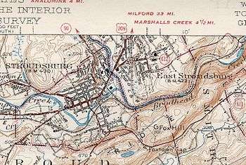
PA 191 enters the county at the summit of Blue Mountain as Godfrey Ridge Road. Upon entering Stroudsburg as Broad Street, the road intersects Pennsylvania Route 611. Traffic from PA 611 north has access only to I-80 east and US 209 northbound. Traffic from PA 191 north has access to I-80 west and US 209 southbound.
North of the I-80 overpass in downtown Stroudsburg, PA 191 intersects U.S. Route 209 Business, split into one-way couplets. PA 191 departs the downtown area as North 5th Street, running north and entering a more mountainous region of The Poconos. In the northern suburbs of the borough, the route briefly overlaps Pennsylvania Route 447 along the western banks of the Brodhead Creek. North of the 447 overlap, 191 intersects Pennsylvania Route 715, while the elevation along PA 191 rises northward. In Paradise Valley, the road turns northeast at the eastern terminus of Pennsylvania Route 940, soon curving northwest.
PA 191 then begins an overlap with Pennsylvania Route 390. The overlap ends in Mountainhome and PA 191 runs northwest along Chestnut Mountain. In Pike County, the route is known as La Anna Road for less than a mile.[3]
Wayne County
In the upper regions of The Poconos, PA 191 enters the final county of its course – Wayne. The route enters the county in South Sterling, where it intersects the northern terminus of Pennsylvania Route 423. PA 191 overlaps Pennsylvania Route 507 in the village of Newfoundland; Pennsylvania Route 447 terminates at the overlap. Away from the overlap with PA 507, PA 191 runs northwest. In the small village of Collapoose, PA 191 interchanges with Interstate 84, at exit 17.

Briefly north of I-84, PA 191 begins a concurrency with Pennsylvania Route 196. In Hamlin, the overlap intersects Pennsylvania Route 590. North of the village, PA 191 runs northeast from PA 196. In Lake Ariel, Pennsylvania Route 296 terminates at PA 191. Outside of the hamlet, PA 191 runs northeast as the Lake Ariel Highway.
In Honesdale, PA 191 enters the borough as Erie Street. Main Street, the main arterial of Honesdale, serves as the overlap for U.S. Route 6 and PA 191, for two blocks. North of the overlap, PA 191 intersects the southern end of Pennsylvania Route 670. Outside of Honesdale, PA 191 runs northeast, traversing mostly mountainous and rural land. In Rileyville, PA 191 becomes the Hancock Highway and intersects Pennsylvania Route 371. The Hancock Highway continues northward and begins to parallel the Delaware River.
Pennsylvania Route 370, is the final junction of the route in Pennsylvania, approximately two to four miles (6 km) southeast of Hancock, New York. The Hancock Highway becomes Pennsylvania Avenue, as PA 191 crosses the Delaware River and enters New York. In Hancock, the short Pennsylvania Avenue intersects New York State Route 97, less than a mile from exit 87 of New York State Route 17.[3]
History
| |
|---|---|
| Location: | Center Valley–Bartonsville |
| Existed: | 1930s–1961 |
| |
|---|---|
| Location: | Easton–Hancock, New York |
| Existed: | 1928–1961 |
In the 1920s and 1930s, the first 191 number was designated from the Baltimore Pike in Clifton Heights to Penrose Avenue in southwest Philadelphia.[4] The first state highway numbers to be assigned on the modern PA 191 were Pennsylvania Route 12 and Pennsylvania Route 90. PA 90 was designated from Stroudsburg to the New York-Pennsylvania border. The section from Center Valley to Stockertown was designated as part of PA 12 (which then went north to Wind Gap and Saylorsburg). From the 1920s to the 1940s, the designation between Stockertown and Stroudsburg had no signed traffic route.[5][6] When both routes were commissioned, several spurs were as well. For Route 90, the following spurs were assigned in The Poconos region: Pennsylvania Routes 190, 290, 390, 490, 590, and 690. For Route 12, the following spurs were assigned in The Poconos and Lehigh Valley regions: Pennsylvania Routes 212, 312, 412, 512, 612, and 712.[7]
In April 1935, PA 12 was extended north to US 611 in Bartonsville, filling a gap between Snydersville and Bartonsville.[8][9] By 1950, PA 90 was extended south to Easton, including the highway between Stroudsburg and Stockertown.[10] On April 17, 1961, PA 191 was commissioned from the New York state line to U.S. Route 309 in Center Valley. The route replaced PA 12 south of Stockertown (the rest would be superseded by the Route 33 freeway) and PA 90 north of Stockertown (the rest remained part of Route 115 until 1972). In Bethlehem, PA 191 was designated onto Wyandotte Street, crossed the Lehigh River, went onto Main Street, turned onto Elizabeth Avenue, and turned onto Linden Street or Nazareth-Bethlehem Pike north of the city. PA 191 was designated to replace PA 12 and PA 90 in order to provide a continuous route between Center Valley and the New York border as well as to reduce confusion with I-90 in the northwest part of the state.[2][11]
By 1970, when Pennsylvania Route 378 was commissioned, PA 191 moved designations slightly in Bethlehem. Southbound 191 came from Nazareth, as Linden Street, and in Bethlehem, it turned west onto Union Boulevard. After it passed underneath I-378, the route turned south onto 3rd Street then onto the I-378 freeway. I-378 terminated at the bridge that crosses the Lehigh River and it continued as PA 191 (Wyandotte Street). By 1976, PA 191 was truncated to end at its current location and Pennsylvania Route 378 (formerly I-378) replaced its former routing from the Lehigh River bridge to Pennsylvania Route 309 in Center Valley.[12][13]
Major intersections
| County | Location | mi[1] | km | Destinations | Notes | |||
|---|---|---|---|---|---|---|---|---|
| Northampton | Bethlehem Township | 0.00 | 0.00 | Interchange. Continues south of Route 22 as Linden Street into Bethlehem. | ||||
| Lower Nazareth Township | 1.98 | 3.19 | Eastern terminus of PA 946. | |||||
| Nazareth | 4.27 | 6.87 | Southern terminus of concurrency. | |||||
| 4.48 | 7.21 | Northern terminus of concurrency. | ||||||
| Stockertown | 7.50 | 12.07 | Interchange. | |||||
| Bangor | 16.93 | 27.25 | ||||||
| Monroe | Stroudsburg | 26.03 | 41.89 | |||||
| 26.46 | 42.58 | Exit 307 (I-80/US 209). | ||||||
| 26.52 | 42.68 | Southern terminus of concurrency with US 209 Bus. southbound. | ||||||
| 26.63 | 42.86 | Northern terminus of concurrency with US 209 Bus. southbound. | ||||||
| Stroud Township | 30.55 | 49.17 | Southern terminus of concurrency. | |||||
| 33.05 | 53.19 | Northern terminus of concurrency. | ||||||
| Paradise Township | 35.41 | 56.99 | Northern terminus of PA 715. | |||||
| 38.37 | 61.75 | Eastern terminus of PA 940. | ||||||
| 39.91 | 64.23 | Southern terminus of concurrency. | ||||||
| Barrett Township | 41.97 | 67.54 | Northern terminus of concurrency. | |||||
| Pike |
No major junctions | |||||||
| Wayne | Dreher Township | 50.52 | 81.30 | Northern terminus of PA 423. | ||||
| 53.42 | 85.97 | Southern terminus of concurrency. | ||||||
| 54.79 | 88.18 | Northern terminus of PA 447. | ||||||
| 55.22 | 88.87 | Northern terminus of concurrency. | ||||||
| Sterling Township | 59.42 | 95.63 | Exit 17 (I-84). | |||||
| 60.33 | 97.09 | Southern terminus of concurrency. | ||||||
| Salem Township | 63.24 | 101.77 | ||||||
| 64.38 | 103.61 | Northern terminus of concurrency. | ||||||
| Lake Township | 66.90 | 107.67 | Southern terminus of PA 296. | |||||
| Honesdale | 78.42 | 126.20 | Southern terminus of concurrency. | |||||
| 79.04 | 127.20 | Northern terminus of concurrency. | ||||||
| 79.65 | 128.18 | Southern terminus of PA 670. | ||||||
| Lebanon Township | 89.56 | 144.13 | ||||||
| Buckingham Township | 110.46 | 177.77 | Northern terminus of PA 370. | |||||
| Delaware River | 111.54 | 179.51 | Hancock Bridge | |||||
| Delaware | Village of Hancock | 111.54 | 179.51 | New York state line | ||||
| 1.000 mi = 1.609 km; 1.000 km = 0.621 mi | ||||||||
PA 191 Truck
| |
|---|---|
| Location: | Northampton County |
| Existed: | May 2014–March 2016 |
Pennsylvania Route 191 Truck was a route that followed PA 248, PA 33, and the exit slip-ramps at the PA 33-PA 191 interchange. It was signed in 2014. Signs were removed and PA 191 Truck was decommissioned in 2016.
See also
 U.S. Roads portal
 Pennsylvania portal
References
- 1 2 DeLorme Street Atlas USA 2007 software
- 1 2 "Routes 12-90 Renumbered '191' by State Highways". The Daily Record. April 15, 1961. Retrieved August 5, 2015 – via Newspapers.com.

- 1 2 3 Google (2007-10-13). "overview map of Route 191" (Map). Google Maps. Google. Retrieved 2007-10-13.
- ↑ Statewide Map (back) (PDF) (Map). Pennsylvania Department of Highways. 1930. Retrieved 2007-10-14.
- ↑ Eastern Half of map (Map). Pennsylvania Department of Highways. 1929. Retrieved 2007-10-14.
- ↑ Tourist Map of Pennsylvania, Showing the State Highway System and Main Connecting Roads (PDF) (Map). Pennsylvania Department of Highways. 1930. Retrieved 2013-08-29.
- ↑ Statewide Map (PDF) (Map). Pennsylvania Department of Highways. 1940. Retrieved 2007-10-14.
- ↑ "State to Change Route Numbers". The Plain Speaker. Hazleton, Pennsylvania. April 18, 1935. p. 12. Retrieved January 13, 2016 – via Newspapers.com.
- ↑ Official Road Map of Pennsylvania (PDF) (Map). Pennsylvania Department of Highways. 1940. Retrieved December 16, 2014.
- ↑ Statewide Map (PDF) (Map). Pennsylvania Department of Highways. 1950. Retrieved 2007-10-14.
- ↑ Northampton County Map (PDF) (Map). Pennsylvania Department of Highways. 1961. Retrieved 2007-10-14.
- ↑ Statewide Map (back) (PDF) (Map). Pennsylvania Department of Highways. 1970. Retrieved 2007-10-14.
- ↑ Northampton County Map (PDF) (Map). PennDOT. 1976. Retrieved 2007-10-14.
External links
| Wikimedia Commons has media related to Pennsylvania Route 191. |
- Pennsylvania Highways: PA 151 - 200
- PA State Route 191 Ends
- PA Routes 191-200 - Central PA/MD Routes