Palo Alto, Mississippi
|
Town of Palo Alto | |
  | |
| Location | Clay County, Mississippi northwest of West Point |
|---|---|
| Coordinates | 33°40′50″N 88°48′0″W / 33.68056°N 88.80000°WCoordinates: 33°40′50″N 88°48′0″W / 33.68056°N 88.80000°W |
| Area | 196.4 acres (79.5 ha) |
| Built | 1846 |
| NRHP Reference # | 87000473[1] |
| Added to NRHP | August 20, 1987 |
Palo Alto (also Savannah) is a ghost town in Clay County, Mississippi.[2] Established c. 1846,[1] it is located at 33°40′50″N 88°48′0″W / 33.68056°N 88.80000°W (33.6806738, -88.8000525) at an elevation of 279 feet (85 m).[2]
In 1987, the townsite was listed on the National Register of Historic Places under the name of "Town of Palo Alto." Nearly 200 acres (81 ha) were listed on the Register as part of the community.[1]
References
- 1 2 3 National Park Service (2009-03-13). "National Register Information System". National Register of Historic Places. National Park Service.
- 1 2 U.S. Geological Survey Geographic Names Information System: Palo Alto, Mississippi
| Topics | |
|---|---|
| Lists by states |
|
| Lists by insular areas | |
| Lists by associated states | |
| Other areas | |
| |
Municipalities and communities of Clay County, Mississippi, United States | ||
|---|---|---|
| City | 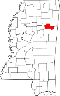 | |
| Unincorporated communities | ||
| Ghost town | ||
This article is issued from Wikipedia - version of the 11/28/2016. The text is available under the Creative Commons Attribution/Share Alike but additional terms may apply for the media files.