Palmyra, Virginia
| Palmyra, Virginia | |
|---|---|
| Census-designated place | |
|
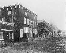
Fluvanna County administrative and legal buildings in Palmyra | |
 Palmyra Location within Fluvanna county | |
| Coordinates: 37°51′40″N 78°15′48″W / 37.86111°N 78.26333°WCoordinates: 37°51′40″N 78°15′48″W / 37.86111°N 78.26333°W | |
| Country | United States |
| State | Virginia |
| County | Fluvanna |
| Area | |
| • Total | 1.42 sq mi (3.69 km2) |
| • Land | 1.42 sq mi (3.67 km2) |
| • Water | 0.01 sq mi (0.03 km2) |
| Elevation | 305 ft (93 m) |
| Population (2010) | |
| • Total | 104 |
| • Density | 74/sq mi (28.4/km2) |
| Time zone | Eastern (EST) (UTC-5) |
| • Summer (DST) | EDT (UTC-4) |
| ZIP code | 22963 |
| FIPS code | 51-60392 |
| GNIS feature ID | 1498526 |

Palmyra is a census-designated place (CDP) in and the county seat of Fluvanna County, Virginia, United States.[1] The population as of the 2010 census was 104.[2] Palmyra lies on the eastern bank of the Rivanna River along U.S. Route 15. The ZIP code for Palmyra and surrounding rural land is 22963.
The Fluvanna County Courthouse Historic District, Glen Burnie, Pleasant Grove, and Seay's Chapel Methodist Church are listed on the National Register of Historic Places.[3]
History
Before being named "Palmyra", the area was owned by the Timberlake family, and Reverend Walter Timberlake started a business there in 1814 called "Palmyra Mills".[4]
The village of Palmyra was founded and became the county seat of Fluvanna County in 1828, and its historic courthouse was built in 1830-1831.[5] By 1835, there were fourteen homes, a church, three factories, and various other businesses, though only two families owned all the land other than the public buildings.[4] In the mid-19th century, it was a stop along the stagecoach route between Richmond and Staunton.[6] The Virginia Air Line Railway, which operated from 1908 to 1975, ran through Palmyra. The train traveled from Strathmore on the James River, to Cohasset, to Carysbrook, to Palmyra, to Troy, and on to Gordonsville or Charlottesville.
A fire in 1930 destroyed many of the buildings on Main Street. As a result of the Great Depression, a smaller version of Palmyra was rebuilt after the fire.[4]
Geography
Palmyra is in central Fluvanna County, on a hillside rising to the northeast above the Rivanna River. U.S. Route 15 passes through the community, crossing the Rivanna at the south end of town. US 15 leads north 20 miles (32 km) to Gordonsville and south 51 miles (82 km) to Farmville. Virginia State Route 53 intersects US 15 just south of the Rivanna River and leads northwest 20 miles (32 km) to Charlottesville.
According to the U.S. Census Bureau, the Palmyra CDP has a total area of 1.4 square miles (3.7 km2), of which 0.01 square miles (0.03 km2), or 0.70%, is water.[7]
Climate
Palmyra's climate is characterized by relatively high temperatures and evenly distributed precipitation throughout the year. The Köppen Climate Classification subtype for this climate is "Cfa"(Humid Subtropical Climate).[8]
| Climate data for Palmyra, Virginia | |||||||||||||
|---|---|---|---|---|---|---|---|---|---|---|---|---|---|
| Month | Jan | Feb | Mar | Apr | May | Jun | Jul | Aug | Sep | Oct | Nov | Dec | Year |
| Average high °C (°F) | 8 (47) |
9 (49) |
14 (58) |
21 (69) |
24 (75) |
28 (83) |
30 (86) |
30 (86) |
26 (79) |
21 (69) |
15 (59) |
9 (49) |
19 (67) |
| Average low °C (°F) | −4 (25) |
−3 (26) |
0 (32) |
5 (41) |
10 (50) |
16 (60) |
18 (64) |
17 (63) |
13 (56) |
6 (43) |
1 (34) |
−3 (27) |
6 (43) |
| Average precipitation mm (inches) | 74 (2.9) |
71 (2.8) |
91 (3.6) |
74 (2.9) |
94 (3.7) |
89 (3.5) |
104 (4.1) |
100 (4) |
86 (3.4) |
94 (3.7) |
79 (3.1) |
80 (3) |
1,034 (40.7) |
| Source: Weatherbase [9] | |||||||||||||
Notable residents
- Chris Adler, from the band Lamb of God
- Willie Adler, from the band Lamb of God
- Chris Daughtry, musician (American Idol, Daughtry), graduated from Fluvanna County High School in 1998. His parents still live in the area.
- Texas Jack Omohundro (1846-1880), frontier scout, actor, and cowboy born on the Pleasure Hill farm in Palmyra[10]
References
- ↑ "Find a County". National Association of Counties. Retrieved 2011-06-07.
- ↑ Virginia Trend Report 2: State and Complete Places (Sub-state 2010 Census Data). Missouri Census Data Center. Accessed 2011-06-08.
- ↑ National Park Service (2010-07-09). "National Register Information System". National Register of Historic Places. National Park Service.
- 1 2 3 "Historic Palmyra Virginia" (PDF). Fluvanna County Historical Society. Retrieved 4 March 2014.
- ↑ "Fluvanna County History". County of Fluvanna, Virginia. Retrieved 4 March 2014.
- ↑ Smith, John Calvin (1847). The Illustrated Hand-book, a New Guide for travelers through the United States of America. New York City: Sherman & Smith. p. 132.
- ↑ "Geographic Identifiers: 2010 Demographic Profile Data (G001): Palmyra CDP, Virginia". U.S. Census Bureau, American Factfinder. Retrieved October 19, 2016.
- ↑ Climate Summary for Palmyra, Virginia
- ↑ "Weatherbase.com". Weatherbase. 2013. Retrieved on August 20, 2013.
- ↑ http://www.hmdb.org/marker.asp?marker=11676
Municipalities and communities of Fluvanna County, Virginia, United States | ||
|---|---|---|
| Towns | 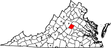 | |
| CDPs | ||
| Unincorporated communities |
| |
| Footnotes | ‡This populated place also has portions in an adjacent county or counties | |