Palaui Island
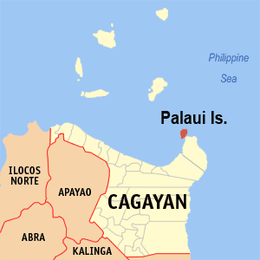 Location within Cagayan province | |
.svg.png) Palaui Island Location within the Philippines | |
| Geography | |
|---|---|
| Location | Babuyan Channel |
| Coordinates | 18°32′46″N 122°8′11″E / 18.54611°N 122.13639°ECoordinates: 18°32′46″N 122°8′11″E / 18.54611°N 122.13639°E |
| Length | 10 km (6 mi) |
| Width | 5 km (3.1 mi) |
| Administration | |
| Region | Cagayan Valley |
| Province | Cagayan |
| Municipality | Santa Ana |
| Barangay | San Vicente |
Palaui Island is one of the islands in the Philippines, located off the northeastern extremity of Luzon Island, the largest island in the country.
Geography
Palaui Island lies off the northwestern part of a large promontory in San Vicente, in the municipality of Santa Ana, Cagayan province. It is 10 kilometres (6.2 mi) at its longest and about 5 kilometres (3.1 mi) at its widest and moderately high. The western shore of the island appears bold, but on the eastern side, a reef projects from its side for 2.4 kilometres (1.5 mi), the edge of it being 0.8 kilometres (0.50 mi) from and extending around the small islet of Escucha, east of Palaui. The Dos Hermanos rocky islets lie off Cape Engaño, in the northern point of Palaui, and there are some rocks off the northeast point of the island, about 1.6 kilometres (0.99 mi) eastward of the cape. Gran Laja island, a low rock islet surrounded by breakers, is one of the rocks located northeast off Palaui.[1][2]
At the southwest end of Palaui Island is Puerto Point, a high, wooded bluff. East of the point and south of Palaui is Rona Island, a low, wooded island with a white base of sand and rocks. Escucha Island is a high and wooded islet east of Palaui, and beyond Rona Island when seen from southwestward through the channel between Palaui Island and the mainland, where a few more islets are located.[1]
Flora and Fauna
Palaui Island was declared as a National Marine Reserve in August 28, 1994 encompassing an area of 7,145 hectares (17,660 acres).[3] The waters around the island boast of 21 commercial species of fishes with about 50 hectares (120 acres) of undisturbed corals.
Because of its remoteness, Palaui Island is home to 105 species of rattan and similar commercially valuable timber producing wood species plus 25 imported shrubs and is the sanctuary for 90 migratory birds.[4]
Places to go
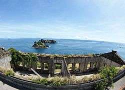
The northern point of the island is called Cape Engaño where on the summit of the hill lie the ruins of Cape Engaño Lighthouse. Engaño Cove[5] is a small cove southwest of the lighthouse where supplies for the station were previously landed. Today, small vessels can find good anchorage in this protected cove, except by northwesterly and westerly winds. A trail and a 229-step concrete stairway from the cove leads the travelers to the lighthouse.[6]
The Port of San Vicente in Santa Ana, Cagayan, situated between Palaui Island and the coast of Luzon, is the jump-off point for crossing the channel to Punta Verde (Point Verde) on Palaui Island, or heading to Engaño Cove, a little further to the north. The hike from Punta Verde, the southeast tip of Palaui, to Cape Engaño takes about 3.5 to 4 hours of hike through beautiful verdant scenery. Primitive camping is allowed at the lighthouse vicinity.[7]
History
In 2013, it was used as the filming location for Survivor: Blood vs. Water and Survivor: Cagayan. On May 2013, Palaui Island earned the 10th spot in the CNN's World's 100 Best Beaches list, with CNN praising its "raw beauty."[8]
See also
References
- 1 2 U.S. Coast and Geodetic Survey. "United States Coast Pilot, Part 1", pp. 44-45. Washington Government Printing Office, 1919.
- ↑ Peters, Jens. "Philippines Travel Guide, 2nd edition", p.368. Jens Peters Publications, 2005. ISBN 3-923821-32-8.
- ↑ "Protected Areas in Region 2". Protected Areas and Wildlife Bureau of the Philippines. Retrieved on 2011-04-12.
- ↑ Lactaoen, Vic Albornoz (2009-12-17). "Palaui Island's Cape Engaño Lighthouse". Travels with Vic. Retrieved on 2011-04-12.
- ↑ "Cagayan: On rough seas to Palaui Island and Cape Engaño Lighthouse". En Route - Ironwulf.net. Retrieved on 2011-03-12.
- ↑ Samson, RJ (2010-09-27). "Cape Engaño Lighthouse, Palaui Island Cagayan North Series". The Island Explorer. Retrieved on 2011-03-12.
- ↑ Moymoy (2007). "Cape Engaño Lighthouse". Waypointsdotph. Retrieved on 2011-04-10.
- ↑ http://edition.cnn.com/2013/05/28/travel/100-best-beaches/index.html