Otterbein, Ohio
| Otterbein, Ohio | |
|---|---|
| Unincorporated community | |
 Location of Otterbein, Ohio | |
| Coordinates: 39°56′45″N 84°40′18″W / 39.94583°N 84.67167°WCoordinates: 39°56′45″N 84°40′18″W / 39.94583°N 84.67167°W | |
| Country | United States |
| State | Ohio |
| County | Darke |
| Township | Butler |
| Elevation | 1,109 ft (338 m) |
| Time zone | Eastern (EST) (UTC-5) |
| • Summer (DST) | EDT (UTC-4) |
| GNIS feature ID | 1062926[1] |
Otterbein (also Otterbine) is an unincorporated community in southwestern Butler Township, Darke County, Ohio, United States. It lies at the intersection of Otterbin Ithaca and Preble County Butler Township Roads southwest of the city of Greenville, the county seat.[2] Its elevation is 1,109 feet (338 m). Because the community has borne multiple names, the Board on Geographic Names officially designated it "Otterbein" in 1963.[1]
References
- 1 2 "Otterbein, Ohio". Geographic Names Information System. United States Geological Survey. Retrieved 2008-03-18.
- ↑ DeLorme. Ohio Atlas & Gazetteer. 7th ed. Yarmouth, 2004, p. 64.
Municipalities and communities of Darke County, Ohio, United States | ||
|---|---|---|
| City | 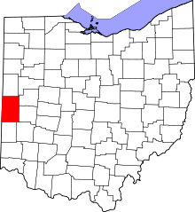 | |
| Villages | ||
| Townships | ||
| Unincorporated communities | ||
| Footnotes | ‡This populated place also has portions in an adjacent county or counties | |
This article is issued from Wikipedia - version of the 9/4/2016. The text is available under the Creative Commons Attribution/Share Alike but additional terms may apply for the media files.