Otsego, West Virginia
| Otsego | |
|---|---|
| Unincorporated community | |
 Otsego  Otsego Location within the state of West Virginia | |
| Coordinates: 37°36′37″N 81°22′35″W / 37.61028°N 81.37639°WCoordinates: 37°36′37″N 81°22′35″W / 37.61028°N 81.37639°W | |
| Country | United States |
| State | West Virginia |
| County | Wyoming |
| Time zone | Eastern (EST) (UTC-5) |
| • Summer (DST) | EDT (UTC-4) |
Otsego is an unincorporated community in Wyoming County, West Virginia, United States, along the Slab Fork and West Virginia Route 54.[1] It was also known as Caloric.
Otsego is a name derived from a Native American language.[2]
References
- ↑ West Virginia Atlas & Gazetteer. Yarmouth, Me.: DeLorme. 1997. p. 58. ISBN 0-89933-246-3.
- ↑ Kenny, Hamill (1945). West Virginia Place Names: Their Origin and Meaning, Including the Nomenclature of the Streams and Mountains. Piedmont, WV: The Place Name Press. p. 464.
Municipalities and communities of Wyoming County, West Virginia, United States | ||
|---|---|---|
| City | 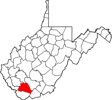 | |
| Towns | ||
| CDPs | ||
| Unincorporated communities |
| |
| Footnotes | ‡This populated place also has portions in an adjacent county or counties | |
This article is issued from Wikipedia - version of the 7/28/2016. The text is available under the Creative Commons Attribution/Share Alike but additional terms may apply for the media files.