Orin, Wyoming
| Orin, Wyoming | |
|---|---|
| CDP | |
 Orin, Wyoming | |
| Coordinates: 42°39′12″N 105°11′33″W / 42.65333°N 105.19250°WCoordinates: 42°39′12″N 105°11′33″W / 42.65333°N 105.19250°W | |
| Country | United States |
| State | Wyoming |
| County | Converse |
| Area | |
| • Total | 1.1 sq mi (2.9 km2) |
| • Land | 1.0 sq mi (2.6 km2) |
| • Water | 0.1 sq mi (.3 km2) |
| Elevation | 4,705 ft (1,434 m) |
| Population (2010)[1] | |
| • Total | 46 |
| • Density | 41/sq mi (16/km2) |
| Time zone | Mountain (MST) (UTC-7) |
| • Summer (DST) | MDT (UTC-6) |
| Area code(s) | 307 |
| FIPS code | 56-58100[2] |
| GNIS feature ID | 1592478[3] |
Orin is a census-designated place (CDP) in Converse County, Wyoming, United States. The population was 46 at the 2010 census.
History
A post office called Orin Junction was established in 1891, the name was changed to Orin in 1895, and the post office closed in about 1962.[4] The community was named for Orin Hughitt, the uncle of a railroad official.[5]
Geography
The community is located at the intersection of Interstate 25/U.S. Route 26/U.S. Route 87 and U.S. Route 18/U.S. Route 20. Orin is about 10 miles (16 km) southeast of Douglas. A BNSF Railway line runs through the community.
According to the United States Census Bureau, the CDP has a total area of 1.1 square miles (2.9 km²), 1.0 square miles (2.6 km²) of it land and 0.1 square miles (0.26 km²) (9.1%) of it water.[6]
References
- ↑ "2010 City Population and Housing Occupancy Status". U.S. Census Bureau. Archived from the original on July 21, 2011. Retrieved July 13, 2012.
- ↑ "American FactFinder". United States Census Bureau. Retrieved 2008-01-31.
- ↑ "US Board on Geographic Names". United States Geological Survey. 2007-10-25. Retrieved 2008-01-31.
- ↑ "Converse County". Jim Forte Postal History. Retrieved 1 March 2015.
- ↑ Chicago and North Western Railway Company (1908). A History of the Origin of the Place Names Connected with the Chicago & North Western and Chicago, St. Paul, Minneapolis & Omaha Railways. p. 111.
- ↑ "2010 Wyoming Place Names". U.S. Census Bureau. Retrieved July 13, 2012.
Municipalities and communities of Converse County, Wyoming, United States | ||
|---|---|---|
| City | 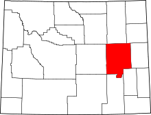 | |
| Towns | ||
| CDPs | ||
| Unincorporated communities | ||